| TRAIL NAME |
NATIONAL FOREST NAME/DISTRICT |
PHONE NUMBER |
STATUS |
DATE UPD. |
Alta Lakes Road
FR623 |
Uncompahgre/Ouray |
970-240-5300 |
|
|
COMMENTS:
|
| |
| Animas Forks |
Uncompahgre/Ouray |
970-240-5300 |
Open |
6/27/17 |
COMMENTS:
|
6/27/17 - 6/27/17 - Travelled Corkscrew Gulch to Hurricane Pass to California Pass on to Animas Forks. All open. Trails are mostly in good shape. Some rutting due to snow melt.
4/15/17 - Open all the way, though we turned around at the Picayune Gulch turn off.
Still some recent wind-blown snow on the road, but passable. Nice, heavy snow banks the plows cut through lined the road. Photos of the approach
here and here.
|
Argentine Pass/Waldorf Mine
FR248 |
White River/Dillon |
970-468-5400 |
Open |
9/21/17 |
COMMENTS:
|
9/21/17 - Forest Service on-site with tracked vehicle, doing some scraping. Reasonable conditions for my Rubicon with some more amusing spots. Went up to Argentine Pass and saw 3 mountain sheep. Santiago Mine now blocked off a few hundred feet from the mine, not even any foot traffic allowed. (lead and arsenic in the soil, supposedly). Take 248.1 to the Waldorf site, where a hair-turn north is not obvious and is the easy way further up. Another road is directly uphill from the upper flat area at the Waldorf site, and is more interesting.
7/19/17 - Open to the pass.
7/14/17 - One sizable snowfield still blocking the trail to the pass, a mile or so on from Waldorf, easily visible from below. Also some snow left on upper Mt McClellan. Afternoons can be overcast/wet like today... maybe another two weeks? Good conditions otherwise.
6/17/17 - The lower roa/d is open all the way to intersection with main trail again. Creek crossings are 2 feet or more. Upper road, is clear to waldorf site.
The Argentine pass road is blocked by alot of snow as far as you can see. Santiago mine is accessible, but not beyond. Santiago mine is also now roofless and damaged due to poor construction on the remodel.
|
| Alpine Tunnel |
San Isabel/Salida |
719-539-3591 |
Partially Open |
6/21/17 |
COMMENTS:
|
| 6/21/17 - Closed at junction with Hancock Pass - there is severe road damage.
About a mile above the closure- at the Palisade Wall - the road has been taken out. Looks like the result of boulders and erosion. You can hike the three miles to the tunnel though.
|
| Aspen Ridge (CR 175)/Bassam Park (CR 187) |
San Isabel |
719-486-0749 |
Mostly Open |
|
COMMENTS:
|
| 3/25/17 - Mostly open all year. |
| Bald Mountain Trail |
White River/Dillon |
970-468-5400 |
Open |
9/7/17 |
COMMENTS:
|
| 9/7/17 - Located just outside Breckenridge (not the Mt Baldy trail near CS).
Spectacular near 360-degree views from summit, mountain ranges and Breckenridge Ski Hill to be seen. Relatively easy trail for 4x4, some moderately amusing spots. Continue on Baldy Rd from downtown Breck, zig-zag up mountain passing several mines. Clear and dry. Side path FS 5281 B dead-ends in about a mile.
|
Ballard Road
FR129 |
Fort Collins Region |
|
|
|
COMMENTS:
|
| |
| Bangs Canyon |
BLM |
Grand Junction |
Open |
4/30/17 |
COMMENTS:
|
4/30/17 - The Tabeguache Trail is open and brush has been trimmed by the Grand Mesa Jeep Club.
The Windmill Loop is also open. The Tabeguache Trail is getting quite rough again. Many protruding rocks from the surface.
The top of the Windmill Loop near the intersection with the Tabeguache is also showing signs of erosion and is difficult.
ATVs have been braiding (widening) the trail avoiding rocks in the trail. Please stay on the trail or stay home.
|
| Barbour Forks |
White River/Dillon
Pike/South Platte |
970-468-5400
303-275-5610 |
Partially Open |
6/10/17 |
COMMENTS:
|
| 6/10/17 - The seasonal gate is still closed. I couldn't see any snow from the entry. |
| Billings Canyon |
BLM |
Grand Junction |
Open |
3/26/17 |
COMMENTS:
|
| 3/26/17 - Billings Canyon is open all the way. Billings canyon is an extreme Jeep trail. 37" tire minimum with 2 locking differentials and a winch minimum. Please stay on the trail at ALL times.
Expect body damage and/or breakage. Rollovers are highly possible.
|
Billings Lake
CR240 |
Chaffee County |
719-539-6961 |
|
|
COMMENTS:
|
| 3/25/17 - In 2016, the Forest Service repaired ruts on the North Fork Reservoir Road access to this trail. |
Bill Moore Lake
FR183.1 |
Clear Creek |
303-567-3000 |
Open |
7/2/17 |
COMMENTS:
|
7/2/17 - Open to the lake all the way. Downed tree at the bottom of the final decent to lake on the edge of the trail. narrow in this spot but passable.
6/24/17 - Not open all the way. About 1/2 from the lake there are some large snow drifts. We managed to get by the first couple but at the bottom of the final hill there was a good 30' of road blocked by 2-3 foot drift.
6/3/17 - Not totally open. Managed to get 75% of the way. Winched through a few drifts, but could not get past 39.792004, -105.689944. Pretty good apart from that.
4/13/17 - Trail is blocked by snow at fork in road where forest service sign indicates left to Bill Moore Lake and right to Miller Lake.
We made it through the chutes area but one large snowdrift at the start required winching through it.
|
| Birdseye Gulch |
Pike/South Park
Leadville County |
719-836-2031 |
Open |
9/14/17 |
COMMENTS:
|
9/14/17 - A good alternative to the long boring entry from Leadville to Mosquito Pass. Start at MM 5.3 on US 91, going uphill most of the time. Cross the Leadville RR track. Reported severe mud bogs have disappeared, with some water, steep, tight spaces and moderate rocks remaining. In the trees until near Mosquito Pass roads. After RR track, left fork dead-ends at creek. About 5 miles.
6/28/17 - Open all the way no snow. |
Black Bear Pass
FR648 |
Uncompahgre/Ouray |
970-327-4835 |
Closed |
10/17/17 |
COMMENTS:
|
10/17/17 - Closed due to multiple snowfields above treeline on both sides. Made it to the top from the 550 side and down to the bench above the shaded "Black Face" on the Telluride side. Had to chain up & shovel to get back up to the top from the Telluride side.
7/15/17 - BBP is clear all the way to the bottom.
7/13/17 - San Miguel County website says the pass is open as of 7/13.
7/1/17 - Open to the pass. No activity on San Miguel County side. Lots of snow over road.
6/27/17 - They say in Ouray closed. We went from Telluride up to Bridal Veil Falls which is spectacular with the large amount of water and spray creating rainbows. Columbines and even the red shooting star columbines. The waterfall at the mine where the boarding house once stood is also spectacular with large amounts of runoff and spray, but from afar.
4/14/17 - Closed by San Miguel County. |
| Blacktail Creek |
Routt |
|
|
|
COMMENTS:
|
| |
| Blowout Pass |
Rio Grande/Divide |
|
|
|
COMMENTS:
|
| |
Bolam Pass
FR578 |
Uncompahgre/Ouray |
970-240-5300 |
Closed |
4/14/17 |
COMMENTS:
|
| 4/14/17 - Closed. |
Boreas Pass
CR 10/CR 3 |
White River/Dillon |
970-468-5400 |
Open |
6/10/17 |
COMMENTS:
|
| 6/10/17 - Open all the way. Road is in good condition. |
Breakneck and Browns Passes
FR175/176) |
Pike/Fairplay |
719-836-2031 |
Open |
8/28/17 |
COMMENTS:
|
| 8/28/17 - Open and clear. Many mud bogs mostly dry. Drove from 5 to Breakneck, back via Browns. Took a rarely traveled south path (before 426), unmarked on map and Google, wound around and ended up back on 5 (Great views at top of mountain meadow). |
Bull Park
FR376 |
Pike |
719-836-2031 |
Partially Open |
4/22/17 |
COMMENTS:
|
| 4/22/17 - Open for the first 4.8 miles. |
Bunce School Trail System
FR115 |
Boulder |
303�541-2500 |
Open |
7/13/17 |
COMMENTS:
|
|
7/13/17 - The trail is open all the way to Camp Dick. T-33 is open to the plane crash site.
|
| Calamity Mesa |
BLM Grand Junction |
303-239-3600 |
Open |
5/20/17 |
COMMENTS:
|
| 5/20/17 - The trail is open. We did some erosion control and repair in some places.
This is a difficult trail (6 or 6+) - (8 and dangerous when wet). There are 11-named obstacles on this trail... just to give you an idea of the difficulty level. NO FULL-SIZE vehicles!!! There are two places you will not make it.
|
| California Gulch |
Uncompahgre/Ouray |
970-240-5300 |
|
|
COMMENTS:
|
| |
| California Pass |
Uncompahgre/Ouray |
970-240-5300 |
Open |
6/27/17 |
COMMENTS:
|
6/27/17 6/27/17 - Travelled Corkscrew Gulch to Hurricane Pass to California Pass on to Animas Forks. All open. Trails are mostly in good shape. Some rutting due to snow melt.
4/14/17 - Closed by San Juan County. |
Caribou Creek
FR505.1 |
Boulder |
303-541-2500 |
Open |
8/11==6/17 |
COMMENTS:
|
8/6/17 - Nissan Off Road Association of Colorado opened Caribou Creek today from Eldora to Rainbow Lakes. Large rock that was keeping the trail closed was removed by the Forest Service.
Trail is very rough because of spring runoff erosion. Switchbacks on the Eldora side feel very narrow.
7/11/17 - The trail is closed both on the north side and the south side indefinitely per the US Forest Service because a 4'X 4'x 4' boulder landed on the Eldora switchbacks blocking the road. the US forest service says the road won't open till the boulder is removed. There is no time frame established for the removal of the boulder.
6/11/17 - Entrance still closed off CR116. |
Carnage Canyon
(Buena Vista) |
San Isabel/Salida |
719-539-3591 |
|
|
COMMENTS:
|
| |
| Cascade Creek |
Clear Creek |
303-567-3000 |
Open |
6/17/17 |
COMMENTS:
|
|
6/17/17 - The trail is open all the way.
|
| Cement Creek Road |
Gunnison/Gunnison |
970-641-0471 |
|
|
COMMENTS:
|
| |
| Chalk Mountain |
White River/Holy Cross |
970-827-5715 |
|
|
COMMENTS:
|
| |
Chihuahua Gulch
FR263 |
White River/Dillon |
970-468-5400 |
Open |
9/16/17 |
COMMENTS:
|
9/16/17 - Definitely rougher than the last time we ran it, which was 2015. The initial uphill section seemed more rocky, the flat, muddy section more rutted (though it is nearly completely dry by this time of year), and the corduroy road section seems a little rougher, too. Highly recommend the hike that starts at the end of the road, which goes up to Chihuahua lake, beautiful. Herd of goats greeted us at the lake.
8/23/17 - Open all the way, and fairly dry in normally muddy sections. Seems to be more difficult than in 2016, on upper part.
7/1/17 - The trail is open all the way. Quite a bit of water from run off. |
Chinaman Gulch
BLM 6044 |
San Isabel/Salida |
719-539-3591 |
Open |
4/14/17 |
COMMENTS:
|
| 4/16/17 - Trail fully open. No downed trees or other obstructions.
|
China Wall
FR204,212 |
Pike/Fairplay |
719-836-2031 |
Open |
6/15/17 |
COMMENTS:
|
6/15/17 - Trail is open and dry all the way. Moderate traffic the day we were there. There are few fun
obstacles and the scenery is great.
5/10/17 - China Wall is closed until 15 June. This trail is no longer open all year. |
Chinns Lake
FR174.1D |
Clear Creek |
303-567-3000 |
Open |
11/6/17 |
COMMENTS:
|
11/6/17 - The trail is open all the way to Upper Chinns Reservoir.
The trail has around an inch of snow, however, due to vehicle traffic most of the trail has turned into a sheet of ice. The ice makes the trail difficult without an experienced driver.
7/15/17 - Trail open all the way and clear.
6/16/17 - Snowfield on shelf road 1.5 ft deep a few hundred yards from the lake, lifted 4x4 or winch needed to cross. Should melt off in the next week.
|
Cinnamon Gulch
FR262 |
White River/Dillon |
970-468-5400 |
Partly open |
8/3/17 |
COMMENTS:
|
8/3/17 - The trail is intentionally blocked by large boulders a short distance above the Pennsylvania mine. There is a sign stating closed for revegatation. I suspect the reclamation work mentioned previously about this trail occurred in the upper basin and they are now hoping plants will regrow.
Access to the mine and mill is still available.
2017 - Colorado Mining and Safety is cleaning up the Pennsylvania Mine during 2017. This trail is likely closed at this time. |
| Cinammon Pass |
Uncompahgre/Ouray
BLM/Gunnison |
970-240-5300
970-641-0471 |
Open |
5/24/17 |
COMMENTS:
|
5/24/17 - Open all the way to Silverton.
4/14/17 - Closed by San Juan County. |
| Clear Lake |
Uncompahgre/Ouray |
970-240-5300 |
Open |
7/5/17 |
COMMENTS:
|
7/5/17 - Trail is open all the way to Clear Lake. One snow patch near the lake. Road is in good condition.
6/22/17 - trail stops at waterfall. SNOW! |
Coney Flats
FR507.1 |
Boulder |
303-541-2500 |
Open |
6/25/17 |
COMMENTS:
|
6/25/17 - Opened today thanks to the hard work of the Tralridge Runners off road club. I understand about 30 trees were cleared. And a lot of other maintainence at the upper water crossing.
6/25/17 - The Coney Flats 4WD road is open all the way from Beaver Reservoir to the Wilderness trail head and on down the cut off to the Middle St. Vrain 4WD road.
The mud holes and water crossings are full with our late May snow. The main Coney Creek Crossing at the top is high with the heavy run off.
|
| Coon Hollow |
BLM Grand Junction |
303-239-3600 |
Open |
4/23/17 |
COMMENTS:
|
| 4/23/17 - The Grand Mesa Jeep Club reopened Coon Hollow. Miles of brush cutting were required to make your trip enjoyable
and a downed tree was removed from the road. The views are still fantastic and the trail has some "Jeepy" places that will
garner your complete attention. |
| Corkscrew Gulch |
Uncompahgre/Ouray
BLM/Gunnison |
970-240-5300
970-641-0471 |
Open |
6/27/17 |
COMMENTS:
|
6/27/17 - Travelled Corkscrew Gulch to Hurricane Pass to California Pass on to Animas Forks. All open. Trails are mostly in good shape. Some rutting due to snow melt.
5/25/17 - According to the Ouray County Road and Bridge Facebook page, Corkscrew is open to the 2nd water crossing-still in progress.
4/14/17 - Closed by San Juan County. |
Cottonwood Pass
FR209/FR306 |
San Isabel/Salida |
719-539-3591
|
Closed |
7/16/17 |
COMMENTS:
|
7/16/17 - The pass is closed on the west side (paving to Taylor Res). Open on the east side to the summit,for 2017.
3/25/17 -Cottonwood Pass will be closed this summer so that they can pave the Gunnison side. |
Crooked Creek
FR194,669 |
Pike/South Park |
719-836-2031 |
|
|
COMMENTS:
|
| |
Cumberland Gulch
FR271.1D |
Clear Creek |
303-567-3000 |
|
|
COMMENTS:
|
| |
| Cumberland Pass |
Gunnison NF/Gunnison District |
970-641-0471
|
Open |
7/25/17 |
COMMENTS:
|
| 7/25/17 - Beautiful and smooth sailing. We traveled in a stock 2010 Ford Explorer and never needed 4x4. The road was surprising smooth, but was a little rougher on the Taylor Park side. Not even a single blemish. |
| Cunningham Gulch |
Uncompahgre/Ouray |
970-240-5300 |
Partially Open |
4/17/17 |
COMMENTS:
|
| 4/17/17 - Open to the snow. |
Dakan Road
CR44 |
Pike/Fairplay |
719-836-2031 |
Open |
5/11/17 |
COMMENTS:
|
| 5/11/17 - All gates are open. Trail fully open.
No apparent damage to trail from recent heavy rains and spring run-off.
|
| Deer Creek |
White River/Dillon |
970-468-5400 |
Open |
7/1/17 |
COMMENTS:
|
| 7/1/17 - Yes, it's open all the way and I good shape. We went up St. John's that had only on patch of snow on a switchback but was passable and then came down Deer Creek back to Montezuma. |
| Democrat Mountain |
Arapaho/Clear Creek |
303-567-3000 |
|
|
COMMENTS:
|
| |
| Devil's Canyon |
White River/Dillon
Pike/South Platte |
970-468-5400
303-275-5610 |
|
|
COMMENTS:
|
| |
| Dolores Point |
BLM |
Grand Junction |
Open |
5/19/17 |
COMMENTS:
|
5/19/17 - The Delores Overlook is open all the way.
The Delores Overlook trail is an easy trail for any high clearance vehicle. The overlook is of the Delores River Valley as it round
Steamboat Mesa and the Cottonwood Canyon which is home to Rose Garden Hill of Moab fame. The views of other surrounding trails
and mesas are well worth the trip.
4/8/17 - Delores Point is open. The Grand Mesa Jeep Club did the necessary work to reopen the trail to the end.
3/22/17 - Delores Point is open all the way to the end. The road along the mesa rim overlooking the Delores Valley and Gateway, CO, is heavily overgrown. The Grand Mesa Jeep will be trimming the trees necessary for easy access sometime in the next month. The views from the rim road and at the end of the roads past the airstrip are fantastic. The main road out to the point is in very good condition.
Please allow time for the deer to slowly move away. Most are still pregnant and do not need any unnecessary stress.
Bring a good camera and a spotting scope. Other trails (areas) visible from Delores Point include The Palisade WSA, Sheep Creek, Steamboat Mesa, Delores Overlook, Sevenmile Mesa, Top of the World, Cottonwood Canyon (Rose Garden Hill), Polar Mesa, North and South Beaver Mesas, and Tenderfoot Mesa.
|
| Eagle Rock |
Teller County |
Near Colorado Springs |
Open |
6/3/17 |
COMMENTS:
|
| 6/3/17 - Trail is open all the way. Easier than most years as the run off has filled in a lot of the ruts. |
| Eldorado Mountain |
Boulder |
303�541-2500 |
|
|
COMMENTS:
|
| |
| Elwood Pass |
Rio Grande/Conejos
San Juan/Pagosa |
719-274-8971
970-264-2268 |
Open |
7/27/17 |
COMMENTS:
|
|
7/27/17 - Trail is open all the way. Trail is the worst it has been in years. Elwood creek is now running down a section of the trail. It has increased the degree of difficulty but is passable but may require at least rear lockers. Some ATV riders were tentative to use the trail at the washout area.
|
| Engineer Pass |
Uncompahgre/Ouray
BLM/Gunnison |
970-240-5300
970-641-0471 |
Partially Open |
10/6/17 |
COMMENTS:
|
10/6/17 - Closed at the summit due to snow.
7/9/17 - Open All the Way Including Lower Engineers for loop planning purposes. Forest Service Website still shows Lower Engineers closed by Rock Slide, however it is not! Lower Engineers is getting rougher requiring a rear traction aid in places, but whatever rock slide has been cleared. I did see some construction signs laid down so maybe it was cleared recently.
6/9/17 - According to the Lake City Facebook page: "Sorry for the confusion folks - We got some signals crossed earlier - Engineer Pass is OPEN! It is the Ouray side of Engineer, Mineral Creek Road, that is closed due to a rock slide. You can ride the whole loop as of June 6th, but it is in very rough shape so proceed with extreme caution!"
6/7/17 - According to Ouray County Road and Bride, "HIGH COUNTRY ROAD UPDATE: Due to a rock slide on County Road 18 (ENGINEER PASS) the road will remain closed in both directions until further notice."
6/6/17 - Open from Animas Forks to Lake City per forest service.
5/24/17 - Will not be open for Memorial Day weekend. It may be open in another week.
4/14/17 - Closed by San Juan County. |
| Fourmile Travel Area |
San Isabel/Salida |
719-486-0749
719-539-3591 |
Open |
3/25/17 |
COMMENTS:
|
| 3/25/17 - Some sections open all year. Gates will open for the seasonal sections on 4/15/17.
|
| Garibaldi Gulch |
White River/Dillon |
970-468-5400 |
|
|
COMMENTS:
|
| |
| Geneva Creek |
White River/Dillon
Pike/South Platte |
970-468-5400
303-275-5610 |
Open |
7/17/17 |
COMMENTS:
|
7/17/17 - Geneva Creek in now open and dry all the way from Duck Creek Picnic area to Sill Mine about seven miles. Nice wildflowers above timberline. The roses are starting to bloom. There has been a lot of moisture so mushrooming should be good in August.
7/8/17 - Trail is open up to the small lake at the top. All routes above the lake were still blocked by snow before reaching mine sites.
Trail is rather dry already. The creek crossings were low, and the water holes were no more than 2' deep.
6/3/17 - Blocked by snow just beyond the lower Iron Fens gate. Hiked to mining district, lots of snow up high. Maybe 2 - 3 weeks before it's passable.
5/7/17 - Open until snow drifts at N39° 33.341' W105° 45.404' 10,005ft. |
| Georgia Pass |
White River/Dillon |
970-468-5400 |
Open |
6/24/17 |
COMMENTS:
|
6/24/17 - The trail is open from Jefferson down into Breckenridge. MHJC did a lot of trail maintenance on Saturday including tree removal, shoveling snow drifts, and closing illegally created bypasses. Very little snow remains, but there is one section of about 50 yards that is an ice sheet about 2 feet thick in the shade on the Breck side. It is slick but manageable. Not sure how long that will stick around.
6/23/17 - At least partially open. Not sure how far trails are open; Mile High Jeep Club was in the area trying to clear
trails this weekend. All gates are now open and most trails in the area should be open.
6/6/17 - Snowed in 3 blocks from the top on the Jefferson side. Thick heavy wet snow. It needs some tree triming.
5/11/17 - This is an update to the previous post about a tree blocking the road. That tree has been removed By the Sasquatch Jeepers from Mile-Hi Jeep Club. The road is open another half mile beyond that before it's completely snow-covered. It's about 1 foot deep and it's that loose granular sugar snow that gives you no traction. A group of well-equipped vehicles could make it a bit further.
5/6/17 - Partially open. Went up from the Jefferson side. At about 4 miles from the 870/54 intersection the trail is blocked by a large tree.
Dry at the start with some avoidable snowdrifts a couple miles in. Changes to all snow as you approach the downed tree at 39.4382094, -105.9149148. Had to turn back here and had some fun getting out of the snow.
|
| Gold Hill/Switzerland Trail |
Boulder |
303-541-2500 |
Open |
4/2/17 |
COMMENTS:
|
4/2/17 - Open all the way. Traveled the entire trail North to South.
Light snow in shaded areas. Wet but not very muddy.
4/1/17 - Trail is open. Did not drive it north of Gold Hill road but the rest of the trail is clear
A few puddle from the recent rain and snow, but no worse dor wear than a few years ago.
|
Goose Creek Road
CR44 |
Pike/Fairplay |
719-836-2031 |
|
|
COMMENTS:
|
| |
| Gordon Gulch |
Roosevelt National Forest |
970-498-1100 |
|
|
COMMENTS:
|
| |
| Governor Basin |
Uncompahgre/Ouray |
970-240-5300
970 |
Open |
7/29/17; |
COMMENTS:
|
7/29/17 - It is open. There is a snow drift about half a mile from the top. However, a samaritan has built up a rock tire support on the downhill side of the drift over which we made it in a rental jeep. It was harrowing, but we made it. Above the top mine, there is an off camber spot, and the work around trail is blocked by snow. Other than that, simply breathtaking.
7/27/17 - Trail open to approx 1/3 of a mile past the turn off to Sydney Basin where it is still blocked by snow. We were traveling alone so did not attempt to press further. Beyond were more drifts so continuing would have been pointless anyway. In a JKUR we were able to get turned around in small widening of road prior to drifts.
One watershed crossing that requires higher clearance and/or careful tire placement due to erosion on the far side of the crossing.
|
| Granite Creek Canyon |
BLM |
|
Open |
5/14/17 |
COMMENTS:
|
| 5/14/17 - Granite Creek is open. Granite Creek is open and the brushy trailsides have been trimmed back by the Grand Mesa Jeep Club. The shelf road has been cleared of all the rockfall obstacles, so is not as technical.
|
| Green Ridge Road |
Roosevelt National Forest |
970-498-1100 |
|
|
COMMENTS:
|
| |
| Greer Road |
Roosevelt National Forest |
970-498-1100 |
|
|
COMMENTS:
|
| |
| Grizzly Lake |
San Isabel/Salida |
719-539-3591
|
Closed |
8/22/17 |
COMMENTS:
|
8/22/17 - Probably a temporary closure. There is a closed sign on saw-horses and a "Blasting area" sign also.
6/24/17 - We cleared the Grizzly trail of all the trees and debris on June 24th. Trail is open and clear all the way. Photohere.
6/20/17 - Trail is open until about 200 yards short of the lake. 3 or 4 full grown trees have fallen across the trail.
No snow in the way. Must have been some avalanches during the winter as there are numerous downed trees up higher some partially blocking the trail.
6/13/17 - Trail was open until about tree line where avalanche debris was blocking the trail. If trees are removed I believe the lake can be reached.
5/29/17 - Not open all the day, open/dry through gatekeeper and up scree slope. Ran into first snow at the second creek crossing about half way.
Unpassable for my 35's shortly into snow, guy on 37's made it another mile. Avalanches from winter 1 mile from lake are ~10ft deep over trail. May not be dry until near July. Lake itself has spots of open water but largely still iced over.
|
Guanella Pass
CR62 |
White River/Dillon
Pike/South Platte |
970-468-5400
303-275-5610 |
Open |
7/13/17 |
COMMENTS:
|
| 7/13/17 - Open, blacktopped and dry from Georgetown to Grant. We went over from Grant to Georgetown today and also the weekend before the 4th of July. Today was clear sailing, but the holiday weekend was crazy. Cars parked on the blacktop both direction so only one car could pass. The weekends have so many hikers parking every where at the top of the pass to hike Bierstadt Mt. Clear Creek County is going to have to look at what to do about the hazards both to the road way and the mountain. |
| Gunsight Pass |
White River/Sopris District |
970-963-2266 |
|
|
COMMENTS:
|
| |
Hackett Gulch
FR220 |
Pike National Forest |
Near Colorado Springs |
4/17/17 |
Open |
COMMENTS:
|
| 4/17/17 - Camped and ran the whole loop. Trails are clear both ways. Normal trail hazards exist. |
Hagerman Pass
FR105
|
San Isabel/Leadville
White River/Sopris |
719-486-0749
970-963-2266 |
Open |
6/25/17 |
COMMENTS:
|
6/25/17 - I was able to get to the summit of Hagerman Pass from the Basalt side. Gate was open and snow field on Leadville side of summit was plowed.
The pass was mostly dry, with patchy wet areas near summit. here and here.
6/22/17 - Traveled from Basalt/Ruedi side. Gate closed at intersection with Road 527 (Ivanhoe Lakes Road). Clear
and dry and in good shape below this. |
Halfmoon Creek
FR110 |
San Isabel/Leadville |
719-486-0749 |
Partially Open |
9/5/17 |
COMMENTS:
|
9/5/17 - Open and mostly dry all the way to Champion Mine, with gate open at cabin. Mine looking a bit more sagging. Water crossing on 110 fairly shallow, but rocky. Water at 110J to Iron Mike also fairly shallow (take left exit from creek). Overall relatively easy for a 4x4. Hardest part was the boring long entrance road that was quite washboarded and bumpy.
7/23/17 - Trail to Champion Mine is closed at snowdrift across trail at 12,300 above the Champion Mill. Appears to be a boulder after the snowdrift that would also be a very tight squeeze. Trail to Iron Mike Mine open all the way.
Both Champion Mine Trail and Iron Mike Trail in good shape. Fun day on trail. Creek crossings were 2 feet.
7/3/17 - This is still closed for the section below.
6/11/17 - Half Moon is passable all the way to the Champion Mill gate. Please be aware that there is a very small forestry
sign on the right hand side of the road just before you get to the gate that says NO VEHICLES BEYOND THIS POINT. I was told while I was up there
that the fine is $1,000 per tire for driving beyond that point plus a trespassing citation. Seems pretty crazy to me since the sign is so hard to see.
Just trying to give you a heads up and hopefully save you some money.
There were a few snow areas towards the top. Most capable rigs will be fine traveling in the tracks that are there. Please Stay The Trail. River was pretty high yesterday at the crossings. I was driving a JKU Rubicon on 37's and a 3.5" lift and the river came up over the hood briefly when crossing.
|
Hancock Pass
FR295,299 |
San Isabel/Salida |
719-539-3591 |
Open |
9/13/17 |
COMMENTS:
|
9/13/17 - : St. Elmo is one of the few remaining ghost towns, preserved as it was c.1900, with buildings in various stages of disrepair. Any car can get to St. Elmo via 277 from the east. Bring food for the chipmunks, across from the open general store in St. Elmo. Buy something, they need the money. Pass to Tincup ok, with one obvious area just west of the pass needing careful spotting. Some rough areas, and high-clearance desirable (easy enough in my Rubicon, no skid plates required). Drove south on 765 (very easy), and east to Hancock Pass to make a loop. Hancock was very rough, with some steep areas, again high-clearance and occasional spotting needed (only scraped bottom once). About 45 miles in 6+ hours, back to St. Elmo.
7/13/17 - Hancock Pass is open all the way from by St. Elmo to Pitkin and dry. When you leave the railroad grade and continue two miles to the top of the pass and down the other side there are abundant, beautiful wild flowers and LOTS of mosquitoes....!!
7/7/17 - Trail from Pitkin side is blocked by snow 500 yards below the pass. Unfortunately, numerous riders have created a new trail through the tundra in order to get to the top. STAY THE TRAIL,the pass has been damaged by this unethical riding. Why, if other side is blocked??
6/24/17 - From St Elmo, trail is passable to the treeline. Snow drifts 2-3 feet deep once past the trees into the tundra. Expect trail will not be passable for another few weeks.
5/25/17 - Trail is clear up to the entrance of Mary Murphy Mine trail, approximately 3 miles in. From there the trail is littered with snow drifts only passable by a high clearance rig.
5/13/17 - Partially Open. Trail is wet with a little snow until 1.8 miles from Chalk Creek Dr. It is then solid snow 2'-3' deep. |
Hayden Pass
FR970 |
Rio Grande/Saguache
San Isabel/Salida |
719-655-2547
719-539-3591 |
Open |
6/10/17 |
COMMENTS:
|
|
6/10/17 - Open all the way through. I traveled from west to east.
There is one tricky spot where a snowdrift still blocks about half of the road for about 20 feet on the east side about a half mile from the top.
The donhill side is a bit soft from the snowmelt. I was able to put 2 tires on the drift and 2 on the dirt and was fine. It should open up a bit better in a week or 2, but it's passable now.
|
| Heart Lake |
Rio Grande
Divide |
719-655-2547 |
|
|
COMMENTS:
|
| |
| Hermit Pass |
Rio Grande/Saguache
San Isabel/San Carlos |
719-655-2547
719-269-8500 |
Open |
8/4/17 |
COMMENTS:
|
| 8/4/17 - Open to the top with a snowdrift near the top switch-back, that has plenty of room to pass. The road is in generally good condition for a 4x4 vehicle.
|
| Hidden Valley Trail |
Pike/South Platte |
303-275-5610 |
|
|
COMMENTS:
|
| |
| Holy Cross City |
San Isabel/Holy Cross |
970-827-5715 |
|
|
COMMENTS:
|
| |
| Hurricane Pass |
Uncompahgre/Ouray |
970-240-5300 |
Open |
6/27/17 |
COMMENTS:
|
6/27/17 - Travelled Corkscrew Gulch to Hurricane Pass to California Pass on to Animas Forks. All open. Trails are mostly in good shape. Some rutting due to snow melt.
4/14/17 - Closed by San Juan County. |
Imogene Pass
FR869 |
Uncompahgre/Ouray |
970-327-4835 |
Open |
7/4/17 |
COMMENTS:
|
7/4/17 - Imogene is OPEN. The trail is in good condition considering it's been under snow for months. Tall, narrow one-lane/ one-way routes through some of the longer drifts. Be prepared to back up to a wide place. Visibility is not far in some of those places, so you can't anticipate meeting someone.
7/3/17 - San Miguel County website reports it as open.
4/14/17 - Closed by San Miguel County. |
Independence Pass
CO82 |
Lake/Pitkin Counties |
|
Open |
5/25/17 |
COMMENTS:
|
5/24/17 - Opens 12:00 pm 5/25/2017.
5/19/17 - Open for the season. |
| Independence Trail |
Canyon City |
|
|
|
COMMENTS:
|
| |
| Iron Chest |
San Isabel/Salida |
719-539-3591
|
Open |
7/1/17 |
COMMENTS:
|
7/1/17 - The Iron Chest mine road just opened and is clear all the way to the mine.
Photos here, here and here.
5/13/17 - Nothing but snow a few hundred yards into the trail.
|
| Italian Creek Road/Upper Reno Divide |
Gunnison/Gunnison |
970-641-0471 |
Open |
9/7/17 |
COMMENTS:
|
9/7/17 - Coming from Cement Creek, about two miles or so from the fence and turn to Reno, the corner that is traditionally washed out is the worst I've seen
in 10 years. No workaround available, and unless you have a really long winch cable, nothing to hook onto if you're alone.
Stock vehicles used to be able to traverse this trail. I wouldn't recommend this trail for the remainder of the season if your rig isn't modified or
you aren't travelling in a group. Just my $.02.
8/23/17 - I'd never traveled this trail, so maybe it's a known "no-travel" route on Italian Creek, but I was using Chuck's 2005 Colorado Backroads book that listed the "upper" as a difficult option, just ledgy. There appears to have been a rock-slide since that book went to print as there are VW-sized rocks at about 38.921932, -106.740149. After coming to those coordinates and having to dangerously back down the ledge road, I would highly advise against attempting this trail unless you know what you're looking for. I am a fully locked wrangler on 35's and feel like I know what I'm doing. There was what looked to be a Nissan truck about 100 feet below - crushed and upside-down. I would highly recommend walking this route from the first ledge road, just past the creek you cross heading south before venturing out on to the ledge road as there is absolutely no place to Austin Powers a 180. Just be careful. I ran in to a Flight for Life guy up there, not sure what he was doing bu t he said he was keeping an eye on us before heading down via the lower route as he thought we might release another slide. Highly not recommended.
Taylor Pass, Italian Creek, and the Lower Reno Divide are all great.
8/6/17 - Italian Creek is open all the way. Did not do Reno Divide. |
| Jenny Creek Trail |
Clear Creek |
303-567-3000 |
Open |
7/3/17 |
COMMENTS:
|
| 7/3/17 - Trail is completely open. The final snow drift does still partially exist though passable. |
| Jones Pass |
Clear Creek |
303-567-3000 |
Open |
8/26/17 |
COMMENTS:
|
8/26/17 - Open all the way. A little bit of snow to cross at the top.
7/6/17 - No. Clear until switchback/hard-left at lower end of upper shelf section; about 12,120' elevation.
Snow blocking above mentioned turn. 99+% dry surface before that - minor water flowing across road surface and a few water filled 'pot-holes'.
|
Kebler Pass
CR12 |
Paonia; |
970-527-4131 |
Open |
5/25/17 |
COMMENTS:
|
| 5/25/17 - Scheduled to open 5:00 pm 5/25/2017. |
| Kelly Flats |
Canyon Lakes |
970-295-6700 |
Open |
6/6/17 |
COMMENTS:
|
6/3/17 - Did not travel it. Forest service road status page lists it as open as of 6/3.
5/27/17 - Closed at Gate. Fallen trees and snow
|
| Kendall Peak and Kendall Mountain |
Uncompahgre/Ouray |
970-240-5300 |
Mostly Open |
7/8/17 |
COMMENTS:
|
| 7/8/17 - You can go almost to the top of Kendall Mountain.
The trail to Kendall Gulch is open all the way to the end and it's in great shape. Take the fork toward the top of Kendall Mountain and we were stopped
just before the end by a snow field. If you are familiar with this trail, on the way to the top there is a notch that you can park in and view toward
the northeast. The top of Kendall Mt is in the upper right. The notch is just right of the jeep in my picture.
This is the farthest you can go. The snowfield is not far and the notch is a drop-off making it impossible to continue to the right.
|
| Kennebec Pass |
San Juan Public Lands |
970-247-4874 |
Closed |
4/14/17 |
COMMENTS:
|
| 4/14/17 - Closed. |
Kingston Peak
FR353 |
Clear Creek |
303-567-3000 |
Closed |
10/17/17 |
COMMENTS:
|
10/17/17 - The Clear Creek Ranger District has closed Kingston Peak for the season on October 16, 2017.
Due to snow, several vehicles got stuck the second week of October, requiring rescue and bringing attention to safety conditions on the road.
The emergency closure went into effect Monday, Oct. 16, 2017, restricting all motorized vehicle access on portions of Kingston Peak Road (NSFR 353.1)
between the gate located approximately one and one-half miles north of the town site of Alice/ St. Mary's Glacier, and the gate near the intersection
of 772.1, a couple miles before the James Peak Lake Trailhead.
7/25/17 - Yes, ran north to south, both gates open. Trail is in good condition.
7/16/17 - No.Gate Closed at Sheridan Hill & Kingston Peak for possible rocks or whatever.
7/9/17 - No, north gate still closed.
6/14/17 - Gate closed from Apex. Hiked the peak from the gate. Saw snow covering sections of north trail.
6/1/17 - Large snow drifts still block the trail south from Rollinsville just past the fork to Mammoth Gulch.
The road up to the fork was completely clear, but wet.
|
| Lamartine/Saxon Mountain |
Clear Creek |
303-567-3000 |
Open |
9/18/17 |
COMMENTS:
|
9/18/17 - Rock slide might have been removed, but there are still several 2'-3' tall boulders in the middle of Saxon Mtn trail, with rocks stacked so you go over the boulders (no going around). Very tight quarters for my Rubicon, and the first time I needed rock-rails. Wider/longer vehicles may not make it. Shear dropoffs and narrow trails make meeting another 4x4 tough. Went from Georgetown to Lamartine to Cascade Creek (some rough areas).
6/17/17 - The trail is open all the way. The rock slide has been removed. The trail is in great shape. |
LaSalle Pass
CR44 |
Pike/Fairplay |
719-836-2031 |
|
|
COMMENTS:
|
| |
Last Dollar Road
FR638 |
Uncompahgre/Ouray |
970-327-4835 |
Open |
6/27/17 |
COMMENTS:
|
6/27/17 - Dry and dusty all the way, but good wildflowers.
5/26/17 - Per San Miguel County Road and Bridge "Last Dollar Pass & 57P to Woods Lake are open.
5/14/17 - Road closed by snow bank just off of Sawpit Road. |
| Lead King Basin |
White River/Sopris District |
970-963-2266 |
Open |
7/30/17 |
COMMENTS:
|
7/30/17 - The Lead King loop is clear of all avalanche and landslide debris. the Hi Country 4wheelers from Glenwood Springs cleared it. It is passable.
6/24/17 - Trail is closed by snow drifts about 2.5 miles east of the junction with the road to Crystal Mill (Forest Road 315).
Right near the 10,000 foot elevation level, there are two drifts blocking the road. It is unsafe to attempt at this time, but I would expect these to melt by the 4th of July.
|
| Left Hand Canyon |
Boulder |
303-541-2500 |
|
|
COMMENTS:
|
| |
| Lime Creek Trail |
Uncompahgre/Ouray |
970-240-5300 |
|
|
COMMENTS:
|
| |
| Loch Lomond |
Clear Creek |
303-567-3000 |
Partially Open |
7/2/17 |
COMMENTS:
|
7/2/17 - First gate is open, second gate is closed. A posting said the second gate would open on July 15th.
Second gate is closed probably due to the large snow patch blocking the trail near the top. Made for an easy hike to the lake from the second gate.
Trail is in great condition.
6/16/17 - Per Clear Creek ranger district: both gates closed due to snow
|
Longwater Gulch
FR221 |
Pike National Forest |
|
Open |
4/17/17 |
COMMENTS:
|
| 4/17/17 - Camped and ran the whole loop. Trails are clear both ways. Normal trail hazards exist. |
Lost Canyon
|
Leadville
Sopris |
970-963-2266 |
|
|
COMMENTS:
|
| |
| Maggie Gulch |
Uncompahgre/Ouray |
970-240-5300 |
Closed |
4/14/17 |
COMMENTS:
|
| 4/14/17 - Closed by San Juan County. |
| Mammoth Gulch |
Boulder |
303-65533;541-2500 |
Partially Open |
7/1/17 |
COMMENTS:
|
7/1/17 - Mammoth Gulch is open and clear of downed trees and snow.
5/13/17 - About 1/4 mile up the trail large snow bank blocking most of road. Witnessed a full size Bronco attempt to go over/around and he slid all the way down the side and needed a recovery by sheriffs. Do NOT attempt to go around, folks. |
Marshall Pass
CR200 |
San Isabel/Salida |
719-539-3591
|
Open |
6/30/17 |
COMMENTS:
|
6/30/17 - Open all the way. The main (2wd) road is open all the way from the parking area to Sargents/Hwy 50.
The Ponhca Creek (4wd) road is open all the way to Marshall Pass. One brief section has overflow from the creek on it, but only about an inch deep.
4/10/17 - Traveling west from Ohaver Lake, the road is still snow blocked after Grays Creek. |
| McAllister Gulch |
White River/Holy Cross |
970-827-5715 |
Open |
8/28/17 |
COMMENTS:
|
8/28/17 - The entrance/exit from Shrine Pass via Wearyman Creek has gotten rugged in past years, with tight passages, large rocks and the creek now running down the trail. A spotter would be optimal. If coming from Camp Hale via 708, there is an alternative exit via Ptarmigan Pass, going East, at the east end of Wearyman Creek. There were a few steep spots on the trail that would test normal SUVs. Fantastic views from the top, but mostly in the trees.
The former creek crossings on Wearyman Creek have been replaced with about a mile of a parallel creek bed to the main, impassible creek. Bring boots.
7/21/17 - Open all way to Shrine Pass. Beautiful ride and awesome views from Resolution Mountain. Spent about 1 hour driving through water on trail
where creek had overflowed onto trail along Wearyman Creek before coming out on Shrine Pass. Need to watch rocks in river.
7/3/17 - Trail is open and clear of snow. Watch out for a few surprise branches sticking out from the hillside on the nother end. |
| Medano Pass |
Rio Grande/Saguache
San Isabel/San Carlos
National Parks |
719-655-2547
719-269-8500
719-378-6399 |
Open |
6/4/17 |
COMMENTS:
|
6/4/17 - Open all the way. Drove from west to east in a stock Tacoma 4x4 Off-Road. Water crossings up to 20" depth. Road mostly dry,
some shallow mud. No snow patches. Gates open. Road surface mostly good. Fun trip.
5/29/17 - Closed until further notice. |
| Metberry Gulch |
Teller County |
|
Open |
4/16/17 |
COMMENTS:
|
| 4/16/17 - Fully open. Trail is in good sape with no snow. The water crossings were very low. I made it all the way down to teh Platte and back out
without issue. |
Middle St. Vrain
FR114 |
Boulder |
303-541-2500 |
Open |
6/25/17 |
COMMENTS:
|
6/25/17 - Opened today thanks to the hard work of the Tralridge Runners off road club. I understand about 30 trees were cleared. And a lot of other maintainence at the upper water crossing.
6/25/17 - The Middle St. Vrain is open all the way to the Wilderness trail head.
With our late May snow mud holes are full and the creek crossings are high. Over 20 trees had to be removed that had fallen across the road.
|
| Mill Creek/Red Elephant Trail |
Arapaho/Clear Creek |
303-567-3000 |
Open |
7/2/17 |
COMMENTS:
|
7/2/17 - Came up from Empire. Complete loop is open. Water levels are the crossing were a little high, but no issues. Trail overall was in good shape.
5/14/17 - Came from I70 side made it almost to empire loop but blocked by substantial snow drifts. Good shape and dry until snow drifts.
4/16/17 - Came up the back way from Downieville side. Made it up the difficult hill section but not far past it when we came across 30" of snow and turned around.
Trail was in good condition.
|
| Miller Rock |
Boulder |
303-541-2500 |
Open |
6/7/17 |
COMMENTS:
|
| 6/7/17 - Miller Rock is open, as well as Headache, FR523.
Miller Rock is dry with no snow drifts. The Ceran St. Vrain river crossing below the main obstacle is low this year.
|
| Miner's Creek |
White River/Dillon |
970-468-5400 |
|
|
COMMENTS:
|
| |
| Miner's Gulch |
Clear Creek |
303-567-3000 |
Closed |
7/4/17; |
COMMENTS:
|
| 7/4/17 - No. At "Bottom", roughly where the direction changed from westerly to southerly, just past the clearing, the road was completely covered in snow.
Ran counter-clockwise, west to east in a lifted FJ Cruiser with 8 jeeps of various lifts.
|
| Mineral Creek |
Uncompahgre/Ouray |
970-240-5300 |
Open |
7/3/17 |
COMMENTS:
|
7/3/17 - Mineral Creek is open
6/28/17 - Rockslide on Mineral Creek is west of the turn off to head south on Poughkeepsie.
6/16/17 - The locked gate on the north end of the trail on Engineer Road / Mineral Creek will not be opened until 1 July.
Mineral Creek is closed until the rock mitigation is completed. Mineral creek gets you to the beginning of Poughkeepsie.
|
| Minnie Gulch |
Uncompahgre/Ouray |
970-240-5300 |
Closed |
4/14/17 |
COMMENTS:
|
| 4/14/17 - Closed. |
| Moody Hill |
Canyon Lakes |
970-295-6700 |
|
|
COMMENTS:
|
| |
| Moon/Gamble Gulch |
Boulder |
303-541-2500 |
Open |
6/24/17 |
COMMENTS:
|
6/24/17 - Open all the way. Rode from Moon Gulch to Apex without issues. Didn't see any snow, but wet in spots.
6/11/17 - Traveled north on Moon Gulch but came to impassable snow drifts blocking the trail. Snow drifts that are difficult to impassable.
6/8/17 - We made it about 1/2 mile past the east-running 413 spur. A large dead pine had fallen and blocked the trail at that point, neccessitating a long reverse on the very narrow trail.
One large snow drift partially blocked the trail, but was navigable. Several muddy sections were easily traversed, but be sure to keep your momentum. This was our first time on this trail; it is *very* narrow. My 2016 Tacoma received more Colorado pinstriping - full size rigs will probably hit the trees (of which we saw ample evidence).
|
| Mosquito Pass |
Pike/South Park
Leadville County |
719-836-2031 |
Closed |
10/9/17 |
COMMENTS:
|
10/9/17 - FromAalma got to the first switchback by the London Mill. Several inches of snow and ice on the next steep incline. Wife made me bag it, but it was sketchy. More snow tomorrow, I would think this is closed to all but the mos daring.
8/28/17 - Trail open and good all the way. No water, No issues, No Problems. Traveled Alma to Leadville.
8/1/17 - Completely open. Previously reported snow bank just past saddle is now clear of the road.
7/26/17 - Went through all the way from Alma to Leadville. There is still a roughly 60' long snow bank that is a good 2' deep just past the saddle above the N. London Mine. It is rutted and 3 of us were able to get through unassisted, the smallest on 32" tires.
7/25/17 - Drove from Leadville to the pass. No issues. Talked to guys in a couple of built jeeps(full width axles/40's) who came up from Alma and said they were able to winch over 150' of icy snow, but it was still sketchy. They did not consider the east side to be open.
7/24/17 - Trail open all the way!!! Made it across Mosquito Pass with 7 Rubicon's today. Snow field is about 30 yards long and required good spotting to descend into field and exit. Navigation across snow required staying in groove.
We drove from Leadville to Alma.
7/11/17 - From Alma, the pass is still blocked at the North London Mine by snow drift, about 150 ft wide, looks like 2+ ft deep.
6/28/17 - Pass is open from the Leadville side to the top of the pass. East side still has at least two snow drifts blocking travel.
6/20/17 - It's going to be a while. Snow across the road even before you get to the switchbacks on the east side.
5/27/17 - I approached from Leadville or the west side and could only get to within a mile of where the 4x4 road starts.You can only get to about a mile from where the 4x4 road starts. The snow there is about 3 to 4 feet deep. Going to be a long time before this road is open. |
Mount Antero
FR277/278 |
San Isabel/Salida |
719-539-3591
|
Open |
7/25/17 |
COMMENTS:
|
7/25/17 - Just spoke with ranger station and there was a small rock slide but the trail is passable all the way to the top.
7/2/17 - 278 is open and clear all the way to Brown's Creek Lake, with the exception of one small snow drift on the north side above the switchbacks.
278A had (probably melted by now) 2 snow drifts near the top that a good driver and well built rig could easily get through as vehicles were already getting through them.
278B 100% open and clear. 278C 100% open and clear
7/1/17 - Open, but not all the way. There is a boulder blocking the way near the top of the trail, it could be moved with a winch.
Trail is in good condition and snow is clear, except for one spot which should be passable by high clearance 4x4 (if you can make it up the rocks, and have decent tires, you can get through the snow.
6/24/17 - Open until the end of the 1st set of constant switchbacks above treeline. There is a 50-60 yard and 3-4ft deep snow drift completely covering the trail and very off camber. At least there is a large turnaround right before it. Views are still spectacular since you're almost half way between treeline and the end of the trail.
6/10/17 - You can travel about 1 mile past the River crossing. I made it to the treeline.
Trail had snow above the river crossing where Baldwin lakes trail goes right and Antero goes left. I was able to navigate the drifts until treeline. Snow had melted all around the road, but the road have snow drifts a foot or more deep. I was by myself and the terrain had no points to winch to so I turned back. My guess is that the trail will be fully open in a week or two. A convoy of multiple modified rigs could probably expedite the process at this point (if your into that sorta thing
|
| Mount Baldy/Captain Jacks |
Pike National Forest/ El Paso County |
719-836-2031 |
|
|
COMMENTS:
|
| |
| Mount Blanca/Como Lakes |
Rio Grande/Saguache |
719-655-2547 |
Open |
6/18/17 |
COMMENTS:
|
| 6/18/17 - Trail open to Como Lakes... could have gone further, but ran out of time.
|
| Mount Bross |
Pike/South Park |
719-836-2031 |
|
|
COMMENTS:
|
| |
| Mount McClellan |
Arapaho/Clear Creek |
303-567-3000 |
|
|
COMMENTS:
|
| |
| Mount Zion |
San Isabel/Leadville |
719-486-0749 |
|
|
COMMENTS:
|
| |
| Napoleon Pass |
Gunnison |
970-641-0471 |
7/15/17 |
Open |
COMMENTS:
|
7/15/17 - Pass is open all the way. Recommend traveling in the direction from Pitkin to Tin Cup to preserve the trail. Very difficult trail through the trees above Tin Cup.
7/6/17 - Open to top from Pitkin side but trail is still blocked by large snowdrifts just over the pass towards Tin Cup.
6/29/27 - Open to pass from Pitkin side, trails blocked by snow just over the pass on Tin Cup side. |
| No Name Gulch |
White River/Holy Cross |
970-827-5715 |
Open |
6/16/17 |
COMMENTS:
|
|
6/16/17 - Open with a few short snowdrifts. A group of 5 well built Jeeps traveled from south (Wurts Ditch) to north (No Name Gulch) on FSR 705. The few snowdrifts could be crossed with a high clearance vehicle without going off-trail. We cleared several downed trees.
|
| North Fork Reservoir Road |
San Isabel/Salida |
719-539-3591 |
Open |
6/27/17 |
COMMENTS:
|
| 6/27/17 - Road is open all the way to reservoir.
Trail in good condition.
|
| Ohio Pass |
Gunnison |
970-641-0471 |
Open |
6/23/17 |
COMMENTS:
|
| 6/23/17 - The pass is open all the way over. THe road is in good shape with bits of snow along the side of the road at the top. |
Ophir Pass
FR630 |
Uncompahgre/Ouray |
970-327-4835 |
Open |
6/27/17 |
COMMENTS:
|
6/27/17 - Open all the way and dry. Abundant columbines and purple pincushions.
6/9/17 - According to San Miguel County Road and Bridge: "Ophir Pass is now open. Drive safe, and watch for slick spots."
5/29/17 - East side plowed and open to the pass.
5/1/17 - Open to the top on the east side.
4/14/17 - Closed by San Miguel County. |
| Otto Mears Toll Road |
San Isabel/Salida |
719-539-3591
|
Open |
6/20/17 |
COMMENTS:
|
6/20/17 - The trail is passable all the way from Mears Junction to Bonanza. The snow bank on the top was melted just enough for me to press through with my left
tires up against the snow. The creek crossing on the Bonanza side was tame, but muddy and boggy over much of it and I was stuck for 2.5 hours
digging out. Stick to the east side of the crossing for your surest footing.
6/10/17 - Top closed due to 7ft high 160ft long. Trail is dry and dusty on the north side, spoke with 2 folks that had come up the south side and they said it was good as well up to the snowbank.
Dusty & dry. Water crossings are not deep and trail is in good shape. No fallen trees or rock slides on the north side.
|
| Owl Creek Pass |
Uncompahgre/Ouray
BLM/Gunnison |
970-240-5300
970-641-0471 |
Partially Open |
5/23/17 |
COMMENTS:
|
| 5/23/17 - Ouray County Road and Bridge is reporting Owl Creek Pass open to the county line. |
| Pace Lake Road |
BLM Grand Junction |
303-239-3600 |
Open |
5/7/17 |
COMMENTS:
|
| 5/7/17 - The Pace Lake trail is open
The Grand Mesa Jeep Club reopened the trail by cutting miles of brush from the sides.
This trail is not for the timid. Lots of off-camber and large rocks to avoid.
|
Peak 9 Trail
FR248 |
White River/Dillon |
970-468-5400 |
|
|
COMMENTS:
|
| |
| Peak 10 Trail |
White River/Dillon |
970-468-5400 |
Open |
8/5/17 |
COMMENTS:
|
| 8/5/17 - Open all the way. Small water crossing in basin before final climb - probably about 12-16". Otherwise dry and clear.
|
| Pearl Pass |
Gunnison/Gunnison |
970-641-0471 |
Open |
8/24/17 |
COMMENTS:
|
8/24/17 - Open completely. Snowfield on north side is only 100ft long, and is easily passable. Saw a couple Libertys cruise through it in 2WD.
No washouts or blockages to speak of. Obviously south side is a little more difficult due to erosion etc.
8/17/17 - Pearl Pass is now open, after digging the snow which blocked the road near the summit, on the Aspen side, today. A snowfield 1/2 mile from the summit remains, but can be crossed by vehicles with two lockers, and a very gentle throttle.
Six avalanches with many trees involved REALLY slowed me down this year. I spent nearly 8 weeks with a chainsaw to clear one mile of trail.
Photos here and here
8/11/17 - Traveled from the Crested Butte Side. Snow about 1/4 mile from the summit that made it impossible to get to the top. Was able to hike on top of the snow and got some great pictures at the summit.
Trail was rocky and rough but passable. Made it in a stock JK Sport. One section where there is a couple of mud holes you will want to be careful as you will
get stuck in a stock Jeep (as I did when I tried the trail a few weeks ago!). Livestock time of year so a lot of cows to be on the look out for.
8/4/17 - Pass remains closed on the Aspen side, 2.5 miles from the Tagggert and Wilson huts.
First snowfield is 2 miles in, and was crossed only after chaining up and using both lockers.
After 2 more tippy snowfields, the road is buried,and impassable at this point in time. Bring shovels! Photo of the first snowfield here
and of the final blockage just below the summit here
7/27/17 - Pearl Pass remains closed on the Aspen side. Snow blocks the road in numerous places on the Aspen side.
LOTS of snow, road will not be open for at least three more weeks, maybe longer .... Photo from the Aspen side here
7/18/17 - On the Aspen side, it's snowed in 0.5 mile past Wilson Hut. Several snow drifts block the road up to the timberline past that point. Very rocky up to that point.
7/16/17 - Pearl Pass remains closed. Snow blocks the road 1/2 mile above the Tagggert hut.
7/8/17 - Two large snow fields left before summit up high. May be a while before opening across summit from Crested Butte side.
Trail was dry and in normal rocky condition.
6/29/17 - We went from the Crested Butte side trailhead, just SE of the town. We made it just about all the way up to where the creek is very narrow and has a steep drop of 20' and then another drop around 1000'.
A few snow drifts but made it thru. Had to winch to get over them going and coming.
|
| Pennsylvania Gulch |
Roosevelt National Forest |
970-498-1100 |
Open |
5/24/17 |
COMMENTS:
|
5/29/17 - Narrow, rocky and wet. It was raining when we traveled it.
5/24/17 - Open all the way. |
| Peru Creek Road |
White River/Dillon |
970-468-5400 |
|
|
COMMENTS:
|
| |
| Picayune/Placer Gulch |
Uncompahgre/Ouray |
970-240-5300 |
Closed |
4/14/17 |
COMMENTS:
|
| 4/14/17 - Closed. |
| Pickle Gulch |
Arapaho/Clear Creek |
Open; |
6/10/17 |
COMMENTS:
|
| 6/10/17 - The trail is open all the way. |
| Pinyon Mesa |
|
|
Open |
6/18/17 |
COMMENTS:
|
| 6/18/17 - Open all the way. The road is in very good condition.
|
| Pole Hill |
Canyon Lakes |
970-498-2770 |
Open |
6/17/17 |
COMMENTS:
|
| 6/17/17 - Trail was opened this week by the Forest Service. Ran it Saturday the 17th. Completely open. Drove all of it.
Clear and dry No real chnages or degradation from last year.
|
Pomeroy Lake
FR297 |
San Isabel/Salida |
719-539-3591 |
Partially Open |
8/5/17 |
COMMENTS:
|
8/5/17 - USFS Will have C.R. 297 closed to all traffic from Aug. 14 - Aug.17 (2017). They are replacing a damaged culvert.
7/1/17 - Trail is in good shape and open up to the parking area. Lower lake is 100% open and the upper lake still didn't have any open water.
Photos here, here, and here. |
| Porphyry Gulch
| Uncompahgre/Ouray |
970-240-5300 |
Partially Open |
7/1/17 |
COMMENTS:
|
| 7/1/17 - Closed by a drift .75 miles from the end. |
| Poughkeepsie Gulch |
Uncompahgre/Ouray |
970-240-5300 |
Open |
7/19/17 |
COMMENTS:
|
7/19/17 - Both top and bottom gates are open. Snow is melted. Trail is open all the way.
7/11/17 - Forrest service guy told us the North gate was closed because of snow but the South gate was open and you could go up over the wall to snow and back. That was incorrect info. Both gates are closed and locked. Trail is a no go.
7/5/17 - The gates are still closed. As viewed from Corkscrew pass above, Lame Como is partially iced over and there is snow still covering large portions of the upper trail.
6/28/17 - Rockslide on Mineral Creek is west of the turn off to head south on Poughkeepsie.
6/16/17 - The locked gate on the north end of the trail on Engineer Road / Mineral Creek will not be opened until 1 July.
Mineral Creek is closed until the rock mitigation is completed. Mineral creek gets you to the beginning of Poughkeepsie.
6/2/17 - Trail is closed by a rockslide 0.7 miles from the trailhead. You can drive up and turn around @ 0.5 miles, then walk past the slide to see the river and overlook.You likely can walk all the way to Lake Como if you wanted, but we didn't.
4/14/17 - Closed by San Juan County. |
| Ptarmigan Pass |
White River/Holy Cross |
970-827-5715 |
Open |
7/3/17 |
COMMENTS:
|
| 7/3/17 - Trail is open but still has a couple lingering snow drifts on the northern side near the summit. They are passable without much effort but it appears many OHVs have been bypassing them. Please stay on the trail. Tundra is fragile and the destruction could get the trail closed. |
| Radical Hill |
White River/Dillon |
970-468-5400 |
Open |
7/29/17 |
COMMENTS:
|
7/29/17 - Radical is open all they way. No more snow anywhere on the trail. It was raining all week so it is very wet and slippery in the mud sections but there were no issues with the stock jeeps making it to the top. The fear of imminent death however, still lingers the whole way up.
7/17/17 - Yes, traveled up hill
As mentioned from 7/8 report there is a snow drift/snow field about 100 yards long located just below final the shelf road section. The shelf road and final
section is clear of snow. The snow is deep but if you get the right line and enough speed, you should be able to get through. Rubicon with
35" made it through, 4Runner with 32" got stuck and needed a tug at the end but a stock Sahara made it. Snow was very soft which made it challenging.
Downhill travel in this section should be no problem.
7/8/17 - Still large drift into trail below narrow section. I shoveled a rut to track the high side wheels. Rebuilt washed away trail at narrow section. drove trail both directions this weekend, July8/9th.
7/1/17 - No, we went up St Johns and went over to the top of Radical Hill to check it out. Looking down from above there is still snow on the shelf road going down. Probably another week or two. |
| Rampart Range |
Pike/South Platte |
303-275-5610 |
|
|
COMMENTS:
|
| |
| Red Cone |
White River/Dillon
Pike/South Platte |
970-468-5400
303-275-5610 |
Open |
8/19/17 |
COMMENTS:
|
8/19/17 The big snow bank is melted at where Red Cone meets Webster. It's open all the way.
7/13/17 - Trail is open all the way to Webster Pass; still have to exit via Montezuma Rd instead of Webster Pass trail due to cornice.
Trail conditions stable. Wet due to recent rain and snow melt.
6/27/17 - Red Cone officially opened today. You must exit via Webster Pass into Montezuma as the snow cornice is still very large. They are a few remaining snow drifts on the north end of Webster, but they should be manageable for a high clearance 4wd.
6/18/17 - Still gated at the Hall Valley entrance. Also, a large snow cornice appears to be covering the junction with Webster pass at the summit.
4/15/17 - Trail is currently closed for the season. Anticipated date of opening per Mile-Hi Jeep Club is June 25th. |
| Red Canyon Park |
Canyon City |
|
|
|
COMMENTS:
|
| |
| Richmond Hill |
Gunnison/Gunnison |
970-641-0471 |
|
|
COMMENTS:
|
| |
| Rollins Pass - East Side |
Roosevelt/Boulder |
303-541-2500 |
Partially Open |
7/16/17 |
COMMENTS:
|
7/16/17 - Trail is clear all the way until 39.926865, -105.666559 where there is a large snow drift still blocking the road. Made it through but it was really dangerous as the snow drift was formed on top of the loose rocks with an angle.
6/4/17 - Open to approximately a half mile beyond the cut with the road around it, just before the wye. Blocked by snow beyond that. Looks like it's melting pretty fast up there. |
| Rollins Pass - West Side |
Arapaho/Sulphur |
970-887-4100 |
Open |
7/28/17 |
COMMENTS:
|
|
7/28/17 - Trail is clear and open all the way to the pass (parking area). Road in good shape overall.
|
Red and White Mountain
FR734 |
White River/Holy Cross |
970-827-5715 |
Open |
9/23/17 |
COMMENTS:
|
9/23/17 - Open and clear. North of Vail: I exited I-70 at 176, north to Red Sandstone, to Red and White Mountain Rd #734, west to Metcalf Creek #779 and south back to Vail. A longer route would be up to Muddy Pass #700 and back east. Trail was mostly dry, but I still got into mud up to my lug-nuts. Very long sections of rutted red dirt and rocks, with ruts deeper than my tires. Requires careful tire placement on dry ridges. Just at the entrance to an unmarked southern dead-end, but well traveled, was a mud-hole large enough to swallow my Rubicon. Might be fun, if I had a companion to winch me out if needed! Mostly trees, but occasional great views of Vail Ski area.
4/14/17 - Closed by snow. Over snow vehicles only. Will be open on 6/21 to wheeled vehicles (at the earliest). |
| Saints John |
White River/Dillon |
970-468-5400 |
Open |
7/1/17 |
COMMENTS:
|
7/1/17 - Open all the way. Trail was open all the way from the end of North Fork Swan River all the way to Montezuma. There were maybe 2 patches of snow near the switchbacks, both about 6" (inches) deep. Trail was clean and cleared.
6/23/17 - The trail is blocked by snow after the split after both gates. Both gates are open.
Avalanche debris has been cut out of the eay just past second gate, but it is narrow through the debris field.
6/18/17 - Open to mile 2.3 out of Montezuma. Blocked by 5 foot snow drift at mile 2.3 out of Montezuma.
Also, the gate was closed and locked at the Deer Creek side to prevent runoff damage to the road (according to sign) so if I would have gotten through the snow drift,
I would have had to go back at the end of the loop.
|
| Santa Fe Peak |
White River/Dillon |
970-468-5400 |
|
|
COMMENTS:
|
| |
| Saran Wrap |
Pike National Forest |
Near Colorado Springs |
Open |
6/3/17 |
COMMENTS:
|
| 6/3/17 - Trail is open all the way. No major block a few places where you had to use the by pass due to the wet rocks and loose sand, lockers strongly suggested
|
| Schofield Pass |
White River/Sophris District |
970-963-2266 |
Open |
8/23/17 |
COMMENTS:
|
8/23/17 - Open all the way. Traveled in both directions. There are 3 hairy spots. Heading toward Marble, there is a narrow washed-out/eroded spot which requires you put your outer wheel down in to it. It is getting narrower every year. The is the second obstacle - it is on the outside, and requires a quick turn toward the hill. Short-wheel base makes quick work of this. Then the 3rd obstacle is the sloped rock right above the bridge - the most puckery part of the trip. I wouldn't travel any portion of this while raining, especially the last one as your rear end could easily slide over the edge. I almost saw a guy in a 4-door JK biff it over the edge towing a trailer just as it started to rain. Both the rear end and the trailer slide right to the edge. Thankfully they stopped short.
7/30/17 - I went from Marble to Crested Butte. On the Crested Butte side you have to take the Paradise Divide Road to get through with no problem.
There's a boulder on top of the punchbowl that's hard to get around but is passable.
7/28/17 - Drove Schofield south from Marble. There is evidence of several large avalanches that have been cleared. A couple of the washes south of
Crystal City have been filled. The snow bridge at the bottom of the Punchbowl has been clear of the road bed for quite a while. CR 317 at the very
south end has suffered from several mud slides. All are passable except one that gets you on a hard lean right at the the edge of the road.
The large snow field is hard packed and full of debris, so traction is good. Travel through this last leg at your own risk, though. The trail shows it being officially
closed at the south, but appears open from the north.
7/21/17 - The slate river side is open all the way to marble. Still closed on the other side where Gothic Lake is.
7/1/17 - It isn't passable 25 feet from the end of paradise divide trail. Snow all across the trail for over 100 feet.
6/24/17 - Called the forest service office - told road is in very bad shape and will probably not open this year.
6/24/17 - The Trail is block from the north end by a large snowfield located at: 39.05154, -107.08097
|
| Scotch Creek |
Uncompahgre/Ouray |
970-240-5300 |
Closed |
4/14/17 |
COMMENTS:
|
| 4/14/17 - Closed by snow. |
| Sevenmile |
San Isabel/Salida |
719-539-3591 |
|
|
COMMENTS:
|
| |
| Sheep Creek |
BLM Mesa County |
|
Open |
5/5/17 |
COMMENTS:
|
| 5/5/17 - The Sheep Creek trail is open.The trail is very rough most of the way. Erosion has exposed round river rock and some broken rock making it a headshaking effort to the top.
There are two large rockfalls from the cliff that attempt to block the trail but you can drive over the smaller one. We will likely remove at least one 5/13/17.
|
| Sheridan Hill |
Clear Creek |
303-567-3000 |
Open |
7/21/17 |
COMMENTS:
|
| 7/21/17 - Open all the way from kingston peak to yankee hill with no problem what so ever. |
| Sheephorn Mountain |
White River |
970-468-5400 |
|
|
COMMENTS:
|
| |
| Shrine Pass |
White River/Holy Cross
White River/Dillon |
970-827-5715
970-468-5400 |
|
|
COMMENTS:
|
| |
| Sidney Basin |
Uncompahgre/Ouray |
970-240-5300
970 |
Open |
7/29/17 |
COMMENTS:
|
|
7/29/17 - Breathtakingly beautiful, but rough as all get out. This trail has always been tough but it seems to have doubled its gnarliness since last year. We saw some people in an SUV that chickened out right before the first nasty steep descent into the basin. We had no trouble in a stock rental jeep. The last section right before it hooks back into Governor Basin is off camber, and a little tense.
|
Slate River Road/Paradise Divide
FR317, FR734 |
Gunnison |
970-641-0471 |
Open |
7/1/17
|
COMMENTS:
|
| 7/1/17 - Trail is open all the way - end to end. It's tight but jeeps and sxs/ATVs can get through. Went thru 7/1/2017. |
| Slaughterhouse Gulch |
Pike/South Platte |
303-275-5610 |
Open |
5/7/17 |
COMMENTS:
|
| 5/7/17 - Open all the way. |
| Slide Lake |
White River/Holy Cross |
970-827-5715 |
Closed |
5/8/17 |
COMMENTS:
|
| 5/8/17 - Trail is not open, right at entry to trail, gate is open but snow is ~3ft deep and soft. On 35's with dual lockers, made it 25 ft in and had to winch back out.
Heavy snow through entirety of trail still, will probably be closer to passable 5/25
|
| Spring Creek |
Arapaho/Clear Creek |
303-567-3000 |
Open |
7/18/17 |
COMMENTS:
|
7/18/17 - Trail open all way. We traveled in rain and 1 st obstacle on turn washed out. When we reached wall nearly had one flip over backwards on
left side and on right side was washed out and had to winch up right of center. All were very experienced jeepers in rubicon's. All needed to winch at
waterfall. Rain had caused much damage in rock garden also. Had run the trail 10 days earlier with no problem. Coming down Saxon Mountain tight
squeezes through rock slide areas. Took 10 hours for 8 keeps.
6/11/17 - Open all the way. Only a little bit of residual snow on trail, near the end.
4/16/17 - Traveling from the Downieville side made it about a mile before we saw snow 10" of snow on the trail and decided to head back.
Trail was in good condition.
4/15/17 - The trail is open past the first obstacle (The Wall) but we were stopped prior to the second obstacle due to snow. You
could possibly make it past but we decided to turn around due to how tippy we got with a long drop to the bottom. We walked up to the second obstacle and it
looked dry past that point. |
| Stony Pass |
Uncompahgre/Ouray |
970-240-5300 |
Open |
6/28/17 |
COMMENTS:
|
6/28/17 - Dry and no obstacles the five miles to the top from the Stony Pass sign out of Silverton with fields of wildflowers, columbines, iris,
chiming bells and marsh mallows where the snow has just receded. Five and a half miles down to Pole Creek. Crossed with no problem in our Jeep Rubicon
with 2 1/2 in lift. Turned right just after to go four miles to Bear Town and six miles to Kite Lake. Second crossing of Pole Creek and again no problem.
About four miles there is no signage for Bear Town, but if you look across the valley and bog you will see three down cabins in the trees.
We continued about a mile and turned around after turning left of Road 78. Up and down a couple of small creeks. We turned around there, but think
the road would go back left to Bear Town. Beautiful wildflowers back across the two Pole Creek crossings and down to Silverton in time to see the
second train getting ready to head back to Durango.
6/10/17 - Actually Stony Pass and it's trail is open and in great shape. The issue is Pole Creek. Due to all the snow melt Pole Creek is very high and running fast. For safety's sake you may not want to cross it. A large heavy vehicle probably won't get pushed sideways but it's hard to see where the rocks are.
6/6/17 - Open to top on west side per forest service.
4/14/17 - Closed by San Juan County. |
Summitville Trail
FR250, FR330, FR380 |
Rio Grande/Conejos
| 719-274-8971 |
|
|
COMMENTS:
|
| |
| Swan River Road - Middle Fork |
White River/Dillon |
970-468-5400 |
Open |
7/3/17 |
COMMENTS:
|
7/3/17 - Open all the way from Tiger road to intersection with Deer Creek/Montezuma, Saints John trails.
There are a couple places where the trail splits for optional routes. One side is snowed over and one side is clear. You may want to walk ahead to confirm which is which depending on the direction of travel and visibility. The rocky section is a bit rougher than I remember. There are a few downed trees along the trail so you may have to squeeze by them, but they are small.
6/24/17 - The gate for Middle Fork is still closed down near Tiger Rd. Very large snowfields remain near the top covering the entire trail. Not sure when the Forest Service will open the gate. |
Swan River Road - North Fork & Wise Mountain
FR354 |
White River/Dillon |
970-468-5400 |
Open |
6/26/17 |
COMMENTS:
|
6/24/17 - The seasonal gate is open. The trail is open from beginning to end at the intersection with Deer Creek with a small amount of snow around treeline that should be melted off soon. There is also still some snow just beyond the Wise Mtn turn where the trail has two routes up a steep hill. The left side is clear, but the right side still has snow.
Please note that at the time we were up there, the only way out was back down North Fork as the other routes were either closed by gates or covered in snow.
6/23/17 - At least partially open. Not sure how far trails are open; Mile High Jeep Club was in the area trying to clear
trails this weekend. All gates are now open and most trails in the area should be open. |
| Swan River Road - South Fork |
White River/Dillon |
970-468-5400 |
|
|
COMMENTS:
|
| |
| Tabeguache Trail |
BLM |
Grand Junction |
Open |
4/30/17 |
COMMENTS:
|
4/30/17 - The Tabeguache Trail is open and brush has been trimmed by the Grand Mesa Jeep Club.
The Windmill Loop is also open. The Tabeguache Trail is getting quite rough again. Many protruding rocks from the surface.
The top of the Windmill Loop near the intersection with the Tabeguache is also showing signs of erosion and is difficult.
ATVs have been braiding (widening) the trail avoiding rocks in the trail. Please stay on the trail or stay home.
5/5/17 - The Tabeguache is open from Hwy 141 going south until the Forest Service gate at the Dominguez Camp Ground which will open 5/15/17 if they open it.
The Tab is open to the gate and is in good condition except for some tree limbs that extend into the trail.
4/30/17 - The Tab is open from the Bangs Canyon Staging Area to the gate at Hwy 141. The gate will remain locked until a legal hwy crossing is built and accepted by the CDOT.
The trail is open but very rough. When wet, I would not recommend travel.
|
Taylor Mountain
CR228/FR330 |
Chaffee County |
719-539-6961 |
Closed |
6/25/17 |
COMMENTS:
|
| 6/25/17 - Taylor Mountain is closed at the gate. Taylor Mountain is closed at present. The Boulder Ranger District needs to deal with illegal routes being pushed beyond the end of the legal roads.
|
| Taylor Pass |
Gunnison/Gunnison |
970-641-0471 |
Open |
7/14/17 |
COMMENTS:
|
7/14/17 - Taylor Pass is clear all the way.
7/6/17 - The trail is open on both sides of pass. The snow drift on the south side / Taylor side is melted enough to drive a Jeep thru.
7/5/17 - Trail open most of the way but the actual pass is closed. Creek was low, trail isn't fun in a full size truck.
|
Tincup Pass
FR267 |
San Isabel/Salida
Gunnison/Gunnison |
719-539-3591
970-641-0471 |
Open |
9/13/17 |
COMMENTS:
|
9/13/17 - : St. Elmo is one of the few remaining ghost towns, preserved as it was c.1900, with buildings in various stages of disrepair. Any car can get to St. Elmo via 277 from the east. Bring food for the chipmunks, across from the open general store in St. Elmo. Buy something, they need the money. Pass to Tincup ok, with one obvious area just west of the pass needing careful spotting. Some rough areas, and high-clearance desirable (easy enough in my Rubicon, no skid plates required). Drove south on 765 (very easy), and east to Hancock Pass to make a loop. Hancock was very rough, with some steep areas, again high-clearance and occasional spotting needed (only scraped bottom once). About 45 miles in 6+ hours, back to St. Elmo.
8/23/17 - Completed Tincup Pass in a stock 2013 4Runner Trail. The trail seemed to be washed out quite a bit on the Mirror Lake side of the pass. There was several areas where a little extra ground clearance would of been nice to have. While we did complete the pass I had a great spotter and it took a lot of precise tire placement to avoid vehicle damage. I wouldn't do this one again without a small lift and some skid plates on my 4Runner.
7/9/17 - Trail is open all the way. Shelf road on east side is a little narrow due to snow but passable by all vehicles.
7/4/17 - The trail is still closed. Maybe 100 feet left to go to melt out. Anyone have a shovel? Please don't try to cross - it's slick! Also- STAY ON THE TRAIL!!! Destroying the tundra makes us all look bad and they will close it if we can't get these people to stop! Bike could possibly cross now, but again that is slush and ice you are riding on!
Snow shelf still covering trail- 100 feet-ish left to go. Some mud.
7/4/17 - No. Made it almost to the top in a lifted FJ Cruiser.
The shelf road is still too narrow with snow. A dirt bike and quad made it across (the quad with a lot of help, shoveling and a winch from the other side).
Another party almost lost a side-by-side over the edge of the shelf road when both left tires went over the edge. Took two winches to pull him back.
7/1/17 - Tincup is still blocked by snow at the top, probably going to be at least 2 weeks unless someone is up there with shovels.
Road is in good shape with the exception of the top. Side-by-sides have been going down the middle and connecting with the old road on this side
of the pass to bypass the snow on the shelf road. STAY ON THE TRAIL. Photos here and here.
6/24/17 - Coming from St Elmo, trail is blocked about a half mile from the summit by a snow drift about 2-3 feet deep. Not passable by any motor vehicle. Expect the snow to remain for another few weeks; I'd guess it'll be open by mid July. Otherwise, trail up to that point was clear & views are still spectacular.
6/22/17 - Traveling from west (Tincup) side, the road around Mirror Lake is under water. Vehicular travel impossible at the time I was there.
6/17/17 - Trail is clear from the bridge in St Elmo for approximately 5 miles. There is a snow drift at tree line right where the trees open up to alpine tundra. The pass is not accessible by motor vehicle or ATV for probably a few more weeks. Views are still spectacular.
6/5/17 - Blocked at 4.5 miles with 2-3 foot snow on shaded area of road.
5/13/17 - Partially Open. You can make it 1.5 miles before you hit continuous snow 2'-4' deep. Trail is extremely soggy in the dirt spots. Please stay the trail and do not go around snow drifts. There was evidence of this already happening. |
| Tomichi Pass |
Gunnison/Gunnison |
970-641-0471 |
Open |
8/26/17 |
COMMENTS:
|
8/26/17 - Trail was open and in good condition. I Spoke with the people at the St Elmo general store before running it. They indicated the slide has repeatedly occurred and been cleared most of the summer. Slide area is near the bottom of the North end. We used binoculars from near the turn off and could see no problem so proceeded.
7/17/17 - To UTVs and motorcycles, it appeared open. To Jeeps going up from Hancock, the shelf is unstable just after the mine.
Appears to have been a landslide following a hail storm and road is slightly off canter, but more importantly covered in loose shifting earth.
Not wide enough for a JK without wanting to slide off the hillside. UTVS will pack it down and open it back up, but be careful in the meantime!
7/13/17 - We went over Hancock Pass today. Where you can see across to Tomichi Pass there is an abandon jeep with a left rear tire off the road. (I will try to post a photo on FB). Eight dirt bikes came over the pass, moved some rock and were able to get past the jeep and stopped to talk to us. They said it was a rental jeep. An ATV we saw said there are a lot of down trees on Tomichi, but the jeep must have gotten around them.
6/21/17 - No. Have to stop at junction with Hancock Pass on the north side of Pass. Snowdrifts 5 to 6 feet in at least three places.
|
Transfer Trail
FR602 |
White River |
970-468-5400 |
|
|
COMMENTS:
|
| |
| Treasure Mountain Loop |
Uncompahgre/Ouray |
970-240-5300 |
Closed |
4/14/17 |
COMMENTS:
|
| 4/14/17 - Closed. |
| Turner Gulch |
Pike/Fairplay |
719-836-2031 |
|
|
COMMENTS:
|
| |
| Twin Cone |
Pike, South Platte |
719-836-2031 |
Partially Open |
7/3/17 |
COMMENTS:
|
7/3/17 - Regardless of the gates, the below section of Twin Cone is CLOSED and no vehicle travel is permitted. Please follow the MVUM and do not travel the
section between milepost 5.13 and milepost 7.37.
6/12/17 - Forest Service Road 126 is permanently closed from milepost 5.13 to milepost 7.37 per forest special order PSICC-2016-01 dated Feb. 8, 2016. This closure is before the first obstacle, basically where the road turned into a 4 wheel drive only trail, well before the hill climb. According to the order, the lower part of the road remains open, but you cannot drive all the way to the top of North Twin Cone, except by snowmobile (when there is at least 6" of snow).
This trail was closed as part of a lawsuit settlement with environmental groups that claimed vehicular traffic was stressing the wildlife in the area.
5/13/17 - Seasonal gate is still closed. |
Uncompahgre Divide Road
FS402 |
Grand Valley |
970-242-8211 |
Open |
5/5/17 |
COMMENTS:
|
| 5/15/17 - The Divide Road (FS402) is open from Hwy 141 to the Divide Forks Campground.
The Divide Road is freshly graded and in great condition to the gate at the Divide Forks campground.
The gate should open 5/15/17.
|
| Uncompahgre Plateau Area |
Grand Valley |
970-242-8211 |
|
|
COMMENTS:
|
| |
Uranium Road
FS404 |
Grand Valley |
970-242-8211 |
Open |
5/5/17 |
COMMENTS:
|
| 5/15/17 - The Uranium Road (FS 404) is open from the Divide Road (FS402) to the intersection with Mesa Co. 6.3/ Mesa Co. 19.5
The road is fresh graded and very good condition.
|
| Wager Gulch |
Uncompahgre/Ouray
BLM/Gunnison |
970-240-5300
970-641-0471 |
|
|
COMMENTS:
|
| |
| Warden Gulch |
White River/Dillon |
970-468-5400 |
|
|
COMMENTS:
|
| |
| Wearyman Creek (FS747) |
White River/Holy Cross |
970-827-5715 |
|
|
COMMENTS:
|
| |
| Webster Pass/Handcart Gulch |
White River/Dillon
Pike/South Platte |
970-468-5400
303-275-5610 |
Partially Open |
9/13/17 |
COMMENTS:
|
9/13/17 - Open and clear all the way. The Forest Service was on the trail with a large bucket-loader/scraper, and they were re-doing the water-diversion berms going up Webster from Montezuma. I commented that the berms seemed to be extra large, and the guy said they probably would not be back for 5 years, or more, so they were making them large enough to last. He also said the road was designed only for high-clearance vehicles. My Rubicon had no problems, but lower-clearance 4x4s might have difficulties on the berms. They obviously had also done some scraping of the road. Still interesting enough. If you've never done this, the descent into Handcart is strictly one-way at a time, so pause at the top to check for upcoming traffic. The sheer drop-off makes for great photos.
8/19/17 The big snow bank is melted at where Red Cone meets Webster. It's open all the way.
7/30/17 - Trail open all the way, the cornice is melted out and/or someone cleared it.
7/29/17 - Webster is open at the bottom of Red Cone, which means its open all the way thru. There is a small pile of snow but stock SUVs were able to get around it. Will probably be completely gone by end of week.
7/26/17 - Yes, the trail is open all the way, the snow is gone. I ran from the Zuma side and traveled all the way to Red Cone and back over.
7/13/17 - Came down from Red Cone; still a giant snow bank right at the top of Webster Pass. Most likely won't melt before winter.
6/28/17 - Open from the lower end of Red Cone to Montezume. They are a few remaining snow drifts on the north end of Webster, but they should be manageable
for a high clearance 4wd. Still the snow cornice on the shelf road.
6/18/17 - No. Partially blocked at the same spot mentioned below, but atvs were getting thru.
A rig with large tires and the willingness to possibly drop thru the snow shelf into the shallow creek could probably make it thru the blocked area (which is the area where the road follows the creek itself) Hiked beyond the immediate blockage and the road does open back up, but saw that Webster pass itself still has a huge snow cornice that completely covers the last portion of the shelf road near the summit. In fact, the same cornice extends in a horseshoe shape to also cover the base of the Red Cone descent. It will be some time before it is open.
6/10/17 - Partially open. 3.2 miles from CR 60. Made it to N 39.51890° W 105.82770°. About 3.2 miles from the turnoff to Red Cone (gate closed) there is a large snow drift blocking the road. It's melting rapidly. There are several more drifts along the switch backs towards the pass.
5/7/17 - Handcart Gulch - Open until snow drifts at N39° 29.664' W105° 48.875' 10,314ft.
4/15/17 - North side of the trail is currently closed for the season, but the south side does not have a seasonal designation or a gate.
3 Jeeps on 37s, dual lockers, and single digit tire pressures, made it 2 miles from the intersection with Red Cone, to where the Handcraft Gulch mine outflow is. The trail had large drifts but was manageable with our low tire pressures.
|
Weston Pass
CR7 |
Pike/Fairplay
San Isabel/Leadville |
719-836-2031
719-486-0749 |
Open |
7/4/17 |
COMMENTS:
|
7/4/17 - : Completely dry, and pretty good condition.
6/18/17 - Trail is open all the way. We went in from Leadville side and was dry all the way.
Trail was in good condition. No drifts left on road and no washouts.
6/5/17 - Snowed in 2 blocks from the top on the South Park side. All dry, until just below the top
|
| Wheeler Geological Area |
Rio Grande/Conejos
| 719-274-8971 |
Closed |
7/16/17 |
COMMENTS:
|
7/16/17 - This trail is currently CLOSED.
I was there yesterday and there was a locked gate with a sign stating "Closed due to road damage"
There's been lots of rain in that area lately, I imagine the mud is impassible.
I would recommend calling the USFS before heading up there...
7/2/17 - Trail is in good condition. There are a few areas that look like they were muddy, but now are just dried out dirt
ruts. There is a lot of deadfall around (heavy beetle kill), and a few downed trees are blocking the original trail. However,
these areas all have very well established bypasses, so I am guessing they have been that way for a while (next time I'll bring a chainsaw).
There is not much information available regarding the difficulty of this trail, and what is out there, including info from the Forest Service,
is highly exaggerated in my opinion. It is a rough, bumpy road by most people's standards, but that's it - there are no significant obstacles.
Any true 4x4 in stock form could do it. We saw numerous stock Jeeps and fullsize pickups. I suspect the Forest Service is trying to prevent overuse
and excessive recovery efforts and/or complaints from folks in cross-over type vehicles that could struggle in the deeper ruts (and mud in the spring).
The rut formations are interesting, and worth the time to hike around them. |
| Wheeler Lake |
Pike/South Park |
719-836-2031 |
Open |
7/1/17 |
COMMENTS:
|
7/1/17 - Trail is open to the lake. A few small patches of snow remain on the trail, but are passable. It's a good idea to carry a shovel just in case.
6/15/17 - The trail was clear and open about 2 miles from the mine building. There is a lot of water coming down the trail from all the runoff. Towards the end there were a few snow patches that we made fresh tracks through and about a quarter mile from bowling ball hill there is a drift that is placked solid for maybe 200 yards and 4' deep. It's going to be awhile on that one. Bowling ball hill also looked packed with snow.
6/2/17 - Trail is not open all the way, open about half way to the base of the upper valley. Approximately 1.25 mi up from trail head. Snow was melting quickly but over 3' in spots
Snow blocking trail, estimate potential access to top of valley 7/4 but doubtful will be open all the way to the lake by then.
5/13/17 - Trail is blocked by snow within 1/2mi of trailhead. Some drifts are quite deep; I'd estimate it'll be about a month before they are passable by vehicle. Continuous snow begins at treeline. |
| Williams Pass |
San Isabel/Salida |
719-539-3591 |
Closed |
08/1/17 |
COMMENTS:
|
|
8/1/2017 - Williams Pass will not be opening this year (2017). Damage on the Gunnison side (road 839).
|
| Wurts Ditch Road |
White River/Holy Cross |
970-827-5715 |
Open |
6/16/17 |
COMMENTS:
|
|
6/16/17 - Open with small snowdrifts. Traveled from south to north along FSR 705. There were small snowdrifts which could be crossed with a high clearance vehicle. Several downed trees were removed. We were able to negotiate the steep rocky up-hill without trouble and the top meadows around the road are snow free.
|
| Yankee Boy Basin |
Uncompahgre/Ouray
BLM/Gunnison |
970-240-5300
970-641-0471 |
Open |
5/26/17 |
COMMENTS:
|
5/26/17 - According to the Ouray County Road and Bridge Facebook page, Yankee Boy is open.
5/7/17 - Trail has been plowed to the Basin. Difficult past the Governor Basin turnoff. Still heavy snow in the shade, but people have made it up there,
at least judging by the tracks I saw. Photo here.
4/14/17 - Closed. |
| Yankee Hill |
Arapaho/Clear Creek |
303-567-3000 |
Open |
7/4/17 |
COMMENTS:
|
7/4/17 - Yes. Drifts were all gone. Ran up from graveyard in Central City.
5/30/17 - Ran the trail today. It's open all the way from Central City to St. Mary's. One large, but manageable, snow drift at the top of the hill. |
|
|
|
|
|
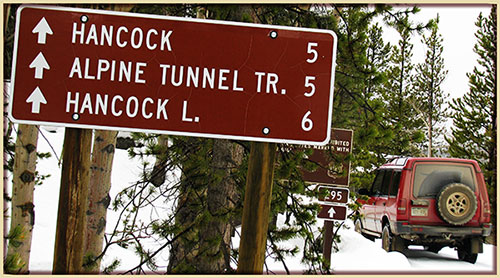 This is
the page for the 2017 Colorado Pass page. You can add to this page and
This is
the page for the 2017 Colorado Pass page. You can add to this page and


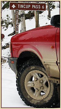 As a guide, you can view the dates and information from the
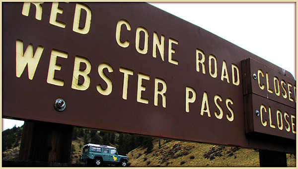
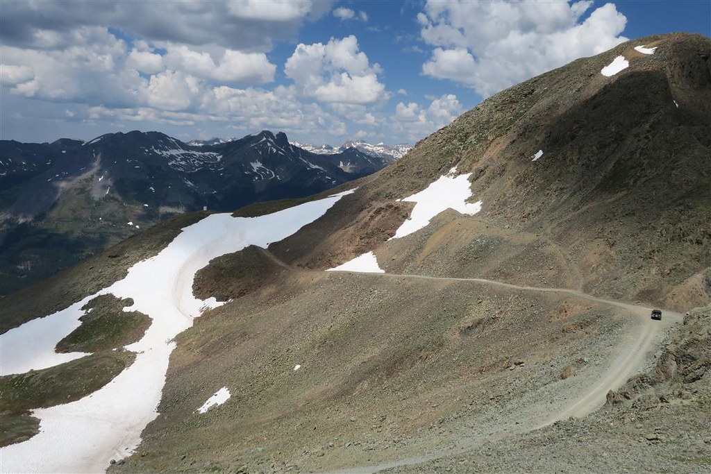