| TRAIL NAME |
NATIONAL FOREST NAME/DISTRICT |
PHONE NUMBER |
STATUS |
DATE UPD. |
Alta Lakes Road
FR623 |
Uncompahgre/Ouray |
970-240-5300 |
|
|
COMMENTS:
|
| |
| Animas Forks |
Uncompahgre/Ouray |
970-240-5300 |
Open |
5/21/13 |
COMMENTS:
|
5/21/14 - Open according to the Forest Service.
12/2/13 - Closed according to the Forest Service. |
Argentine Pass/Waldorf Mine
FR248 |
White River/Dillon |
970-468-5400 |
Open |
7//14 |
COMMENTS:
|
7/18/14 - Trail is open to the top! The one water crossing seemed deep, upto the bottom of my doors in the LR3.
7/4/14 - The trail is still blocked both directions by snow drifts that are fairly large. I'd give it a couple weeks before it is fully passable. You can get to the mine though and still explore some area.
6/21/14 - Trail is open up to about 100 yards from the mine. There is a 50' snow field blocking the road leading up to the mine.
You cannot get to the top of either Argentine or McLellan because of snow. My guess is late July to be open to the top.
6/15/14 - Partially open, can travel 248.1 to the junction of 724.1 but big snowpack areas after that.
Trail is 90% dry with some shallow runoff streams near turnaround point.
6/15/14 - Blocked east of the mine at the switchback. Nothing to do with Montezuma Road. That's not Argentine Pass.
6/10/14 - Montezuma Road is closed until further notice after a flood of the Snake River washed out a 45 foot section of Montezuma Road just west
of Peru Creek Trailhead, prohibiting access to trailheads and roads on national forest land east of the flood site. There will be a temporary emergency bridge
for residents, but this is PROHIBITED for use by recreationalists. Access for the general public is likely to remain closed over summer.
|
| Alpine Tunnel |
San Isabel/Salida |
719-539-3591 |
|
|
COMMENTS:
|
| |
| Ballard Road |
Fort Collins Region |
|
|
|
COMMENTS:
|
| |
| Bangs Canyon |
BLM |
|
|
|
COMMENTS:
|
| |
| Barbour Forks |
White River/Dillon
Pike/South Platte |
970-468-5400
303-275-5610 |
Open |
6/28/14 |
COMMENTS:
|
6/28/14 - Trail open all the way.
Stock SUV's may have a problem with this trail. I have a Jeep Wrangler JK (2-Dr) with a 2.5" lift and 34" tires and had no problem.
6/28/14 - Open all the way. Mostly dry with just a little mud.
|
Billings Lake
CR240 |
Chaffee County |
719-539-6961 |
Open |
6/21/14 |
COMMENTS:
|
| 6/21/14 - Open all the way.
|
| Bill Moore Lake |
Clear Creek |
303-567-3000 |
Open |
7/12/14 |
COMMENTS:
|
7/12/14 - Open all the way.Some mud and still lots of snow to look at, but the trail is finally clear all the way to the lake.
There was only one tight spot that it appears people just snow bashed through a snow drift to make it passable now, but anyone can get by it.
6/29/14 - Bill Moore lake still has large snow drifts preventing you from reaching the lake itself.
Deep snow at the top of Bill Moore Lake. You can drive close enough to hike in.
6/8/14 - No. We got to within about a mile, to the top before it starts
down to the lake. There is one patch where someone tried to go off trail and has
torn up the ground (width of the tracks looks to be 4 wheeler). We made a
barrier of sorts to discourage people from going that direction. The trail
itself has drifts about 6' deep and spots that dip down to where you can see
a little bit of the trail just past where we made it. We walked up a ways
to see if it was possible to get through, but did not continue.
6/8/14 - MHJC members from Patrols 3,8, and 9 went up the trail towards the summit before the downhill part that leads to the lake lake.
Initially, we intended to get there through Red Elephant but took the left forks to get to the Empire Loop/Bill Moore junctions.
The unknown road was very littered throughout especially near a camping area. We cleaned up bottles and cans on some of the trail.
After the loop junction we took 183.1C to go to Bill Moore Lake. We had to snow bash to get to the summit but only two of us made it
past that far. We had a hell of a time locating the trail after that due to 6 foot snow drifts covering the remainder of the trail on the back side
of the summit. We also had to move dead trees over an unauthorized bypass to the snow drifts near the summit where UTVs cut through mud off the trail.
5/3/14 - If you take the complete switchback route at 1.7 miles from the parking lot you are stopped by a 6' off-camber
ice drift at the final switchback. At the time, there was also snow in the rock garden short cut, but we were able to get through that and
it would probably be all gone in there in a week's time. Taking that route we were able to make it 2.7 miles from the parking lot, just past the first split for Mill Creek. |
| Birdseye Gulch |
Uncompahgre/Ouray |
970-240-5300 |
|
|
COMMENTS:
|
| |
Black Bear Pass
FR648 |
Uncompahgre/Ouray |
970-327-4835 |
Open |
9/14/14 |
COMMENTS:
|
9/14/14 - Hallelujah .... Blackbear Pass is now open! The large off camber rock that offered an exciting greeting as you began the downward trek towards Telluride has been neutered! The first few switchbacks are as sharp and narrow as ever, but the lower portion of the trail appears to have been widened a bit! Enjoy!
9/5/14 - Is STILL closed about 1 mile from waterfall.
County is taking their sweet time in removing a rockfall.
9/3/14 - This trail will be closed Sept 3rd and 4th for washout repairs.
7/17/14 - Black Bear Pass was opened all the way through on July 16th. We drove it on July 17th with no problems.
7/9/14 - Should be open now. D5 Cat arrived at top of pass on the morning of the 9th, and had cleared down to the upper bowl by lunch.
Should have been opened to Telluride by 11th. We ran the trail to the top of the pass on the 9th and witnessed all above conditions.
7/5/14 - Black Bear is closed. The forest service is working on opening it this week.
7/5/14 - Open to the summit. Trail is blocked by snow shortly after the summit. There was no crew or equipment so it doesn't appear to be being worked on.
6/29/14 - I called the Ranger Station and they said that they are opening Imogene Pass the weekend of 6/29 amd that Black Bear would follow, potentially being open July 4.
5/27/14 - Closed. Not plowed still has 4 feet of snow at highway.
12/2/13 - Closed according to the Forest Service. |
| Blowout Pass |
Rio Grande/Divide |
|
|
|
COMMENTS:
|
| |
| Bolam Pass |
Uncompahgre/Ouray |
970-240-5300 |
Partially Open |
6/13/14 |
COMMENTS:
|
6/13/14 - You can get a fair way, but there's still too much snow at the top to make it over.
12/2/13 - Closed according to the Forest Service. |
| Boreas Pass |
White River/Dillon |
970-468-5400 |
Open |
7/6/14 |
COMMENTS:
|
7/6/14 - Trail open all the way.Road is in excellent condition.
6/23/14 - Summit County report Boreas Pass is opening today at 10.00am.
6/21/14 - Still closed.
5/10/14 - Still closed.
11/11/13 - Trail was Closed on the Breckenridge side right at the first trail parking lot.
The trail had packed snow/ice. It was obviously recently plowed. |
| Breakneck and Browns Passes (FR175/176) |
Pike/Fairplay |
719-836-2031 |
Open |
6/15/14 |
COMMENTS:
|
| 6/15/14 - Open and passable all the way through. |
Bunce School Trail System
FR115 |
Boulder |
303�541-2500 |
Open |
6/7/14 |
COMMENTS:
|
| 6/7/14 - Gate is open into camp dick. Trail is clear all the way. |
| Calamity Mesa |
BLM Grand Junction |
303-239-3600 |
Open |
4/12/14 |
COMMENTS:
|
| 4/12/14 - The Calamity Mesa Loop is open all the way. We had some trail maintenance to perform to make it that way, so enjoy it.
This is about 20-miles of class 7 trail with 11-named obstacles as well as several unnamed fetes for your pleasure.
33" tires minimum, high clearance, lockers in at least one axle, body armor, a winch, a good camera, and good driving skills minimum recommended.
NO FULL-SIZE VEHICLES! Two obstacles are just barely wide enough for a Jeep JK. (we're talking inches).
Calamity Mesa is southeast of Gateway, CO on the Uncompahgre Plateau. It offers spectacular views and some tough Jeeping.
Figure 4-5 hours just on the 20-mile trail. From Grand Junction, add 1.5 hours each way.
Pictures and a write-up of the Grand Mesa Jeep Club's 2013 Rock Junction can be seen here
This trail is not recommended when wet. Bentonite is common on the trail in some narrow and severely off-camber areas. Bentonite when wet is nearly impossible to drive on and would be extremely dangerous.
|
| California Gulch |
Uncompahgre/Ouray |
970-240-5300 |
Open? |
6/21/14 |
COMMENTS:
6/21/14 - San Juan National Forest says the trail is open and it has been plowed but the trail to the pass is snow covered with several inches of snow a couple of hundred yards beyond the first switchback. I only went a short distance in the snow and then backed down rather than risk getting stuck. It might be possible to make it up but do so at your own risk. There was a plow at the first switchback so I would guess it will be in better condition sometime next week. It won't take much clearing or snow melt and it will be passable.
The trail is wet and muddy below the switchback but no real issues.
12/2/13 - Closed according to the Forest Service.
|
| |
| California Pass |
Uncompahgre/Ouray |
970-240-5300 |
Open |
7/3/14 |
COMMENTS:
7/3/14 - Trail is open all the way, made it through no problem on my BMW R1200GS.
12/2/13 - Closed according to the Forest Service.
|
| |
| Caribou Creek |
Boulder |
303-541-2500 |
|
|
COMMENTS:
|
| |
| Carnage Canyon |
San Isabel/Salida |
719-539-3591 |
Open all year |
|
COMMENTS:
Completely open all year.
|
| |
| Cement Creek Road |
Gunnison/Gunnison |
970-641-0471 |
Open |
7/6/14 |
COMMENTS:
|
7/6/14 - Cement Creek road is open all the way to start of Italian pass.
6/8/14 - Cement creek road is closed by avalanche 1 mile past Dead Man Trailhead. single track is making it through, didn't make it through on 4 wheeler |
| Chalk Mountain |
White River/Holy Cross |
970-827-5715 |
|
|
COMMENTS:
|
| |
| Chihuahua Gulch |
White River/Dillon |
970-468-5400 |
Open |
8/17/14 |
COMMENTS:
|
8/17/14 - Access to the trail via Peru Creek is wide open. There is a temporary passageway. No problem with access, although there might be a short delay at the temporary river crossing over the Snake River.
Trail is just fine.
6/10/14 - Montezuma Road is closed until further notice after a flood of the Snake River washed out a 45 foot section of Montezuma Road just west
of Peru Creek Trailhead, prohibiting access to trailheads and roads on national forest land east of the flood site. There will be a temporary emergency bridge
for residents, but this is PROHIBITED for use by recreationalists. Access for the general public is likely to remain closed over summer. |
| Chinaman Gulch |
San Isabel/Salida |
719-539-3591 |
Open all year |
|
COMMENTS:
Completely open all year.
|
| |
| China Wall |
Pike/Fairplay |
719-836-2031 |
Open all year |
|
COMMENTS:
Completely open all year.
|
| |
| Chinns Lake |
Clear Creek |
303-567-3000 |
Partially Open |
6/25/14 |
COMMENTS:
|
| 6/25/14 - Lower trail (Fall River Reservoir) blocked by 3-4 feet of snow in the very last straight section at the top, should be melted/clear by July 4th weekend. Alternate route to the left is possible with a capable off-road vehicle (lifted, AT/MT tires), tight in a few spots as you're making turns. Top route to Chinns/Sherwin Lakes blocked past big curve by significant snow drift and will probably be 2-3 more weeks.
Bring a fishing pole, fish were hitting within 5-7 feet of shore on the lower lake :-)
|
| Cinammon Pass |
Uncompahgre/Ouray
BLM/Gunnison |
970-240-5300
970-641-0471 |
Open |
14/6/1 |
COMMENTS:
6/20/14 - Trail is open all the way.
14/6/1 - Pass is open with care, but conditions are dangerous, and it is not advisable for folks with little four-wheel drive experience to attempt the pass just yet.
12/2/13 - Closed according to the Forest Service.
|
**
| |
Coney Flats
FR507 |
Boulder |
303-541-2500 |
Open |
6/28/14 |
COMMENTS:
|
| 6/28/14 - Coney Flats, FR507, is open. Gate is open.
comments: 6/28/14 - Drove the Coney Flats road all the way to the Middle St. Vrain road. All of the snow is melted. No flood damage to the road. All of the sink holes are full of water.
|
| Coon Hollow |
BLM Grand Junction |
303-239-3600 |
|
|
COMMENTS:
|
| |
| Corkscrew Gulch |
Uncompahgre/Ouray
BLM/Gunnison |
970-240-5300
970-641-0471 |
Open |
6/12/14 |
COMMENTS:
6/12/14 - Corkscrew Gulch is open.
12/2/13 - Closed according to the Forest Service.
|
| |
Cottonwood Pass
FR209/FR306 |
San Isabel/Salida |
719-539-3591
|
Open |
5/23/14 |
COMMENTS:
|
| 5/23/14 - Open to Traffic,
FR209, 306 Northbound FR 209, 306 Cottonwood Pass (Milemarker 0-27)
Cottonwood Pass is open for the season; weather permitting.
|
| Cumberland Gulch |
Clear Creek |
303-567-3000 |
|
|
COMMENTS:
|
| |
| Cumberland Pass |
San Isabel/Salida |
719-539-3591
|
Open |
6/16/14 |
COMMENTS:
|
| 6/16/14 - Open. |
| Cunningham Gulch |
Uncompahgre/Ouray |
970-240-5300 |
Open |
6/13/14 |
COMMENTS:
6/13/14 - Open according to the Forest Service.
12/2/13 - Closed according to the Forest Service.
|
| |
| Deer Creek |
White River/Dillon |
970-468-5400 |
Open |
7/12/14 |
COMMENTS:
|
7/12/14 - Deer Creek - Sts John loop is open for round trip from Montezuma.
Road generally dry and in good condition, creek crossings not deep. Temporary bridge over Montezuma road washout is one way with red light on a
fairly short cycle. Cars were parked at Peru creek turnoff but we did not go there.
7/7/14 - Deer Creek seasonal gate closed from Montezuma.
6/10/14 - Montezuma Road is closed until further notice after a flood of the Snake River washed out a 45 foot section of Montezuma Road just west
of Peru Creek Trailhead, prohibiting access to trailheads and roads on national forest land east of the flood site. There will be a temporary emergency bridge
for residents, but this is PROHIBITED for use by recreationalists. Access for the general public is likely to remain closed over summer. |
| Democrat Mountain |
Arapaho/Clear Creek |
303-567-3000 |
Open |
6/21/14 |
COMMENTS:
|
| 6/21/14 - Open all the way to the top.
Trail is in good shape. We did not go down the spur towards Silver Gulch.
|
| Devil's Canyon |
White River/Dillon
Pike/South Platte |
970-468-5400
303-275-5610 |
Open |
7/1/14 |
COMMENTS:
|
| 7/1/14 - Trail Open all the way. Trail is in very good condition.
|
| Eagle Rock |
Teller County |
Near Colorado Springs |
|
|
COMMENTS:
|
| |
| Elwood Pass |
Rio Grande/Conejos
San Juan/Pagosa |
719-274-8971
970-264-2268 |
|
|
COMMENTS:
|
| |
| Engineer Pass |
Uncompahgre/Ouray
BLM/Gunnison |
970-240-5300
970-641-0471 |
Open |
7/10/14 |
COMMENTS:
7/10/14 - Yes open all the way. We did Cinnamon to Animas Fork then Engineers with no problem.
Nothing blocked but snow off to the side.
6/12/14 - Drum roll please! ENGINEER PASS is now OPEN!!USE CAUTION PLEASE!! The pass has spring like conditions, there is a lot of snow,
expect run-off especially in the afternoons as the snow melts off.
Please let someone know if you plan to go over this pass and when to expect you back.
6/1/14 - Open to the top on the west side.
12/2/13 - Closed according to the Forest Service.
|
| |
| Fourmile Travel Area |
San Isabel |
719-486-0749 |
Open |
5/26/14 |
COMMENTS:
|
5/26/14 - Trails are all open and completely dry. Creek crossings were a little deep due to the spring snowmelt but we were able to get through
all of them on our ATVs. You'll want to stay either to the left or right of the Fourmile creek crossing on trail 376. There is a bit of
a dip in the middle, with deeper water there.
Creeks will probably be much lower in a couple weeks time.
This is partially open most of the year. |
| Garibaldi Gulch |
White River/Dillon |
970-468-5400 |
Partially Open |
6/26/14 |
COMMENTS:
|
| 6/26/14 - Open to 11,700 feet - nearly to the top.
|
| Geneva Creek |
White River/Dillon
Pike/South Platte |
970-468-5400
303-275-5610 |
Partially Open |
5/31/14 |
COMMENTS:
|
|
5/31/14 - Open about 2/3 of the way up and then large snow drifts. Was able to snow bust a few but a 50 ft drift was too much.
|
| Georgia Pass |
White River/Dillon |
970-468-5400 |
Open |
7/16/14 |
COMMENTS:
|
7/16/14 - Hwy 285 up to Georgia Pass via Michigan Creek Rd - Open all the way. Georgia Pass down to Tiger Rd via South Fork Swan River Rd - Open all the way.
Barricades have been removed at the top of Georgia Pass at the start of South Fork Swan River Rd.
7/7/14 - Coming from Hwy 285 and Jefferson on CR54 the road is open all the way to the top of Georgia Pass.
There is a road block at the top of Georgia Pass where the South Fork Swan River road starts down. The sign says road closed due to Spring runoff.
I spoke to a motorcycle rider that came up that road and he said the gate is open at the bottom and the trail is in good condition. I checked the gate myself on July 7th and yes, the gate is open at the bottom. Not sure why the barricade at the top of Georgia Pass is still there.
6/21/14 - From the Jefferson, CO. side I drove all the way to the top of the pass with no issues. I did not try to go down the Breckenridge,CO. side as there was a lot of snow in the trees and that side of the pass is more shaded from the sun. I was by myself and didn't want to risk it. I am not sure if it is open yet.
Road was dry almost all the way except for e small snow crossing about 1/4 mile from the top, but it does not pose any problems.
|
| Gold Hill/Switzerland Trail |
Boulder |
303-541-2500 |
Open |
5/3/14 |
COMMENTS:
|
5/3/14 - Traveled from Gold Hill Rd South to Sourdough and out to Peak to Peak hwy. Did not travel North of Gold Hill Rd.
Completely clear and dry except for a few whimpy snow remnants heading out toward peak to peak which will be gone in a day two.
Amazing difference from my last report bar a month ago.
3/29/14 - Deep snow. Tried it from the Hwy 72, Sugarloaf road end.
We made it only a couple of 100 yards before stopped by deep snow. There are two layers of crust in the snow pack.
One on top, the second about 12 inches above the dirt. This second layer is very hard and icy. Once you break through both layers you are finished.
Top layer effectively high centers the vehicle. The second layer keeps you from getting any traction.
|
| Governor Basin |
Uncompahgre/Ouray |
970-240-5300
970 |
|
|
COMMENTS:
|
| |
| Green Ridge Road |
Roosevelt National Forest |
970-498-1100 |
|
|
COMMENTS:
|
| |
| Grizzly Lake |
San Isabel/Salida |
719-539-3591
|
Open |
7/16/14 |
COMMENTS:
|
| 7/16/14 - Open all the way except last 100 yards where it is permanently closed.
That first obstacle after the stream crossing right at the start is a Dusy :-)
|
Guanella Pass
CR62 |
White River/Dillon
Pike/South Platte |
970-468-5400
303-275-5610 |
|
|
COMMENTS:
|
| |
| Gunsight Pass |
White River/Sopris District |
970-963-2266 |
Open |
7/25/14 |
COMMENTS:
|
| 7/25/14 - Open to the top. Keep in mind this a dead end trail. The land over the pass is private property.
|
Hackett Gulch
FR220 |
Pike National Forest |
Near Colorado Springs |
Open |
5/17/14 |
COMMENTS:
|
| 5/17/14 - Dry, open and clear. Someone has pulled down the barrier where the
trail is supposed to end. Confirmed with the Forest Service that this area near the river is closed. |
Hagerman Pass
FR105
|
San Isabel/Leadville
White River/Sopris |
719-486-0749
970-963-2266 |
Open |
7/1/14 |
COMMENTS:
|
7/1/14 - : Hagerman Pass is OPEN all the way from Turquoise Lake to Basalt. Someone in a Caterpillar has opened up all drifts and left the big Cat near the summit. You'll get a great pic, if you want, as you travel through the deep snow drift on the Leadville side of Hagerman Pass.
6/23/14 - Hagerman Pass is expected to open the second week in July. The East side of trail is still snow covered. |
| Halfmoon Creek |
San Isabel/Leadville
White River/Sopris |
719-486-0749
970-963-2266 |
Open |
7/21/14 |
COMMENTS:
|
7/21/14 - Open all the way except to gate below Champion Mill. Both South and North forks are pssable.
Depth of first crossing on South is 27-29" for brief moment. Second crossing water is non-issue if you made it past the first.
First crossing on North fork also gets to about 27-29" at the very end. Second North crossing is long but not as deep as first.
7/13/14 -Champion Mill F.S.110 Half Moon Gulch. The gate is locked at the near end of the trail to the mill. Hike uphill to reach the mill.
7/4/14 - South fork is also open all the way to the top.
7/4/14 - North fork yes, Water over 33'' tires easy at both water crossings at this time.
6/21/14 - North Half Moon is open all the way but the water is high. |
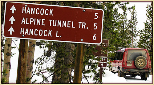
Hancock Pass
FR295 |
San Isabel/Salida |
719-539-3591 |
Open |
9/28/14 |
COMMENTS:
|
9/28/14 - Hancock Pass is open all the way on both sides.
I took Hancock Pass in the morning on my drive from Colorado Springs to Salt Lake City. This is not the most direct route, but added only an hour or so
to the entire drive. The trail is open and clear on both sides. The upper portion of the East side is a slow-going, bone-jarring series of
vehicle-destroying rocks. The upper portion of the West side is a steep dirt track with tight twists that will ruin running boards on a stock vehicle.
I drove in my stock Toyota Tundra Crewmax full-size truck with ordinary tires and running boards. The pass did not present any unsurmountable
difficulties.
7/12/14 - Hancock Pass is open.
6/14/14 - You can get about 1 mile up the pass. |
Hayden Pass
FR970 |
Rio Grande/Saguache
San Isabel/Salida |
719-655-2547
719-539-3591 |
Open |
6/24/14 |
COMMENTS:
|
| 6/24/14 - Open all the way. |
| Hermit Pass |
Rio Grande/Saguache
San Isabel/San Carlos |
719-655-2547
719-269-8500 |
Partially Open |
7/11/14 |
COMMENTS:
|
| 7/11/14 - Trail is NOT open to the top. There is a snowdrift at the last switchback before you reach the pass.
Otherwise the rest of the road is clear and dry. A bit rocky and rough much of the way but very beautiful. photo here. |
| Hidden Valley Trail |
Pike/South Platte |
303-275-5610 |
Opend>
| 5/24/14 |
COMMENTS:
5/24/14 - Hidden Valley, Dakan Road, Missouri Gulch and Illinois Gulch all open all the way. Muddy
over Memorial Day weekend, but nothing unmanagable.
4/13/14 - Still closed, although the sign says open on 1 April.
|
| |
| Holy Cross City |
San Isabel/Leadville
White River/Sopris |
719-486-0749
970-963-2266 |
Open |
6/28/14; |
COMMENTS:
|
| 6/28/14 - Open to the city. Two drifts before Cleveland Rock. Winched through one of them. Other could be winched through as well. Many rigs behind us. Likely they passed through. |
| Hurricane Pass |
Uncompahgre/Ouray |
970-240-5300 |
Open |
7/3/14 |
COMMENTS:
7/3/14 - Trail is Open all the way. I just came via California Gulch and went down via Corkscrew Gulch on my BMW R1200GS, Pass is great!
12/2/13 - Closed according to the Forest Service.
|
| |
Imogene Pass
FR869 |
Uncompahgre/Ouray |
970-327-4835 |
Open |
7/5/14 |
COMMENTS:
7/5/14 - Open all the way through.
7/2/14 - Called the road department and they said for sure 7/3/14. They are removing their equipment today, 7/2/14
6/29/14 - I called the Ranger Station and they said that they are opening Imogene Pass the weekend of 6/29 amd that Black Bear would follow, potentially being open July 4.
6/13/14 - Open to the snow - which is not very far at all.
12/2/13 - Closed according to the Forest Service.
|
| |
Independence Pass
CO82 |
Park County |
|
Open |
7/7/14 |
COMMENTS:
|
| This paved road is traditionally open from Memorial Day |
| Independence Trail |
Canyon City |
|
|
|
COMMENTS:
|
| |
| Iron Chest |
San Isabel/Salida |
719-539-3591
|
Open |
6/21/14 |
COMMENTS:
|
| 6/21/14 - Open to the top. |
| Italian Creek Road/Upper Reno Divide |
Gunnison/Gunnison |
970-641-0471 |
Open |
7/4/14 |
COMMENTS:
|
7/6/14 - the Reno Divide bypass is open, but is narrow and tricky and should be driven by experienced drivers with modified vehicles.
7/4/14 - Open, including American Flag Mountain and Reno Divide bypass. Reno Bypass has a lot of low hanging branches that need to be trimmed.
7/4/14 - Trail is open from both sides. A little snow at the top but it's passable. |
| Jenny Creek Trail |
Clear Creek |
303-567-3000 |
|
|
COMMENTS:
|
| |
| Jones Pass |
Clear Creek |
303-567-3000 |
Open |
9/26/14 |
COMMENTS:
|
9/26/14 - Open all the way. There are moose in the valley on the west side.
8/25/14 - Road is still blocked at the summit from 40. Snowed briefly while I was up there.
8/7/14 - Jones Pass is still blocked by a huge snowdrift at top. Only access to either side is by walking only. I do not see this Pass opening at all in 2014. Trail from Empire side is in good shape.
7/13/14 - Coming from 40: Snow blocking trail at 12,500 ft for trucks, motorcycles can pass on steep side hill. Not sure what else is beyond this blockage.
Ran into snow at about 12,500. Almost passable, saw motorcycles getting around the large patch covering the trail.
7/1/14 - Approach from highway 40. The Pass is still covered with a bunch of snow. you can get to within 2 miles of the top. Only skiers and hikers up there now. Do not know what is on the west side or the Williams Fork side.
Snow and a lot of it above treeline
|
Kebler Pass
CR12 |
Paonia; |
970-527-4131 |
Open |
6/11/14 |
COMMENTS:
6/11/14 - Open according to a climbing website I frequent: Kebler Pass opened at 3.30pm today.
|
| 6/4/14 - Closed. Traveled from the Paonia side, didn't make it halfway up before running into jersey
barrier with chains and locks. Looks like road work is being done above it. |
| Kelly Flats |
Canyon Lakes |
970-295-6700 |
|
|
COMMENTS:
|
| |
| Kendall Peak and Kendall Mountain |
Uncompahgre/Ouray |
970-240-5300 |
|
|
COMMENTS:
|
| |
| Kennebec Pass |
San Juan Public Lands |
970-247-4874 |
Open |
/3/14 |
COMMENTS:
8/3/14 - Open all the way to the top. It's been raining every day, some waterholes and mud, nothing to gnarly.
6/13/14 - Supposedly open all the way.
12/2/13 - Closed according to the Forest Service.
|
| |
Kingston Peak
FR353 |
Clear Creek |
303-567-3000 |
Closed |
7/4/14 |
COMMENTS:
|
7/4/14 - I called the Forest Service office in Idaho Springs and they said the trail is scheduled to open on July 15.
6/15/14 - Trail still has some snow coverage leading to the gate; Seasonal gate still closed coming from Rollinsville, probably another 2-3 weeks until it is passable to even open the gate. |
| Lamartine/Saxon Mountain |
Clear Creek |
303-567-3000 |
Open? |
6/26/14 |
COMMENTS:
|
6/26/14 - Saxon Mountain road is still blocked by a rock slide about 1.6 miles up from the Georgetown side. It is passable by a very experienced driver. A winch might be necessary.
Saxon Mountain is accessible from the east side from Hwy 103. I traveled both Cascade Creek Road and Ute Creek Road and the trails are open all the
way to the top. Cascade Creek is a little muddy.
6/21/14 - Saxon Mountain is passable, but it should be noted that the big rock slide near Georgetown is still in place along with a couple small slides and large boulders further on. Lesser equipped vehicles will have trouble or will not be able to travel all the way through.
6/14/14 - Trail is open all the way. No snow on the trail at all.
Trail is in good condition. fallen trees have been cut and moved. Few muddy spots that are rutted out, but with the correct line, it is
very passable.
4/26/14 - Trail is closed at approximately 1.6 miles from mileage sign
near trailhead. This is a result of a pretty large rockslide and no options exist except returning
to Georgetown. This is not a simple rock in the road, but a project for heavy equipment. |
LaSalle Pass
CR44 |
Pike/Fairplay |
719-836-2031 |
Open |
6/8/14 |
COMMENTS:
|
6/8/14 - Open all the way.
4/20/14 - Could be open all the way. One snowdrift on the north side before you start
the climb to the top. A vehicle or two could punch in and back up a few times to get through and
still stay on the trail just fine. Made the entire ride on a MC without issue.
4/18/14 - Trail is not open for 4wd or ATV travel once in the tree line areas from either side.
Trail is blocked by snow. Was able to get by the edge of the snow drifts on motorcycle
on 4/18/14. Trail should be open for all travel by about 1 May. |
Last Dollar Road
FR638 |
Uncompahgre/Ouray |
970-327-4835 |
Open |
6/10/14 |
COMMENTS:
|
| 6/10/12 - Traveled from Hwy 145 to Hwy 62. Little muddy in a couple of places but no problems getting through. Creek crossings are easy.
|
| Lead King Basin |
White River/Sopris District |
970-963-2266 |
Open |
9/28/14 |
COMMENTS:
|
9/28/14 - Open, dry, colors will peak in 5-7 days I would think.
7/16/14 - Trail is open and dusty and smooth. wild flowers are in full bloom!!!!
6/15/14 - Loop not open due to snow on upper road from Avalanche. But you can get back into Lead king Basin by lower road passed the Mill and town of Crystal.
90% dry 10% wet in areas
|
| Left Hand Canyon |
Boulder |
303-541-2500 |
Closed |
4/1/14 |
COMMENTS:
|
| 4/1/14 - Left Hand Canyon is gated closed and locked with signs stating no access of any kind. There is severe erosion due to last fall's flooding. Word on the street is it will likely remain closed until 2016.
|
| Lime Creek Trail |
Uncompahgre/Ouray |
970-240-5300 |
Open |
6/1/14 |
COMMENTS:
|
| 6/1/14 - Trail is open all the way.
Only 2WD needed. No snow on the road. Some rocks have fallen onto the road in places but they are easily passable.
|
| Loch Lomond |
Clear Creek |
303-567-3000 |
|
|
COMMENTS:
|
| |
Longwater Gulch
FR221 |
Pike National Forest |
|
Open |
5/17/14 |
COMMENTS:
|
| 5/17/14 - Open, dry and clear. |
| Maggie Gulch |
Uncompahgre/Ouray |
970-240-5300 |
Open |
7/13/14 |
COMMENTS:
7/13/14 - Open to the end.
6/13/14 - Partially open until blocked by snow.
12/2/13 - Closed according to the Forest Service.
|
| |
| Mammoth Gulch |
Boulder |
303-65533;541-2500 |
|
|
COMMENTS:
|
| |
Marshall Pass
CR200 |
San Isabel/Salida |
719-539-3591
|
Open |
6/27/14 |
COMMENTS:
|
 6/27/14 - Open all the way.
6/11/14 - I called the Forest Service in Salida today and the ranger told me that the east side of the road could be traveled to the pass, however
not all the way down the other side to Sargents. |
| McAllister Gulch |
White River/Holy Cross |
970-827-5715 |
Open |
7/16/14 |
COMMENTS:
|
| 7/16/14 - Open all the way. |
| Medano Pass |
Rio Grande/Saguache
San Isabel/San Carlos
National Parks |
719-655-2547
719-269-8500
719-378-6399 |
Open |
6/21/14 |
COMMENTS:
|
6/21/14 - Yes open all the way. Dry, dusty with a few wet spots and 1 mud hole that will challenge stock SUV's. Water crossings from 4'' to 16'' deep.
5/18/14 - The trail is open till the fourth creek crossing then it is closed till a trail assessment is completed by USFS West cliff office.
Creek crossings are good...water level is low. 32's on my TJ and halfway my tire. There's been a lot of run off that's change the trail in the trees but I was able to do most of the trail in 2WD.
|
| Metberry Gulch |
Teller County |
|
5/17/14 |
Open |
COMMENTS:
|
| 5/17/14 - Open, dry and clear |
Middle St. Vrain
FR114 |
Boulder |
303-541-2500 |
Open |
6/28/14 |
COMMENTS:
|
6/28/14 - The Middle St. Vrain, FR114, is open. Gates are open.
The Coney Creek crossing has been blown out due to the 2013 flood and is no longer as wide as it was. This is the lower Coney Creek crossing on the Middle St. Vrain 4WD road, not the big crossing at Coney Flats.
The Middle St. Vrain has only seen a small amount of damage from the 2013 flood just up from the parking lot at the entrance.
6/21/14 - The gate is still closed at the Middle St. Vrain trail head.
The cutoff to Coney Creek, FR507, is still snowed in about an eight of a mile up from the Middle St. Vrain 4WD road, FR114.
Plan on reviewing again on June 28th.
6/14/14 - Gate closed at Camp Dick. |
| Mill Creek/Red Elephant Trail |
Arapaho/Clear Creek |
303-567-3000 |
Open |
6/29/14 |
COMMENTS:
|
| 6/29/14 - Open and dry. |
| Miller Rock |
Boulder |
303-541-2500 |
|
|
COMMENTS:
|
| |
| Miner's Gulch |
Clear Creek |
303-567-3000 |
Open with care |
6/14/14 |
COMMENTS:
6/14/14 - Traildamage.com show Miners Gulch as loop of FS roads that include 175.3I, 175.3C, and 709.1. This loop is not completely open. There are snow drifts beginning at the jct of 709.1 and 175.3C for a couple hundred yards. Probably could be broken open but I was solo with no winch.
Historically Miners Gulch was the gulch beginning where 709.1 splits off of 705.1. This quarter mile stretch of 709.1 from 705.1 to 175.3C is very washed out with rivers of water running down it. I made it down, hitting my sliders several times. Don't know if I could have made it up.
|
| |
| Minnie Gulch |
Uncompahgre/Ouray |
970-240-5300 |
Open |
7/13/14 |
COMMENTS:
7/13/14 - Open to the end.
6/13/14 - Partially open to the snow line.
12/2/13 - Closed according to the Forest Service.
|
| |
| Moody Hill |
Canyon Lakes |
970-295-6700 |
|
|
COMMENTS:
|
| |
| Moon/Gamble Gulch |
Boulder |
303-541-2500 |
|
|
COMMENTS:
|
| |
| Mosquito Pass |
Pike/South Park
San Isabel/Leadville |
719-836-2031
719-486-0749 |
Open? |
10/4/14 |
COMMENTS:
|
10/4/14 - : Trail may be open all the way, but we'd advise that drivers turn around at 6 miles in from Leadville. Maybe even better to turn around at 5.5 miles, where there is enough space, and dry road, to turn around.
We started from Leadville at around 11:30am. Road is passable for the first 6 miles. Lots of bumps and wobbles. Oodles of fun.
In the shade there were icy spots and unmelted snow, easy to spot and navigate. And this wasn't even the hard part! The switchbacks get you
higher and the views were clear, with no haze and clear skies. But we could not complete the length of the pass. We started in Leadville.
About 6.0 miles from Ash Street and E 7th St, on the 2nd switchback, road was mostly covered in snow, and we slipped a couple of times trying to
wedge higher to the right on the exposed part of the road. We backed down the road to a dry spot and proceeded to do a 15-point turn to point
us back down the pass. Very bummed that I missed this road this season.
9/25/14 - I drove through on Monday evening 22 Sept. The squeeze between the two largest boulders is a little tight, but the rubble in between wasn't there. Except for wide vehicles, if you can drive the rest of the pass, you can get past the slide. 2003 TJ Wrangler on 33's.
I will say that Mosquito Pass seems a bit more challenging (fun) than in previous years.
9/22/14 - No. 7.6 miles from Leadville side, just uphill from new london mine. Approx 4.4 miles from the trail start and "4 wheel drive only" sign.
Large rockslide, two huge boulders in the trail, multiple small boulders all over. Impassable except for highly lifted, very large tire-d rig.
I have a lifted land cruiser with 33's but was traveling alone so didn't want to chance getting stuck, so went back to Leadville. photo here
9/22/14 - Large rocks have fallen onto the road just above the New London Mine. May be impassable. I was not there but saw pictures.
9/1/14 - Clear all the way, no snow drifts as of this date but we did get snowed on during the day, then right back to sunshine
Rough and rocky but still do able with good clearance.
7/20/14 - Open all the way. Very little snow left on the trail.
7/18/14 - Open all the way. But there is a tricky section just east of the pass where you must squeeze by a snow bank on a tippy slope.
The snow just above North London Mine is easily bypassed (without going into the meadow as some have done :-(
7/13/14 - Open from Alama to North London Mine. 7+ feet snow still blocking road at mine. 200 yards pass the mine there is a small rock slide on the trail.
10+ feet snow blocking road above mine on talus field climb to summit. From Leadville to the summit is open.
Rock slide near North London Mine.
7/9/14 - Open from Alma to North London Mine. Open from Alama to North London Mine. 7+ feet snow still blocking road at mine.
10+ feet snow blocking road above mine on talus field climb to summit. Road muddy and creek crossings high due to snowmelt.
6/21/14 - From Alma the trail is open to the North London Mine.
5/27/14 - Open 1 mile from trailhead on Alma side. Blocked by snow after that. May be able to bash further if you go prepared. |
Mount Antero
FR277/278 |
San Isabel/Salida |
719-539-3591
|
Open |
9/27/14 |
COMMENTS:
|

9/27/14 - The Mount Antero road is open all the way to the high point at 13700 feet.
The road is, as usual, an unrelenting climb over stones and rocks. I have an ordinary full-size pickup, Toyota Tundra Crewmax with ordinary tires
and running boards. Entire road is passable with little difficulty. We stopped driving at 13000 feet and hiked the rest of the way. Beautiful
sunny weather, fantastic fall colors.
7/16/14 - Open all the way. |
| Mount Baldy/Captain Jacks |
Pike National Forest/ El Paso County |
719-836-2031 |
|
|
COMMENTS:
|
| |
| Mount Blanca/Como Lakes |
Rio Grande/Saguache |
719-655-2547 |
Partially open |
8/2/14 |
COMMENTS:
|
| 8/2/14 - Rockslide at N37.57015 W105.52427, about 1 mile above Holbrook Creek crossing
A rockslide at N37.57015 W105.52427, about 1 mile above Holbrook Creek crossing, during the past 5 days. We were warned on the trail by some 4x4's so we took a campsite above Jaws 1 at the Holbrook Creek crossing and hiked the next day. On the hike up we saw ATV's and side-by side's could get through. On the hike down we encountered a Rubicon that had winched over and a stuck Cherokee (no winch). With an hour of handwork by 9 people the Rubicon winched the Cherokee over. Sunday AM a few buggies drove by our camp. Do not know how far they got. That slide could use a day of shovel and pick work by a crew of 10 and the road would be restored. Rest of trail is its usual difficult condition.
|
| Mount Bross |
Pike/South Park |
719-836-2031 |
Open |
7/19/14 |
COMMENTS:
7/19/14 - Open all the way. No sign of any restrictions. The route on the south side was blocked by snow but the northern one was fine.
I did see a "For Sale" sign.
NOTE: Access is in issue for this trail due to private property. Check locally before proceeding.
|
| |
| Mount McClellan |
Arapaho/Clear Creek |
303-567-3000 |
|
|
COMMENTS:
|
| |
| Napoleon Pass |
San Isabel/Salida |
719-539-3591 |
|
|
COMMENTS:
|
| |
| No Name Gulch |
White River/Holy Cross |
970-827-5715 |
|
|
COMMENTS:
|
| |
| North Fork Reservoir Road |
San Isabel/Salida |
719-539-3591 |
Open |
8/17/14 |
COMMENTS:
|
| 8/17/14 - Campground at top is closed; day access is still OK. Trail is rough but passable to a stock 4x4 or high clearance vehicle. Trail to Billings lake remains open and passable to 4x4.
|
| Ohio Pass |
Gunnison |
970-641-0471 |
Open |
9/26/14 |
COMMENTS:
|
| 9/26/14 - Yes open and dusty. Dry, heavy traffic due to fall colors.
|
Ophir Pass
FR630 |
Uncompahgre/Ouray |
970-327-4835 |
Open |
6/6/14 |
COMMENTS:
6/6/14 - West side has been plowed, now open all the way. 200 feet of very shallow melting snow on road just west of summit. 2013 Tahoe had no issues.
5/21/14 - Open to the top on the east side.
5/1/14 - Was open to the top on the east side, but some snow has fallen in the San Juans and status may have changed. Definitely not possible to treat as
a through road yet.
12/2/14 - Closed according to the Forest Service.
|
| |
| Otto Mears Toll Road |
San Isabel/Salida |
719-539-3591
|
Open |
7/3/14 |
COMMENTS:
|
| 7/3/14 - Bonanza area is snow free, including the toll road.
|
| Owl Creek Pass |
Uncompahgre/Ouray
BLM/Gunnison |
970-240-5300
970-641-0471 |
Open |
6/13/14 |
COMMENTS:
6/13/14 - Open all the way. Did with 4WD Jeep. No issues even for 2-wheel.
5/24/14 - Not plowed (Closed) about a mile before the pass from ridgway.
12/2/13 - Closed according to the Forest Service.
|
| |
| Pace Lake Road |
BLM Grand Junction |
303-239-3600 |
|
|
COMMENTS:
|
| |
Peak 9 Trail
FR248 |
White River/Dillon |
970-468-5400 |
Open |
7/16/14 |
COMMENTS:
|
|
7/16/14 - Trail is open all the way to Peak 10 Weather Station and 4th of July Bowl.
There are a few drifts of snow that already have tire tracks in them, so are easy to navigate. Much of last 2 miles have water running down them. Still good traction anyways.
I know it's not a trail you usually follow, but it is a popular Summit County trail to go summer snowboarding. Side note, there's still about 900 vertical feet of snow left in the bowl.
|
| Pearl Pass |
Gunnison/Gunnison |
970-641-0471 |
Closed |
10/4/14 |
COMMENTS:
|
10/4/14 - From the Aspen side, trail is passable up to the tundra, where snow has blown in and blocked the road. Pearl Pass is now closed.
This year we had six weeks of enjoying the pass, can't wait for next year!
9/28/14 - Yes, On 9-28 Sunday there was rain at bottom and snowing at the top. Maybe 1" covered road at very top. Colors on both sides are Great.
Great conditions besides the rain and snow stopped the views on this day.
9/20/14 - Still open. Fall colors are spectacular.
8/15/14 - Open all the way. Last of the snow has melted. The wild flowers are spectacular on the Aspen side just below the boulder field.
8/11/14 - : Pearl Pass is now open.
The Aspen side has been cleared of the last snow blocking the road, about 100yds below the summit.
HOWEVER, a layer of ice is now exposed where the snow had been. There's probably 80' of road with ice covering the entire width of it. Bare rubber tires will not stick to it. Tire chains would help, but safe travel might be expected by next weekend.
Very dangerous 100yds below the summit on the Aspen side due to ice on the road.
Please do not consider leaving the road way. photo here
7/19/14 - From the Aspen side the trail has two snow barriers about a mile from the top of the pass. One was over 400' long and 4' deep. The snow obstacle right near the top looked similarly imposing. I'm not sure this pass will open this summer.
Running lifted Wrangler with 33" tires; so the snow obstacles are real!
7/17/14 - Still blocked by snow on the Aspen side. It may not be passable before September, if at all, this year. I have never seen this much snow, this late in the summer.
7/10/14 - From Crested Butte the pass is driveable with only one snow bank that is difficult to navigate because of it's proximity to the edge of the shelf road (a stock Nissan Frontier made it with a little push). The pass is covered with snow 1/2 mile from the top of the pass, you cannot drive to Aspen or get to Montezuma Basin from the Crested Butte side!
6/24/14 - Open 1/4 mile past the turn off to Montezuma before snow covers the trail. Montezuma Basin is open 1/2 mile past the turn off from Pearl Pass before snow covers the trail.
6/15/14 - From Aspen, Not open. Snow covers the trail just before the turnoff to Montezuma Basin. |
| Peru Creek Road |
White River/Dillon |
970-468-5400 |
Closed |
6/10/14 |
COMMENTS:
|
| 6/10/14 - Montezuma Road is closed until further notice after a flood of the Snake River washed out a 45 foot section of Montezuma Road just west
of Peru Creek Trailhead, prohibiting access to trailheads and roads on national forest land east of the flood site. There will be a temporary emergency bridge
for residents, but this is PROHIBITED for use by recreationalists. Access for the general public is likely to remain closed over summer. |
| Picayune/Placer Gulch |
Uncompahgre/Ouray |
970-240-5300 |
Open |
7/12/14 |
COMMENTS:
7/12/14 - Open all the way and dry.
6/13/14 - Still closed.
12/2/13 - Closed according to the Forest Service.
|
| |
| Pickle Gulch |
Arapaho/Clear Creek |
303-567-3000 |
Open |
7/13/14 |
COMMENTS:
|
7/13/14 - Trail is open all the way. Still some mud puddles, but all can be run. The previous difficult washout sections have been worn down to
where they are more doable and put the trail back in range for nearly any lifted, low 4x4 vehicle.
5/31/14 - The trail is open, however you can only go about a mile or so in.
It is very washed out along the way from the very beginning of the trail, and there is lots of water and mud. It is no longer an easy trail based
on what the Trail Damage website lists it as. At about a mile there is still snow banks blocking the trail, and we tried winching through the first
few but then turned around because they continued to get bigger.
4/19/14 - Made it only half a mile before the snow finally stopped us on an uphill section just past the rock garden with the bypass.
The whole half mile was deep, wet, snow.
|
| Pinyon Mesa |
|
|
|
|
COMMENTS:
|
| |
| Pole Hill |
Canyon Lakes |
970-498-2770 |
Open |
6/21/14 |
COMMENTS:
|
| 6/21/14 - Yes, open. One short segment (247D) fenced off.
Good condition, dry
|
Pomeroy Lake
FR297 |
San Isabel/Salida |
719-539-3591 |
Open |
6/26/14 |
COMMENTS:
|
| 6/26/14 - Open to the top. |
| Poughkeepsie Gulch |
Uncompahgre/Ouray |
970-240-5300 |
Open |
7/11/14 |
COMMENTS:
7/11/14 - The trail is open all the way - I traversed it from North (intersection with Mineral Creek trail) to South (coming out at Lake Como)....
The trail is very wet so the difficult areas are a little more so due to tires getting muddy and having less traction....
This is very noticeable at the "wall" and the difficult sections above the "wall". Lifted vehicles with good traction
along with experienced drivers should make it with little trouble.
6/22/14 - Coming up from Mineral Crk trail (southerly) the gate is open. The trail from Mineral Creek trail up to the gate is good.
Lots of snow on the trail above the gate. Gave up at about 1/4 mile South of the gate.
6/19/14 - Closed. Sign on gate says closed until June 30.
6/14/14 - Still closed.
12/2/13 - Closed according to the Forest Service.
|
| |
| Ptarmigan Pass |
White River/Holy Cross |
970-827-5715 |
Open |
7/16/14 |
COMMENTS:
|
7/16/14 - Open all the way.
6/28/14 - We entered from Shrine Pass Road, the creek is high and there were several snow drifts we busted, got to the top of the mountain and had to stop when the drift was 5 feet tall. The snow is SOFT, it should melt fast. There were rigs on the top of the mountain from the Camp Hale side. |
| Radical Hill |
White River/Dillon |
970-468-5400 |
Open with care |
7/20/14 |
COMMENTS:
|
7/20/14 - I traveled up Radical Hill right after those three Jeeps came down. There is one tricky part right at the mine where snow partly covers the trail, but everything else was fine all the way to top.
7/20/14 - I witnessed (from the top looking down) three Jeeps successfully travel down Radical Hill.
There is still snow at the top but the Jeeps were able to get through with a spotter. I personally thought one of the Jeeps was going to roll off the trail. I was NOT going to try it. This trail is passable but you better have a spotter until the snow melts completely.
7/18/14 - Not open yet, snow still blocking trail near the top. Maybe another week?
7/7/14 - Trail is still blocked in two places with snow. First snow block appears to be about 3/4 the way up and the other snow block is at the very top. This is seen from Webster Pass. There is no snow west of Radical Hill as seen from Saints John Rd.
|
| Rampart Range |
Pike/South Platte |
303-275-5610 |
Open |
6/21/14 |
COMMENTS:
6/21/14 - Rampart Range Road is now open. Dry and normal road surface conditions
4/13/14 - Still closed.
|
| |
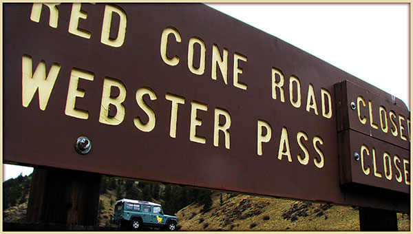
| Red Cone |
White River/Dillon
Pike/South Platte |
970-468-5400
303-275-5610 |
Open |
7/20/14 |
COMMENTS:
7/20/14 - Clear all the way.
7/7/14 - Snowdrift on Handcart Gulch can be bypassed by using Red Cone. Red Cone appears to be free of snow. I spoke to a small ATV rider that rode Red Cone and he said the trail is open.
|
7/4/14 - Gates are open on both ends. Summit County is allowing public access through Montezuma.
6/28/14 - Trail has been cleared, however the gates remain closed until Webster Pass fully clears, or the Summit County Sheriff allows public access through the montezuma road closure.
6/2/14 - Gated shut until the spring run-off finishes and the Mile-Hi Jeep Club can clear the trail.
5/2/14 - Seasonal Gate will remain closed till Mile-Hi Jeep Club can clear the trail. Tentative opening is July 4th weekend. |
| Red Canyon Park |
Canyon City |
|
|
|
COMMENTS:
|
| |
| Rollins Pass - East Side |
Roosevelt/Boulder |
303-541-2500 |
Partially Open |
7/19/14 |
COMMENTS:
|
7/18/14 - From Moffat Tunnel it is still blocked just above Yankee Doodle Lake by about three feet of snow.
6/7/14 - Trail is blocked by snowdrifts about 4.5 miles in from the start near East Moffet Tunnel.
Easy going until about 4.5 miles then snowdrifts block the road. Some guys punched/winched through but eventually got stopped another 0.5 miles
beyond the first drifts. Hiked the rest of the way along the road to Yankee Doodle Lake (40% of which was hiking over deep snow).
Several drifts in areas topped 7 feet. Probably going to be while yet until access to Jenny/Yankee Doodle Lake is unobstructed.
6/1/14 - No, trail is blocked by deep snow 3.4 miles from the trail head. Give it 2 or 3 weeks... |
| Rollins Pass - West Side |
Arapaho/Sulphur |
970-887-4100 |
|
|
COMMENTS:
|
| |
| Red and White Mountain |
White River/Holy Cross |
970-827-5715 |
|
|
COMMENTS:
|
| |
| Saints John |
White River/Dillon |
970-468-5400 |
Open |
7/12/14 |
COMMENTS:
|
7/12/14 - Deer Creek - Sts John loop is open for round trip from Montezuma.
Road generally dry and in good condition, creek crossings not deep. Temporary bridge over Montezuma road washout is one way with red light on a
fairly short cycle. Cars were parked at Peru creek turnoff but we did not go there.
7/7/14 - The temporary bridge to Montezuma is open to the public. Traffic is single lane only with a temporary traffic light. Wait times to cross bridge can be up to three (3) minutes.
Deer Creek seasonal gate is CLOSED from Montezuma.
Saints John is open all the way to the top. There are a few shallow water crossings and the trail is mostly dry.
At the top of Saints John Road I took Middle Fork Swan River Road down. As you start down from the top there is still snow is two places on
Middle Fork Swan River Road. The first snow spot is easily passable but the second snow spot requires you to guess where you think the trail goes
around the snow. There are multiple trails and knowing which one is the official trail is difficult. I would NOT recommend taking this trail until
the snow melts completely and you can stay on the original trail. If you look at this section of the trail on Google Earth you can see multiple
trails in this area.
6/10/14 - Montezuma Road is closed until further notice after a flood of the Snake River washed out a 45 foot section of Montezuma Road just west
of Peru Creek Trailhead, prohibiting access to trailheads and roads on national forest land east of the flood site. There will be a temporary emergency bridge
for residents, but this is PROHIBITED for use by recreationalists. Access for the general public is likely to remain closed over summer. |
| Santa Fe Peak |
White River/Dillon |
970-468-5400 |
Open |
7/7/14 |
COMMENTS:
|
| 7/7/14 - Trail open all the way to the top.
Public access via the temporary bridge west of Montezuma is open. This road is single lane only with temporary traffic light. Wait times can be as much as three (3) minutes.
Trail dry and in good condition. Tippy in spots above the tree line.
|
| Saran Wrap |
Pike National Forest |
Near Colorado Springs |
|
|
COMMENTS:
|
| |
| Schofield Pass |
White River/Sophris District |
970-963-2266 |
Open |
9/27/14 |
COMMENTS:
|
9/27/14 - Yes, trail is in great shape, open and dry. Someone cut back the willow bushes at the top after the stream crossing and widened the trail,
at least enough for Jeeps to get past. It was needed very bad.
9/20/14 - Still open. Fall colors are spectacular.
9/13/14 - Clear all of the way from Crested Butte to Marble.
7/20/14 - All clear from Crystal to Crested Butte.
7/9/14 - Open . Traveled from marble to crested butte. Small snow patch is still there but doable with careful tire placement. Give it a couple more nice days and the snow will most likely be gone.
7/5/14 - Schofied is open. I went from Gothic to Cystal. There is one snow patch about 10 feet long. I dug it out. I don't know that I would go from Crystal to Gothic still, given the width of the trail and it being up hill in that direction. A little more shoveling could remove the drift all together.
6/29//14 - Still had a small snow bridge before the punchbowl, should be cleared by the 4th. Rock slide was cleared up.
6/17/14 - Not passable. I drove in from Marble. While the rock slide can be driven over, a large snow drift covers the trail just above the bottom of the Punchbowl.
6/15/14 - Not open. Very Large rock slide closed road 1 mile above the town of Crystal.
|
| Scotch Creek |
Uncompahgre/Ouray |
970-240-5300 |
Open |
6/13/14 |
COMMENTS:
6/13/14 - Now open.
6/1/14 - Open to the snowline.
12/2/13 - Closed according to the Forest Service.
|
| |
| Sevenmile |
San Isabel/Salida |
719-539-3591 |
Open all year |
|
COMMENTS:
Open all year.
|
| |
| Shrine Pass |
White River/Holy Cross
White River/Dillon |
970-827-5715
970-468-5400 |
|
|
COMMENTS:
|
| |
| Sidney Basin |
Uncompahgre/Ouray |
970-240-5300
970 |
|
|
COMMENTS:
|
| |
| Slate River Road/Paradise Divide |
|
|
Open |
7/18/14 |
COMMENTS:
|
| 7/18/14 - Open the whole way. Went up Washington Gulch (FR811), over Paradise Divide, over Schofield Pass, through Gothic back into Crested Butte.
There are a few rutted-out water crossings which would probably be too much for passenger cars, but 4WD is not required anywhere. Wildflowers are beautiful.
|
| Slaughterhouse Gulch |
Pike/South Platte |
303-275-5610 |
Open |
5/3/14 |
COMMENTS:
|
5/3/14 - It was open all the way with only a couple of very small patches of snow, but otherwise dry.
4/5/14 - Trail is not open all the way due to snow. We made it past the fork and considerably farther to the left.
Map of open trail is
here. The snow has layers. Soft sugar like snow wedged between layers of ice. Some layers of ice were as big as 3 inches thick.
According to the forest service, this trail is open all year. |
| Slide Lake |
White River/Holy Cross |
970-827-5715 |
|
|
COMMENTS:
|
| |
| Spring Creek |
Arapaho/Clear Creek |
303-567-3000 |
Open |
6/28/14 - Clear all the way. No Snow. |
COMMENTS:
|
| |
| Stony Pass |
Uncompahgre/Ouray |
970-240-5300 |
Open |
7/09/14 |
COMMENTS:
7/9/14 - The pass is open all of the way. There is still snow at the top, but the trail is not imparted. Pole Creek was not high, and passable. However, we forded the creek about 11 am.
The lower part of the trail, coming from Hwy 149 was quite rough in spots, but we had not problem. All in our party however were in lifted jeeps.
6/13/14 - Open as far as the Pole Creek crossing, which is running very high.
12/2/13 - Closed according to the Forest Service.
|
| |
Summitville Trail
FR250, FR330, FR380 |
Rio Grande/Conejos
| 719-274-8971 |
|
|
COMMENTS:
|
| |
| Swan River Road - Middle Fork |
White River/Dillon |
970-468-5400 |
Partially Open |
7/20/14 |
COMMENTS:
|
7/20/14 - Middle Fork Swan River Rd is partially open. It has snow blocking part of the trail near the top. I saw Jeeps getting around the snow by driving on a CLOSED part of the trail. :-( Maybe another week or so for snow to melt to SEE actual trail.
6/28/18 - After turning right at the old cabin and crossing the river, I was only able to make it 2/10's of a mile up the hill before being forced to turn around due to snow. |
Swan River Road - North Fork & Wise Mountain
FR354 |
White River/Dillon |
970-468-5400 |
Open |
7/20/14 |
COMMENTS:
|
7/20/14 - North Fork Swan River Rd is open all the way.
6/28/18 - After turning right at the old cabin and crossing the river, I was only able to make it 2/10's of a mile up the hill before being forced to turn around due to snow. |
| Swan River Road - South Fork |
White River/Dillon |
970-468-5400 |
Open |
7/20/14 |
COMMENTS:
|
7/20/14 - Open all the way.
6/28/18 - After turning right at the old cabin and crossing the river, I was only able to make it 2/10's of a mile up the hill before being forced to turn around due to snow. |
Taylor Mountain
CR228/FR330 |
Chaffee County |
719-539-6961 |
Open |
6/29/14 |
COMMENTS:
|
| 6/29/14 - Open all the way. |
| Taylor Pass |
Gunnison/Gunnison |
970-641-0471 |
Open |
9/20/14 |
COMMENTS:
|
9/20/14 - Still open. Fall colors are spectacular.
7/14/14 - Pass is dusty,fun and rough. Creek is not bad. Traveled both directions on Taylor side. took 90 minutes to come back down.
7/4/14 - The big snow drift on top of the pass has melted where the road is, and is passable.
Trail is dry and dusty. The river crossing on the Taylor Park side is vary difficult.
|
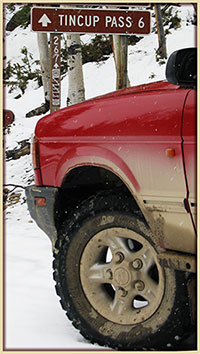
Tincup Pass
FR267 |
San Isabel/Salida
Gunnison/Gunnison |
719-539-3591
970-641-0471 |
Open |
9/20/14 |
COMMENTS:
|
9/20/14 - Still open. Fall colors are spectacular.
9/11/14 - After reading the post per 9/01/14 I inquired to the Saint Elmo General Store
for verification. As I couldn't see them closing this major loop route before the
Buena Vista Color Tour takes place. They verified Tin Cup is indeed OPEN.
9/1/14 - Trail is open all the way as of this date.
We traveled from the St Elmo side up to the summit road is rough but was done in 2WD in a FJ Cruiser. Once at the Summit the remainder of the
trail down to Tin Cup is extremely rough and rocky. Still completed in 2wd and gravity. After Mirrow Lake it is a nice drive down into Tin Cup.
BE ADVISED Tin Cup closed for services as of 1 Sept 2014 till next season.
7/20/14 - Open all the way. Snow on east side is now cleared enough for a Jeep.
7/18/14 - Great condition, some snow off the side of road just below the pass on the St Elmo side but wide open and clear.
7/13/14 - The trail is now passable on the St. Elmo side with motorcycles and 4-wheelers. Path is approximately 3' wide at this point.
7/7/14 - Pass is open all the way to the top on the Tincup side. 25-35 yards of snow blocking the way down on St. Elmo side.
Still deep and thick ice. 37s and locked all the way around and wouldn't even attempt. assuming another 2 weeks till it opens up.
7/4/14 - Partially open. Snow blocking last 25 yards at top of St. Elmo side.
6/21/14 - From St. Elmo the trail is open to just passed the switchbacks about 1/4 mile from the top.
Small snow drift to cross just before the meadow.
6/14/14 - You can get as far as the meadow. |
| Tomichi Pass |
Gunnison/Gunnison |
970-641-0471 |
Closed |
9/11/14 |
COMMENTS:
|
9/11/14 - Tomichi Pass however is CLOSED due to a major Rock Slide.
7/12/14 - Tomichi Pass is open. |
| Treasure Mountain Loop |
Uncompahgre/Ouray |
970-240-5300 |
Closed |
12/2/13 |
COMMENTS:
12/2/13 - Closed according to the Forest Service.
|
| |
| Twin Cone |
Pike, South Platte |
719-836-2031 |
Open |
6/14/14 |
COMMENTS:
|
6/14/14 - to the top. No snow anywhere on the trail.
5/10/14 - It's not closed, but for the most part it's impassible due to deep snow. We were able to make it about a mile and a half in the snow fighting most of the way until we hit snow we couldn't get through.
About 3 miles in the snow was too deep to continue. Was about 2ft up to that point for a good amount of the route while in the trees.
4/27/14 - Closed. There has been a seasonal gate installed with no posted opening date. |
| Uncompahgre Plateau Area |
Grand Valley |
970-242-8211 |
|
|
COMMENTS:
|
| |
| Wager Gulch |
Uncompahgre/Ouray
BLM/Gunnison |
970-240-5300
970-641-0471 |
Open |
6/15/14 |
COMMENTS:
|
|
6/15/14 - Open to at least Carson Ghost Town. (We did not go further)
Some fairly large rocks have slid onto trail about 0.5 mile up. Difficult to get around but rest of trail is clear. (4x4 Tahoe and Jeep made it)
|
| Warden Gulch |
White River/Dillon |
970-468-5400 |
|
|
COMMENTS:
|
| |
| Wearyman Creek (FS747) |
White River/Holy Cross |
970-827-5715 |
Open |
7/16/14 |
COMMENTS:
|
7/16/14 - Open all the way.
6/28/14 - Approached from Shrine Pass Road side, great condition, high water but blocked trail near free line. Endless site line of 4 feet deep snow. |
| Webster Pass/Handcart Gulch |
White River/Dillon
Pike/South Platte |
970-468-5400
303-275-5610 |
Open |
9/25/14 |
COMMENTS:
|
9/25/14 - Road open all the way over.
Left Salt Lake City alone at 11:30 am on way to Denver. Came over via Steamboat Springs, down to Keystone. Got up Webster Pass after sunset,
so decended East side in the dark. Road is easily passable in my stock 2007 Toyota Tundra Crewmax full size pickup with ordinary tires and running boards.
There is an impassable large snow drift about 20 yards south from Webster Pass on Handcart Gulch Rd. Handcart Gulch Rd is open from Hwy 285by besides those. Dropping down the 285 side of the pass there is still a giant snow cornice blocking access. Lower portions look clear.
6/30/14 - Gate remains closed on the Summit County Side (Montezuma). There is no gate on the Grant side of the pass, and it is passable to the start of the switchbacks. Lots of snow beyond that point.
6/28/14 - From the Grant side, I was able to get to the first clearing where you finally get a good look at the switchbacks. I probably could have gone further, but since I was by myself and don't have a winch, I didn't risk it. There is still quite a bit of snow on the mountain. Couldn't see the trail from the last switchback to the top of the pass.
6/10/14 - Montezuma Road is closed until further notice after a flood of the Snake River washed out a 45 foot section of Montezuma Road just west
of Peru Creek Trailhead, prohibiting access to trailheads and roads on national forest land east of the flood site. There will be a temporary emergency bridge
for residents, but this is PROHIBITED for use by recreationalists. Access for the general public is likely to remain closed over summer.
5/31/14 - Still a great deal of snow in deep drifts. Made it about a half mile up the trail from where Red Cone and Webster split.
4/27/14 - Closed. Very deep snow. Couldn't even make it to Hall Valley Campground. |
Weston Pass
CR7 |
Pike/Fairplay
San Isabel/Leadville |
719-836-2031
719-486-0749 |
Open |
6/17/14 |
COMMENTS:
|
06/17/14 - Open all the way through. Ruby and Gold Basin are also fully passable.
6/1/14 - Open on the east side of the pass up to the summit. Mud puddles on parts of the trail, a few washouts, big snowdrift near the top with bypass
(which may not be official). Just past the top of the pass, the snow gets too deep for travel. |
| Wheeler Geological Area |
Rio Grande/Conejos
| 719-274-8971 |
|
|
COMMENTS:
|
| |
| Wheeler Lake |
Pike/South Park |
719-836-2031 |
Open |
7/19/14 |
COMMENTS:
|
7/19/14 - Open all the way. No problems.
7/5/14 - The trail is 95% open. About 1/2 to the top we busted out a large snow drift. About 300 feet from the top is a large deep snow drift that we were only able to get about 20 feet or so into.
There is a lot of waterholes because of runoff but the trail is passable.
I expect that the top section needs another week or 2 and it will be open as well.
5/10/14 - Not open at all. Called the Ranger station the day before was told it was open, it was not. Walked in, trail still has a good amount of snow.
|
| Williams Pass |
San Isabel/Salida |
719-539-3591 |
|
|
COMMENTS:
|
| |
| Wurts Ditch Road |
White River/Holy Cross |
970-827-5715 |
|
|
COMMENTS:
|
| |
| Yankee Boy Basin |
Uncompahgre/Ouray
BLM/Gunnison |
970-240-5300
970-641-0471 |
Open |
6/16/14 |
COMMENTS:
6/16/14 - Open all the way.
5/27/14 - Trail open past twin falls. Trail was plowed further. Road in to lower camp Bird is ok but not plowed past mining operation.
Wet and some light mudding. Snow pack around tree line 4 to 6 feet. We turned around above the falls.
12/2/13 - Closed according to the Forest Service.
|
| |
| Yankee Hill |
Arapaho/Clear Creek |
303-567-3000 |
Open |
6/14/14 |
COMMENTS:
6/14/14 - Trail is open except for one large drift near the top. The drift is on 175.1, but it can be easily bypassed by taking the jct from either side that says to 271.1(various letters). At each jct on 271.1 take the Northern option. This will parallel 175.1 on the South and taken you back to 175.1.
|
| |
|
|
|
|
 This is
the page for the 2014 Colorado Pass page. You can add to this page and
This is
the page for the 2014 Colorado Pass page. You can add to this page and


 As a guide, you can view the dates and information from the