| TRAIL NAME |
NATIONAL FOREST NAME/DISTRICT |
PHONE NUMBER |
STATUS |
DATE UPD. |
Alta Lakes Road
FR623 |
Uncompahgre/Ouray |
970-240-5300 |
Open |
6/29/13 |
COMMENTS:
6/29/13 - Road open all the way. Clear and easy.
|
| |
| Animas Forks |
Uncompahgre/Ouray |
970-240-5300 |
Open |
5/12/13 |
COMMENTS:
5/12/13 - Open all the way to Animas Forks. Water running down the road as well as quite muddy.
4/27/13 - Trail is open all the way to Animas Forks, but we only went to the Picayune Gulch turnoff.
Trail is wet is numerous areas, water running in road, but easy to make it up. It is narrow in places, they only plowed one side.
|
| |
Argentine Pass/Waldorf Mine
FR248 |
White River/Dillon |
970-468-5400 |
Open |
7/6/13 |
COMMENTS:
7/6/13 - Yes the trails thru this area are in great shape BUT don't take the farthest trail to the north
(the shelf road that overlooks I-70). You can't see the huge snow bank until you're about 1/4 mile down the road.
I turned around but that process is not for the fainthearted & it's a long way to back up. The snow bank
is deep enough that I doubt it will be open this summer.
6/29/13 - Open all the way, 1 or 2 small snow drifts off the side of the trail.
Great condition 98% dry but some wet sections. Perfect and not very dusty on the June 29th.
6/2/13 - On the Georgetown side, I made to the fork that divides Argentine Pass from McLellan Mountain.
Some snow to drive on but its hard packed and had little problem with it. some running water. It got deep,
but still, not that bad.
5/25/13 - Made it to about 1/2 past the initial switchbacks before being blocked by snow.
Blocked at about 2/3 of a mile before the first mine. Looks like it should be open to the mine in a couple of weeks.
|
| |
| Alpine Tunnel |
San Isabel/Salida |
719-539-3591 |
Open |
6/13/13 |
COMMENTS:
6/13/13 - Trail is open from the Pitkin side. Several nice history signs installed along the road. Signs were installed, by volunteers Aug 2012. They have interesting info and history of the area.
6/1/13 - The trail is open to mile marker 5, can take 4 wheeler to mile marker 8.5. Snowed in after that.
5/4/13 - The forest service gate right outside of Pitkin will be closed until 5/30. This gate also blocks access to the alpine tunnel.
5/9/13 - Fresh wet snow at the start of the trail. No one has tried yet.
|
| |
| Ballard Road |
Fort Collins Region |
|
|
|
COMMENTS:
|
| |
| Bangs Canyon |
BLM |
|
|
|
COMMENTS:
|
| |
| Barbour Forks |
White River/Dillon
Pike/South Platte |
970-468-5400
303-275-5610 |
Open |
7/27/13 |
COMMENTS:
7/27/13 - Open and passable.
|
| |
Billings Lake
CR240 |
Chaffee County |
719-539-6961 |
Partially Open |
5/26/13 |
COMMENTS:
5/26/13 - Bashed trail open for 10.8 miles before running into giant snow field, losing the trail. Maps say lake is at 11.2 miles.
|
| |
| Bill Moore Lake |
Clear Creek |
303-567-3000 |
Open |
9/14/13 |
COMMENTS:
 9/14/13 - The trail was open all the way on Sept 14. Stock Jeep Wranglers could make the trip.
In general the trail is OK, but about one mile from the start, a large 20 foot deep washout is forming, crossing two thirds of the road. While the rain was coming down on Sept 14, we were watching the washout consume more of the road. 9/14/13 - The trail was open all the way on Sept 14. Stock Jeep Wranglers could make the trip.
In general the trail is OK, but about one mile from the start, a large 20 foot deep washout is forming, crossing two thirds of the road. While the rain was coming down on Sept 14, we were watching the washout consume more of the road.
6/26/13 - Open all the way to the lake! No snow at all.
Fallen trees and any other debris on trail has been taken care of.
6/22/13 - Open all the way.
6/14/13 - Made it 4.8 miles from staging parking lot up until hitting too much snow.
Trail condition was great, up until snow line. Too many people going off trail to get around snow
as you near 4.5 miles, lame.
6/1/13 - Not open to the lake yet. Made it 3 miles from the ATV staging area. Lots of deep snow at tree line.
|
| |
| Birdseye Gulch |
Uncompahgre/Ouray |
970-240-5300 |
Open |
6/30/13 |
COMMENTS:
6/30/13 - Open all the way. Wet and muddy in spots but no other issues.
|
| |
Black Bear Pass
FR648 |
Uncompahgre/Ouray |
970-327-4835 |
Open |
6/29/13 |
COMMENTS:
6/29/13 - Confirming also that trail is open and in good shape all the way over.
Very few wet spots. Almost completely dry.
6/29/13 - Trail open all the way.
6/27/13 - Still blocked by snow at the top.
6/6/13 - Open to the summit on the Ouray side. Just plowed and some of the road has been reworked.
Very wet and soft in places. Do not attempt without very capable vehicle/driver.
5/22/13 - Forest Service's best estimate for opening is mid July.
5/8/13 - Closed by snow and ice.
|
| |
| Blowout Pass |
Rio Grande/Divide |
|
|
|
COMMENTS:
|
| |
| Bolam Pass |
Uncompahgre/Ouray |
970-240-5300 |
Open |
6/27/13 |
COMMENTS:
6/27/13 - Open.
6/1/13 - Open to the snow at the top.
|
| |
| Boreas Pass |
White River/Dillon |
970-468-5400 |
Open |
6/26/13 |
COMMENTS:
6/26/13 - Open all the way.
5/8/13 - trail is gated closed at Roberts Cabin. Scheduled to open June 16.
|
| |
| Breakneck and Browns Passes (FR175/176) |
Pike/Fairplay |
719-836-2031 |
Open |
6/21/13 |
COMMENTS:
6/21/13 - Traveled both complete trails with no snow, mud or road closures.
|
| |
Bunce School Trail System
FR115 |
Boulder |
303�541-2500 |
Open |
6/2/13 |
COMMENTS:
6/2/13 - Yes open from both ends and in great shape.Trail is wet in some areas but very dry everywhere else.
Both gates are open.
5/19/13 - Open all the way from the school side. Gate still closed on the camp dick side but it could be open.
There was no snow at all. Some water holes. Dry and dusty already. Dry to the top of the ironclads as well.
|
| |
| Calamity Mesa |
BLM Grand Junction |
303-239-3600 |
Open |
5/4/13 |
COMMENTS:
5/4/13 - Members of the Grand Mesa Jeep Club pre-ran the Calamity Mesa Loop to make
sure it was open for our Rock Junction event May 29, 30, and 31.
As a Class 6+ or 7 trail, this 20-mile loop is a great day of Jeeping.
Your face will hurt by days end from the day-long smile.
11 named obstacles and many lesser ones keep you engaged and the awesome views will
make your camera blink.
|
| |
| California Gulch |
Uncompahgre/Ouray |
970-240-5300 |
Open |
6/2/13 |
COMMENTS:
6/2/13 - Open and easy. Still wet from snow melt at the high end of the gulch.
|
| |
| California Pass |
Uncompahgre/Ouray |
970-240-5300 |
Open |
6/2/13 |
COMMENTS:
6/2/13 - Narrow for passing in places because of the bulldozer path. Some of the switchbacks
seem steeper than I remember. I think the bulldozer cut some corners tight causing them to be steep.
On the side of the pass closer to Hurricane Pass I ran across a man in a Subaru trying to get to California Pass.
He backed down and headed back over Hurricane Pass. As I headed that way I didn't see how he
made it that far and he might as well continued over California Pass.
6/1/13 - Open according to the Forest Service.
|
| |
| Caribou Creek |
Boulder |
303�541-2500 |
Open |
7/2/13 |
COMMENTS:
7/2/13 - Open according to the Forest Service.
6/2/13 - All gates still closed.
|
| |
| Carnage Canyon |
San Isabel/Salida |
719-539-3591 |
Open all year |
|
COMMENTS:
Completely open all year.
|
| |
| Chalk Mountain |
White River/Holy Cross |
970-827-5715 |
Open |
7/5/13 |
COMMENTS:
7/5/13 - Completely open and snow-free and dry. We were pre-running
trails in the area in preparation for All-4-Fun at the end of the month and everything in the area is now open.
Wildflowers are also in full bloom, including amazing amounts of Columbines. :)
|
| |
| Chihuahua Gulch |
White River/Dillon |
970-468-5400 |
|
|
COMMENTS:
|
| |
| Chinaman Gulch |
San Isabel/Salida |
719-539-3591 |
Open all year |
|
COMMENTS:
Completely open all year.
|
| |
| China Wall |
Pike/Fairplay |
719-836-2031 |
Open all year |
4/10/13 |
COMMENTS:
Completely open all year.
4/10/13 - Clear and clean! No mud. Really dry and dusty
|
| |
| Chinns Lake |
Clear Creek |
303-567-3000 |
6/30/12 |
Open |
COMMENTS:
6/30/13 - Trail is now open to second lake. Went last week, and only open to 1st lake. But now, open all the way.
6/9/13 - Chinns is blocked by snow,had to back down trail. Can ge to within about 50 yards of Fall River Reservoir, blocked by two
last drifts. No problems parking and turning around at this point however.
6/9/13 - Still blocked by snow in both directions from the fork, although the right fork (Fall River Reservoir)
is down to just 1-2 drifts across the road within sight of the dam so it's an easy hike.
Depending on the weather, this should be clear in another week or two. The left fork -- Chinns Lake,
Slater Lake and Sherwin Lake -- is still very blocked before the 90-degree left turn just below Chinns.
4/10/13 - Made it 2.5 miles from the main road of Fall River Road just to the creek crossing bridge. This was about a quarter mile from the split with Chinns Lake.
We were stopped in snow 4'-5' deep. As we were alone, we hiked about 500 yards and found multiple drifts 10+' high.
|
| |
| Cinammon Pass |
Uncompahgre/Ouray
BLM/Gunnison |
970-240-5300
970-641-0471 |
Open |
5/26/13 |
COMMENTS:
5/26/13 - Pass is open the entire way.
Trail condition were great. East side had a small amount of mud is some spots from snow melt but nothing thick or deep. West side was very dry and dusty.
|
| |
Coney Flats
FR507 |
Boulder |
303-541-2500 |
Open |
6/29/13 |
COMMENTS:
6/29/13 - The Trailridge Runners 4WD Club reviewed and then opened the Coney Flats 4WD road on June 29th.
Trees have been removed.
6/16/13 - Gate is still closed at the Beaver Reservoir entrance.
Trail has four downed trees across it between the gate and the lake. There isn't any snow that would effect travel once the gate is open.
|
| |
| Coon Hollow |
BLM Grand Junction |
303-239-3600 |
Open |
4/27/13 |
COMMENTS:
4/27/13 - Coon Hollow is a spur road that is cherry-stemmed into an area with "Wilderness Characteristics" to the north and west of De Beque, CO near Grand Junction.
This is a great class 6 trail with a spectacular ending and some very interesting country to drive through along the way.
This trail is slated to be closed to full-sized vehicles by the BLM in their 2013 Resource Management Plan (RMP). We could sure use your comments to the BLM to keep this great trail open.
Steep ridge-top climb with some deep washes to cross at the bottom of the valley.
|
| |
| Corkscrew Gulch |
Uncompahgre/Ouray
BLM/Gunnison |
970-240-5300
970-641-0471 |
Open |
6/2/13 |
COMMENTS:
6/2/13 - Open. I didn't take this trail but as I was coming down from Hurricane Pass I met a CJ that was
exiting Corkscrew Gulch and he said it was open and easy but wet in places.
6/1/13 - Open according to the Forest Service.
|
| |
Cottonwood Pass
FR209/FR306 |
San Isabel/Salida |
719-539-3591
|
Open |
6/4/13 |
COMMENTS:
6/4/13 - He stated that Cottonwood was plowed open for Mem Day and that cuts near summit were +/- 10 ft in spots.
5/25/13 - Fully open, a bit muddy.
5/9/13 - Still closed per the sign in Buena Vista. It is expected to be open by Memorial Day.
|
| |
| Cumberland Gulch |
Clear Creek |
303-567-3000 |
Open |
6/4/13 |
COMMENTS:
6/2/13 - Cumberland and Washoe Gulch are both open to Yankee Hill.
|
| |
| Cumberland Pass |
San Isabel/Salida |
719-539-3591
|
Open |
6/11/13 |
COMMENTS:
6/11/13 - The road is open all the way from Tin Cup to Pitkin.
6/4/13 - Contacted San Isabel/Salida Ranger office 5/29 prior to heading down to Gunnison area for Weekend of 5/31-6/2
camping trip. Ranger I spoke with stated that Cumberland is likely to be July 1st as a best guess. Cottonwood was plowed
for Memorial day and there are +/- 10 foot cuts. Cumberland is similar, but unplowed. It will be a while.
5/18/13 - Closed. I was in St. Elmo, told snow on Cumberland, closed about 5 or 6 mile out of Pitkin.
|
| |
| Cunningham Gulch |
Uncompahgre/Ouray |
970-240-5300 |
Open |
6/1/13 |
COMMENTS:
6/1/13 - Open according to the Forest Service.
|
| |
| Deer Creek |
White River/Dillon |
970-468-5400 |
Open |
6/29/13 |
COMMENTS:
6/29/13 - Trail is open all the way with no snow. Mountain Goats are out to greet you too when you get to the top. This trail connects to St. Johns Trail which is also open all the way.
Trail is in great shape with no issues to worry about.
6/16/13 - No, Gates are closed at the Deer Creek entrance and the Saint Johns entrance.
|
| |
| Devil's Canyon |
White River/Dillon
Pike/South Platte |
970-468-5400
303-275-5610 |
Open |
7/27/13 |
COMMENTS:
7/27/13 - Open and passable.
|
| |
| Eagle Rock |
Teller County |
Near Colorado Springs |
Open |
5/11/13 |
COMMENTS:
5/11/13 - Was able to complete the whole trail with a little winching.
Wet, with fresh snow on the ground.
|
| |
| Elwood Pass |
Rio Grande/Conejos
San Juan/Pagosa |
719-274-8971
970-264-2268 |
|
|
COMMENTS:
|
| |
| Engineer Pass |
Uncompahgre/Ouray
BLM/Gunnison |
970-240-5300
970-641-0471 |
Open |
7/3/13 |
COMMENTS:
7/3/13 - Came up from Lake City...dusty and dry for the first 13 miles...road rocky at the 4 wheel drive sign at the 14 mile mark...smooth road from mile 15 to summit of the pass...fairly smooth from the summit to Silverton...driving a full loaded Land Cruiser.
5/22/13 - Plowed open by County.
5/8/13 - Closed due to snow and ice.
|
| |
| Fourmile Travel Area |
San Isabel |
719-486-0749 |
Partially Open |
5/10/13 |
COMMENTS:
5/9/13 - Traveled FR376/311/315. Slushy snow but no problems. Creeks are low. Beautiful!
5/8/13 - Slushy snow at higher elevations around Trout Creek Pass. Lower Roads are clear.
FR311 is open although slushy and muddy, FR309 is still gated closed.
The majority of this region is open all year.
|
| |
| Geneva Creek |
White River/Dillon
Pike/South Platte |
970-468-5400
303-275-5610 |
Open |
6/22/13 |
COMMENTS:
6/22/13 - Made it all the way with a UTV. Spent a couple hours digging the last snow drift per the previous post. Still might be too narrow for a Jeep or 4x4. With warm weather this week, I would expect most will be melted by the weekend.
Trail in good shape, water crossings levels are dropping as snow melts.
6/9/13 - The avalanche had since melted from the previous post, but there was still a large drift of snow that was deeper than a solo jeep should try. The snow drift was at approximately 11,200' on the last loop. If one had enough energy they could easily have the snow moved in an hour or less.
Overall the trail was in good shape with a little runoff down the trails after the streams.
The streams were approximately 10" deep. There were still some snow drifts at 11,200' on the last loop.
6/2/13 - The trail was beautiful all the way to exactly 5 miles, where an avalanche path blocked the road. Looked like an ATV had passed through, but it looked a bit too hairy for a solo jeep. Tread carefully, as there is nothing stopping you from sliding off...too rich for my blood!! I'll give it a few weeks to melt off.
The trail was perfect until a giant snow drift blocked us 1/4 mile past the Iron Fins Y in the road
(exactly 5.0 mi from the trailhead) The two water crossings on the way up were only 8 or 10 inches deep,
the rocky sections were dry for the most part, and the views were spectacular. Just please be
careful over the snow if you choose to go for it as it is tightly packed and icy.
5/25/13 - Made it up to about 1/2 mile past the seasonal gate before being blocked by snow.
5/19/13 - Trail open and dry until after the water crossing, then patchy snow on the trail. About 7 miles up the
snow covers most of the road. Passable with the right equipment and psi. Was wheeling solo so didn't attempt.
|
| |
| Georgia Pass |
White River/Dillon |
970-468-5400 |
Open |
8/4/13 |
COMMENTS:
8/4/13 - First time doing this trail. We started from Breck. Trail is very confusing, but somehow we managed to pick all
of the correct forks and made it up to the Pass. We haven't done too much 4-wheeling and this is probably one of the
hardest we've done so far, but we made it fine with our Land Rover LR4.
6/24/13 - South side completely open and snow free. North side descending to gate riddled with snowfields but passable. Gate was closed.
6/22/13 - South side open all the way from Jefferson to the Pass. North side closed.
Easy drive on south side from Jefferson to Georgia Pass. Cakewalk for any stock SUV or truck. Dry the whole way.
Some snow blocking north side of pass about 150 yards down from the summit, and a muddy rut to straddle just
prior to the snow. Might have made it through the snow in my almost-stock Jeep Wrangler with gravity
and a winch on my side, but some mountain bikers ascending from the north side (yes, through / around the
snow drifts) advised the gate was still closed, so didn't attempt it.
6/16/13 - Just wanted to let you know I just went up Georgia Pass today, from the Jefferson side. A couple of washed out areas but not a big deal. Wouldn't feel great about doing the last mile or so in a Volvo, but a Subaru would do fine…
The northern side of the pass looked to still have a few piles of snow on the road and lots of washed out areas. Didn't feel it would be wise to go down that side in my Nissan Armada…
6/15/13 - Trail open from south side. Large drifts on north side (viewed from top), but melting fast.
|
| |
| Gold Hill/Switzerland Trail |
Boulder |
303-541-2500 |
Open |
5/25/13 |
COMMENTS:
5/25/13 - Traveled from the Gold Hill side. It was 100% dry and open.
|
| |
| Governor Basin |
Uncompahgre/Ouray |
970-240-5300
970 |
Partially Open |
5/21/13 |
COMMENTS:
5/21/13 - Half mile past Ruby trust mine covered with snow did not travel any further.
|
| |
| Green Ridge Road |
Roosevelt National Forest |
970-498-1100 |
|
|
COMMENTS:
|
| |
| Grizzly Lake |
San Isabel/Salida |
719-539-3591
|
Open |
6/8/13 |
COMMENTS:
6/8/13 - Trail open all the way to lake. No snow coverings, wet areas with a few waterholes.
|
| |
Guanella Pass
CR62 |
White River/Dillon
Pike/South Platte |
970-468-5400
303-275-5610 |
Open |
5/24/13 |
COMMENTS:
5/24/13 - Road is open.
5/10/13 - Georgetown end (I70) is open for 9.5 miles. Closed by snow after that. The county
is hoping to have the road open by 24 May.
5/8/13 - Grant end (Hwy 285) open for the first few miles. Still closed as a through road.
|
| |
| Gunsight Pass |
White River/Sopris District |
970-963-2266 |
|
|
COMMENTS:
|
| |
Hackett Gulch
FR220 |
Pike National Forest |
Near Colorado Springs |
Open |
4/29/13 |
COMMENTS:
4/29/13 - open all the way to normal closures at end of trails.
4/7/13 - Trail was completely open. No snow on the trail.
|
| |
Hagerman Pass
FR105
|
San Isabel/Leadville
White River/Sopris |
719-486-0749
970-963-2266 |
Closed |
10/6/13 |
COMMENTS:
10/6/13 - No, road is drifted in about a mile East of the summit.
9/1/13 - Open all the way. We went all the way to Basalt.
The Road is great from the Leadville side until the turn off to Hagerman past Turquoise Lake.
Then it got rocky and steeper. The rockiness continued all the way to Ivanhoe Lake by Basalt.
We were in a stock Jeep Wrangler and had no problems. There is a long but shallow water crossing
on the Basalt side. It was not necessarily 4WD, but high clearance and careful tire placement
is needed in spots. A skid plate is almost a must. The trail was heavily used.
7/9/13 - We transited the pass in our Nissan Xterra yesterday on our way from Eagle to Leadville, with a kayak on the roof. So, it is doable without an ATV, but a very rough and slow ride. We have the Pro-4 with skid plates, which came into use a few times due mostly to "pilot error"! The snow is gone from the road except for one patch at the top with a navigable cut through it. The diversion canal has flowing water in it and is wide, but you can see the bottom and there is no problem getting through.
6/23/13 - Open all the way at noon! We were there when the plow came through!
Small snow tunnel approximately 10' high.
6/21/13 - From Leadville, me and son in law on ATVs pushed thru several large drifts of snow to the top. There,right at the very top, one large drift was too long and deep to break thru. With a snow shovel and a little effort, this last barrier to opening the pass from Leadville to Aspen will be broken.
5/10/13 - Still snowpack where CR7 turns off Turquoise Lake Road near Leadville. Only
snowmobiles have gone farther. Slated to open by 30 June.
|
| |
| Halfmoon Creek |
San Isabel/Leadville
White River/Sopris |
719-486-0749
970-963-2266 |
Open |
7/5/13 |
COMMENTS:
7/5/13 - Open all the way on both forks. Trail is completely snow-free and open all the way on both forks.
You can get all the way to the top of the ridge on the north fork past Champion Mill.
Water crossings were average to slightly higher than average. First person running the trail.
6/16/13 - Halfmoon is open on both sides... However the second branch from the Champion Mill up to the mine
is still completely snowed in.
6/7/13 - No its not open all the way. Its open to the large water crossing near the top abouot a mile from the mill. On the other side is still a large snow bank.
Blocked just past the large water crossing near the top...
|
| |
Hancock Pass
FR295 |
San Isabel/Salida |
719-539-3591 |
6/23/13 |
Open |
COMMENTS:
6/23/13 - The trail is open all of the way to all vehicles. Steve W. from Wis. it is time to get your Rover here.
Trail is rocky as always.
6/14/13 - According to the Forest Service this is still closed due to snow.
5/18/13 - Closed by snow about 1 mile outside of St Elmo.
5/4/13 - The forest service gate right outside of Pitkin will be closed until 5/30. This gate also blocks access to the alpine tunnel.
5/9/13 - Fresh wet snow at the start of the trail. No one has tried yet.
|
| |
Hayden Pass
FR970 |
Rio Grande/Saguache
San Isabel/Salida |
719-655-2547
719-539-3591 |
Open |
8/4/13 |
COMMENTS:
8/4/13 - Traveled over Hayden Pass on a BMW R1200GS Adventure motorcycle with loaded paniers and Metzler Tourance tires. The middle section decending the west side to Villa Grove was very challenging for this large 500+ lb motorcycle. The road was very steep and littered with large loose rocks. Had to pull in the clutch and ride the brakes, to avoid picking up too much speed on the steep. I do not recommend the west side of the pass for any motorcycle other than an actual dirt bike, probably under 500cc. Coming up the west side would be even more challenging.
7/2/13 - Open all the way with no issues.
6/1/13 - Drove up the east side from Coaldale. Road still blocked by snow at 10,360, a bit less than a mile and 350
vertical feet from the pass. Motorbikes have made it through. We hiked to the pass, no signs of anyone coming
up from the west yet. Only small drifts on the road other than the one that stopped us. Should be open within
a week or two.
5/25/13 - Trail blocked by large snowfield near the summit on East side.
|
| |
| Hermit Pass |
Rio Grande/Saguache
San Isabel/San Carlos |
719-655-2547
719-269-8500 |
Open |
8/1/13 |
COMMENTS:
8/1/13 - Open all the way. Lots of flows in the creeks and lots of wildlife and wildflowers.
7/19/13 - The trail is now open all the way to the top.
Road is rocky and rough with fairly significant washouts on the upper third of the trail.
6/29/13 - There is a snow bank at the switchback around 12850, I think the 2nd to last one on the north side. Snow still covers the road right where the road switches back. You can get to 12,800ft at a pulloff where you can see Horseshoe, Eureka, and Hermit Lake. There's a trail from there if you want to do the rest by foot. I'd guess another 2 weeks and it will be open.
Trail is snow free all the way to the snow drift, with water running down the road the last few hundred feet
from the drift.
5/25/13 - Trail is open 1.5 miles past Middle Taylor Creek Camp Ground. Unable to get to Hermit Lake Trailhead.
Deep snow 24"+ in shade blocks further travel. Adjacent stream is flowing fast, and part of the trail is wet from runoff.
|
| |
| Holy Cross City |
San Isabel/Leadville
White River/Sopris |
719-486-0749
970-963-2266 |
Open |
6/23/13 |
COMMENTS:
6/22/13 - Dry all the way. Mud holes dryer than normal. Clear above Cleaveland rock.
5/29/13 - The trail is still snowed in just before the French creek Obstacle, we broke through a lot of snow to get that far.
My group was the first one up the trail that far this year. The trail had a lot of water flowing down it with several sections with large snowdrifts. Muddy in places around large rocks.
|
| |
| Hurricane Pass |
Uncompahgre/Ouray |
970-240-5300 |
Open |
6/2/13 |
COMMENTS:
6/2/13 - Cleared and easy to get to from Silverton. Once you pass the summit and head toward California Pass
it's gets much wetter and there is snow on the trail left over from the bulldozer.
6/1/13 - Open according to the Forest Service.
|
| |
Imogene Pass
FR869 |
Uncompahgre/Ouray |
970-327-4835 |
Open |
8/1/13 |
COMMENTS:
8/2/13 - the spur through the Camp Bird mine has been open for several years now and as long as you stay on the road, you are not tresspasing. The change this year is the fencing on the sides of the road to prevent trespassing by the old houses has been removed due to the work going on for re-opening the mine.
8/1/13 - Yes, the trail is open all the way.
What nobody tells you is how ROUGH and rocky Imogene is. I've traveled Imogene for over 20 years and I don't ever remember it being in choppier condition than I saw it two days ago.
I started from the Telluride side, which was probably a mistake. All of the touring companies I saw start from the Ouray side, and that's probably because starting in Telluride is so rocky and choppy. The trail is barely even marked at all in Telluride, and it's actually off the end of this nondescript street with exactly one sign from the main street to tell you where Imogene starts (sort of). After that, you just have to use your intuition.
You wind up and up and up, VERY slowly (unless you don't mind punishing your vehicle), and a lot of it is one lane only. It takes for-bloody-ever to get to Tomboy because the road is in such choppy, crappy condition. When you get to Tomboy, watch your step, because nails that are over 100 years old can puncture your tires just like brand new ones.
Actually, the higher you go, the better shape the road is in, and once you get above Tomboy, it's almost like being on most other jeep trails (except for Black Bear, of course). You climb onward in fairly straight lines, and then you see a small radio building above you -- that's the top of the pass.
Now, the descent, and if you are going down the Ouray side, it's a total piece of cake most of the way down, plus, you get to pass some of the most drop-dead gorgeous flower fields I've seen in a long time.
Down and down you go, and you do encounter some pretty rough road, complete with boulders, rock shelfs, and plenty of opportunities to bang the hell out of your skid-plates. But, if you pick your wheel points and don't get in a a hurry, you'll be fine!
One big surprise, and I still don't know how it happened.... Somehow, down at the bottom, I must have taken a spur unintentionally and actually exited onto the Camp Bird Mine property. What a stunner! I was expecting to see the short approach to the little bridge that ends the Imogene Pass road and deposits you on the Yankee Boy Basin Road. Instead, here I was in the middle of Camp Bird Mine old buildings. I got the hell out of there as soon as I could, and it was a short hop over to the same Yankee Boy Basin road, and from there, on down to Ouray.
Bottom line: make very certain that your vehicle is in good running shape, and that your tires are in very good condition -- especially if it is raining and/or muddy. Everybody thinks that "the Bear" is the only rough trail in the San Juans, but know this: Imogene is long, rough, choppy, and potentially a lot of trouble if you just slop through it and get careless. Cheers!
6/15/13 - Imogene is open all the way. Conditions are good.
5/22/13 - Plowing has started. Open to Richman and Silver Basin on Ouray side, and to just below Tomboy on Telluride side.
5/8/13 - Closed by snow and ice.
|
| |
Independence Pass
CO82 |
Park County |
|
Open |
6/7/13 |
COMMENTS:
6/1/13 - Road is open.
5/8/13 - Still closed for through travel.
|
| |
| Independence Trail |
Canyon City |
|
|
|
COMMENTS:
|
| |
| Iron Chest |
San Isabel/Salida |
719-539-3591
|
Open |
6/28/13 |
COMMENTS:
6/28/13 - Took 7 well equipped Jeeps all the way without difficulty.
6/27/13 - Trail open all the way.
6/15/13 - Snow drift blocking the trail a little ways past the shelf road, about way point 02 in the Charles Wells book. It's not that long, but was covering the entire trail. The middle of the trail is washed out pretty bad at the drift also.
|
| |
| Italian Creek Road/Upper Reno Divide |
Gunnison/Gunnison |
970-641-0471 |
7/20/13 |
Open |
COMMENTS:
7/20/13 - Open. I went from Taylor Park to the Crested Butte side. It took high clearance
it's narrow but passable. I cut 2 trees out of the way on the Crested Butte side. There's
a tippy spot on the Taylor Park side in the trees.
|
| |
| Jenny Creek Trail |
Clear Creek |
303-567-3000 |
Open |
7/14/13 |
COMMENTS:
7/14/13 - Open all the way.
6/29/13 - Last snow hill is still about 75' long and 8' deep. Gonna be a few weeks yet unless you winch over the last hill as some have already done it. Creek water depth is about 15".
6/16/13 - The top of Jenny creek is snowed in where you winch out every year until it melts.
|
| |
| Jones Pass |
Clear Creek |
303-567-3000 |
Partially open |
8/10/13 |
COMMENTS:
8/10/13 - Trail is dry all the way to the top where there is still a lingering snow drift. My group was able to shovel it down a bit and make it over using a pull-pal to winch ourselves over. We spent the night on the other side and never saw another vehicle all day. On our way out, the snow had melted a bit more, but it was still slippery coming off. Again, a few vehicles stopped before the drift and didn't look like anyone else had tried it since us. Be careful, but I think anyone with 4wd and a good driver will make it over. Snow should be melted to dirt in a week or 2.
8/2/13 - Snow ledge/drift blocks road just short of pass.
Trail is fine and dry the entire way except just before you reach the pass, where it is blocked by a snow
ledge/drift/bank across the road. You can walk over it easily and get to the pass (which we did).
Road was clear and dry on the other side all the way down (as far as we could see anyway).
7/27/13 - Trail still closed by deep snow ~50 feet from pass. Easy driving from east up to this point.
Snow is still about 10-15 deep just on the east side of the pass.
4/28/13 - Made it 1 mile up the trail from the parking lot to the basin clearing. Very snow packed!
5' deep snow that we were able to stay on top of due to the snowmobiles packing it down so much.
|
| |
Kebler Pass
CR12 |
Paonia; |
970-527-4131 |
Open |
7/2/13 |
COMMENTS:
7/2/13 - Smooth road the entire way...sheep are grazing along the road.
5/25/13 -Fully open, but a bit muddy.
5/24/13 - Road is open. No mud, dusty in fact over most of it.
5/8/13 - Still closed.
|
| |
| Kelly Flats |
Canyon Lakes |
970-295-6700 |
Closed |
6/12/13 |
COMMENTS:
6/12/13 - Still Closed per forest service.
5/31/13 - Still Closed per forest service. Might open 6/3.
|
| |
| Kendall Peak and Kendall Mountain |
Uncompahgre/Ouray |
970-240-5300 |
Open |
6/30/13 |
COMMENTS:
6/30/13 - Sunday June 30th I went all the way to the peak of Kendal Mountain. The jeep trail gets you very close. At the end of the road it's a short hike to the peak. The only sign of snow was at the peak. The trail was in good condition.
|
| |
| Kennebec Pass |
San Juan Public Lands |
970-247-4874 |
Open |
5/24/13 |
COMMENTS:
6/9/13 - Kennebec Pass is open. You can drive to the top without getting in any snow.
You can also continue on to the Cumberland Gap. Where's the snow?
Two years ago in mid June I didn't get close to the top without getting stopped by snow.
5/24/13 - You can drive about 1hr in on the road then the snow makes it impassable.
Snow blocking passage past 1hr. You are still quite a ways away from the summit.
|
| |
Kingston Peak
FR353 |
Clear Creek |
303-567-3000 |
Open |
7/15/13 |
COMMENTS:
7/15/13 - Gates have been opened, totally passable from Alice to Alex.
7/14/13 - According to the Boulder Ranger District, Kingston Peak gates are now open.
However, I have not personally been up there yet.
7/2/13 - Still closed, large snow drift.
6/23/13 - I heard that the seasonal gate has a note saying July 15th will be when Clear Creek FS will open the gates.
5/27/13 - This trail route has been updated with seasonal gates, one at the Apex intersection and one
at the top of Alice. I will post up when the USFS opens the gates
|
| |
| Lamartine/Saxon Mountain |
Clear Creek |
303-567-3000 |
5/25/13 |
Partially Open |
COMMENTS:
5/25/13 - High Country 4x4 Adventure Group {meetup.com} traveled this trail at night and made it past the rock slide area. Trucks had a hard time and had to be pulled over but all 16 rigs made it past. We got to within 1 mile of the north face fork to Cascade Creek and had to turn back because of snow covered trail over 2 feet deep.
We snow bashed for about 200 yards and then even our large Rubicons had to stop.
We made it off the mountain about 1:30 am, the rock slide area is passable but make sure you
have spotters and your nerves in tacked. Great run with a great group.
3/24/13 - Large rock slide. All but impassable. About halfway down from the top of Spring Creek.
|
| |
LaSalle Pass
CR44 |
Pike/Fairplay |
719-836-2031 |
Open |
5/15/13 |
COMMENTS:
5/15/13 - Yep, open both sides.
5/8/13 - Open and dry on the east side. West side unknown.
|
| |
Last Dollar Road
FR638 |
Uncompahgre/Ouray |
970-327-4835 |
Open |
7/5/13 |
COMMENTS:
7/5/13 - Drove from Telluride...dry first 10 miles...a little water on the first set of switchbacks going to the summit...sheep grazing along the switchback turns...heavy traffic...
5/22/13 - Open/
5/8/13 - Closed by snow.
|
| |
| Lead King Basin |
White River/Sopris District |
970-963-2266 |
Open |
6/23/13 |
COMMENTS:
6/23/13 - Trail open all the way. Dry with no snow
|
| |
| Left Hand Canyon |
Boulder |
303-541-2500 |
|
|
COMMENTS:
|
| |
| Lime Creek Trail |
Uncompahgre/Ouray |
970-240-5300 |
8/7/13 |
Open |
COMMENTS:
8/7/13 - The trail is dry and open all the way.
There was one very narrow scarry section where the trail edge had erroded due to recent heavy rains.
|
| |
| Loch Lomond |
Clear Creek |
303-567-3000 |
Open |
7/14/13 |
COMMENTS:
7/14/13 - Trail open all the way and good condition on 7/14.
6/30/13 - Trail still closed to second gate. Scheduled to open 7/15. Hiked past second gate. Snow drift right before the lake.
|
| |
Longwater Gulch
FR221 |
Pike National Forest |
|
Open |
4/29/13 |
COMMENTS:
4/29/13 - open all the way to normal closures at end of trails.
|
| |
| Maggie Gulch |
Uncompahgre/Ouray |
970-240-5300 |
Open |
6/27/13 |
COMMENTS:
6/27/13 - Open according to the Forest Service.
6/1/13 - Open to about the halfway point.
|
| |
| Mammoth Gulch |
Boulder |
303-65533;541-2500 |
Open |
6/15/13 |
COMMENTS:
6/15/13 - I was able to make it over Mammoth to Apex Road. No snow anywhere and road is dry.
6/2/13 - Partially open from Tolland; stopped by big snowdrift somewhat above the campground and before the top
(could not get to apex.
|
| |
Marshall Pass
CR200 |
San Isabel/Salida |
719-539-3591
|
Mostly Open |
6/1/13 |
COMMENTS:
6/1/13 - Able to get through snow with Polaris RZR. Snow was hardpacked and was 50 yards long and bout 18" deep. Able to ride
on top of snow to get through. Melting fast.
5/9/13 - Recent fresh snow fallen on the trail. Slushy and muddy from the Shirley site. We got
to 3 miles above O'Haver Lake and turned around. Probably could have gone farther, but didn't want to push it.
|
 |
| McAllistair Gulch |
White River/Holy Cross |
970-827-5715 |
Open |
6/22/13 |
COMMENTS:
6/22/13 - Open all the way.
|
| |
| Medano Pass |
Rio Grande/Saguache
San Isabel/San Carlos
National Parks |
719-655-2547
719-269-8500
719-378-6399 |
Open |
8/1/13 |
COMMENTS:
8/1/13 - Open all the way following NFS trail repairs of rock slides and silt slides across trail. The first creek crossing is no longer deep and wide from all the rain-washed silt.
7/25/13 - Open all the way per the NFS website.
7/10/13 - Conditions are still the same as the 07/02 post below. Crews are still working on clearing debris.
No date for re-opening as of today.
7/2/13 - Trail closed just past last overlook of Medano Creek and Sand Dunes before first creek crossing.
Locked gate. NFS ranger advised closed due to rock and mud slides in the old burn area.
NFS advised working to clear and open.
5/28/13 - Confirmed open all the way. Water crossings ~12-15 inches.
5/11/13 - According to the government web page for this trail, it is now open all the way. This was NOT the case just 2 weeks ago.
|
| |
| Metberry Gulch |
Teller County |
|
Open |
4/29/13 |
COMMENTS:
4/29/13 - open all the way to normal closures at end of trails.
|
| |
Middle St. Vrain
FR114 |
Boulder |
303-541-2500 |
Open |
6/29/13 |
COMMENTS:
6/29/13 - The Trailridge Runners 4WD Club reviewed and then opened the Middle St. Vrain 4WD road on June 29th.
Trees have been cleared, water crossings are average, please stay on the 4WD road (some are leaving the road near our 2010 bog repair).
|
| |
| Mill Creek/Red Elephant Trail |
Arapaho/Clear Creek |
303-567-3000 |
Open |
6/26/13 |
COMMENTS:
6/26/13 - Open all the way! No snow or other blockage encountered. Combined the Empire Loop and Bill Moore Lake trails with Red Elephant Hill for a great day of wheeling! I would highly recommend combining these instead of going back down the way you came on Red Elephant Hill.
6/23/13 - Both trails are open, no gates.
|
| |
| Miller Rock |
Boulder |
303-541-2500 |
Open |
5/27/13 |
COMMENTS:
5/27/13 - Trail is completely dry and clear.
The ranch failed to open the upper gate even though we called them. Had to return the way we came.
|
| |
| Miner's Gulch |
Clear Creek |
303-567-3000 |
Open |
6/15/13 |
COMMENTS:
6/15/13 - Open and passable.
6/4/13 - Miners Gulch is open from the Central City side to the uphill/downhill 709.1 intersection.
Still deep snow drifts going up or down.
|
| |
| Minnie Gulch |
Uncompahgre/Ouray |
970-240-5300 |
Open |
8/5/13 |
COMMENTS:
8/5/13 - Trail is dry and open all the way to the end.
6/1/13 - Still blocked by snow.
|
| |
| Moody Hill |
Canyon Lakes |
970-295-6700 |
|
|
COMMENTS:
|
| |
| Moon/Gamble Gulch |
Boulder |
303-541-2500 |
Open |
6/22/13 |
COMMENTS:
6/22/13 - Open all the way.
5/12/13 - Attempted Moon gulch from the Rollinsville side and there was 2' of snow still at trailhead and was shaded by trees, probably take a couple more weeks to melt enough to attempt.
2' of snowpack at trailhead shaded by trees.
|
| |
| Mosquito Pass |
Pike/South Park
San Isabel/Leadville |
719-836-2031
719-486-0749 |
Open |
9/25/13 |
COMMENTS:
9/25/13 - From Alma side open as far as the North London Mine. Huge snow bank covering a rock slide per the forest service.
Trail is good from the Alma side up to the North London mine plus a few 100 yards.
9/19/19 - Mosquito pass is open all the way, some large rocks along the edge 3 places, had 3 in. of snow this morning. the road is the way mosquito always is. I think I could take my old OLS. 98 over it.
9/16/13 - The road is blocked by a rock slide above the mine on the East side, only passable by dirt bike.
Heading East to West, we came across a rock slide above the mine. These were large holders jammed together and couldn't be moved an inch. There is a very small passage just large enough for a dirt bike to get through. We went around to Leadville to see what the West side was like. We had traveled this pass three weeks ago and the rains washed out a lot of gravel which has exposed many rocks, greatly increasing the difficulty.
7/16/13 - Drove from west to east in a bone-stock '93 YJ easily. No snow on trail. Traveling from Fairplay to Leadville looked like it would be a little more challenging, but not terribly difficult. Met a stock-appearing new Chevy pickup, a stock-appearing older Toyota 4Runner, and a JK coming from the east.
7/10/13 - Trail is open all the way. No problems. Jeeps were also crossing American Flats.
7/4/13 - Followed the two ATV's with three Jeeps with some shoveling and winching. Made it over from the Leadville side to Alma.
7/5/13 - Spent 3 hours snow busting, shoveling and got 2 JK's, 1 Samurai buggy across the last remaining drift on the east side up from London mine. The next day, a lot more had melted and anything besides very low clearance narrow tracked vehicle should have no problem as of Sat the 6th. By next week anything should make it.
7/5/13 - From Leadville you can get over the top and past 3 pretty good sized snow drift that extend almost all the way across the road. Just above the North London Mine, where the road forks, there is a very large snowdrift that nobody can get thru now. It will be at least a couple of weeks before this melts enough to allow vehicles to get thru, as it is about 3 to 4 feet deep.
7/4/13 - We just made it over Mosquito Pass from the Alma (east) side on ATV's.
We had to winch through about a 50 foot snow field but we made over!
6/29/13 - The trail is not yet passable. From the east side (Alma) you can get to the North London Mine at approximately 12,200 ft elevation.
At the North London Mine there is a drift across the road that is 12-15 feet tall near the mine but probably
5-7 feet deep at the point where it crosses the road. The drift extended far enough across the road that
there was no way around it.
6/21/13 - Several reliable reports from Leadville say you get to the top on the west side, but one large snow drift just over on the east side blocks the road, and a second one farther down on the Alma side, near the London Mine, also blocks the road coming up from the east. These are the two drifts that always block the opening of this pass.
6/16/13 - From the Fairplay side you can get to the London Mine. Trail blocked by a huge snowfield.
6/15/13 - From Leadville side, you can get up to the second switchback, near the power lines just to the south. F
rom there, per 2 runners, nobody in a vehicle except maybe a cross country bike can get to the top.
They said the upper part is packed with snow but is melting fast. Road very muddy and rocky in the upper part.
Probably wont be open before July 4.
6/8/13 - From Leadville, you can only get about .7 mile on the 4x4 road before running into mud and then deep snow. Nothing but snow ahead, so it will be a while on this one.
You cant even make it to the first swithback which is the usual stopping place this time of year.
5/26/13 - On the Fairplay (east) side, snow bashed up to about 1/2 mile from the base of the pass (the sign at the bottom).
The snow on the road to the pass is still very deep, and heavy. The snow packed around my engine tight enough
to kill it. I opened the hood and could only see my intake manifold.
5/10/13 - On the Leadville (west) side, CR3 is plowed for about 3.5 miles out of Leadville.
About 6" of wet snow has fallen since then but this is melting. Past the end of the plowed
section there is heavy snowpack.
|
| |
Mount Antero
FR277/278 |
San Isabel/Salida |
719-539-3591
|
Open |
7/31/13 |
COMMENTS:
7/31/13 - Open all the way to the end of the trail. Clear and dry.
6/15/13 - Trail is not open all the way. Snow blocked about a quarter from the top.
Snow stopped our progress about half a mile before the 4 way split near the top.
6/12/13 - Blocked by snow starting just after the 1st switchback.
There is a 400 ft long snowfield at the last switchback.
5/26/13 - Antero is only clear for about 1 mile from the split with Baldwin at the creek crossing.
Then there is deep, off camber snow falling into the creek. Baldwin was bashed open to tree line.
Just short of the lakes.
5/9/13 - Fresh wet snow at the start of the trail. No one has tried yet.
|
 |
| Mount Baldy/Captain Jacks |
Pike National Forest/ El Paso County |
719-836-2031 |
|
|
COMMENTS:
|
| |
| Mount Blanca/Como Lakes |
Rio Grande/Saguache |
719-655-2547 |
Open |
7/5/13 |
COMMENTS:
7/5/13 - The trail is open all way to the upper lake, Blue Lakes. We didn't see any snow on the trail all the way to Blue Lakes. Jaws 3 is filled in making it an easy climb.
|
| |
| Mount Bross |
Pike/South Park |
719-836-2031 |
|
|
COMMENTS:
NOTE: Access is in issue for this trail due to private property. Check locally before proceeding.
|
| |
| Mount McClellan |
Arapaho/Clear Creek |
303-567-3000 |
Open |
6/30/13 |
COMMENTS:
6/30/13 - Open all the way to the top. Made it with no problem.
6/29/13 - Open all the way to the top over looking the valley across to Gray's & Torey's peaks.
|
| |
| Napoleon Pass |
San Isabel/Salida |
719-539-3591 |
Open |
7/11/13 |
COMMENTS:
7/11/13 - Open all the way. Trail has very tight turns on the Tin Cup side. Winds between close trees. Very rocky.
6/24/13 - Not open. Approached from Tin Cup and got within 300 feet of the saddle on the lower road, when we encountered a large snow field, with a wall appx 20 feet high with walls too steep to traverse. Upper road also blocked.
|
| |
| No Name Gulch |
White River/Holy Cross |
970-827-5715 |
Open |
7/5/13 |
COMMENTS:
7/5/13 - Completely open and snow-free and dry. We were pre-running
trails in the area in preparation for All-4-Fun at the end of the month and everything in the area is now open.
Wildflowers are also in full bloom, including amazing amounts of Columbines. :)
|
| |
| North Fork Reservoir Road |
San Isabel/Salida |
719-539-3591 |
Open |
6/22/13 |
COMMENTS:
6/22/13 -Road is open to both North Fork Reservoir and Billings lake.
High clearance or 4WD required to North Fork; 4WD on to Billings. Road appears in somewhat better shape than previous years
|
| |
North Fork Swan River
FR354 |
White River/Dillon |
970-468-5400 |
Open |
7/6/13 |
COMMENTS:
7/6/13 - Fully open, no snow or other obstacles. Connects to all of the trails between Montezuma and Breckenridge.
6/20/13 - Trail nearly open all the way, but not yet. First serious snow encountered at 2.5mi from trailhead on Tiger Rd. Several patches of snow until 3.6 mi. An experienced driver with good tires can make it through all of this. (Please be careful, the shelf road is very narrow and it would not take much to get into a bad situation.) At 3.6mi, there are the remains of a mill building. At this point, there are only three switchbacks to "the top" (considering the Wise Mountain cabin to be the top). Between the next two switchbacks past the mill, there is a substantial drift that is currently impassable. I could see that a coulpe ATVs had barely made it around, but there is no chance that a Jeep or OHV could pass yet. It is facing North, so it doesn't see much sun. My best guess would be another 1.5-2 weeks until it melts enough for a Jeep to make it. I hiked up to the cabin and I could see there is another large patch of snow on the trail heading East to Montezuma that looks like it will take another 3 weeks to melt and allow access to connecting trails.
|
| |
| Ohio Pass |
Gunnison |
970-641-0471 |
Open |
6/9/13 |
COMMENTS:
6/9/13 - Open all the wa. A little mud at the top.
|
| |
Ophir Pass
FR630 |
Uncompahgre/Ouray |
970-327-4835 |
Open |
7/3/13 |
COMMENTS:
7/3/13 - Drove from east to west...dry the entire route...there is a ditch formed about 60 feet below the pass as you drop down to the west side...ditch is dry but a little bumpy.
6/6/13 - Open and dry. Great conditions.
5/22/13 - Expect icy conditions, but the road is plowed open.
5/16/13 - Closed at summit/country line when traveling from Silverton. Clear to the summit, 3.8 miles from 550 trailhead coming from Silverton.
Summit is impassable on Telluride (west) side.
5/8/13 - Closed by snow and ice.
|
| |
| Otto Mears Toll Road |
San Isabel/Salida |
719-539-3591
|
|
|
COMMENTS:
|
| |
| Owl Creek Pass |
Uncompahgre/Ouray
BLM/Gunnison |
970-240-5300
970-641-0471 |
Open |
5/24/13 |
COMMENTS:
5/24/13 - Traveled from Cimmarron to Ridgway over the pass. Many areas one lane but has been plowed.
5/8/13 - Closed to all vehicles over 50" wide until 5/15
|
| |
| Pace Lake Road |
BLM Grand Junction |
303-239-3600 |
Open |
5/5/13 |
COMMENTS:
5/5/13 - The Pace Lake Road is open all the way.
This is a class 6+ or 7 road with plenty of off-camber and many large rocks to deal with. Narrow shelf-road conditions are common. One-way in and out.
South of Gateway, CO in Sinbad Valley.
This trail will be part of the Grand Mesa Jeep Clubs annual "Rock Junction" event May 29, 30, 31, 2013.
Sign-up and come enjoy three-days of incredible Jeeping.
|
| |
| Pearl Pass |
Gunnison/Gunnison |
970-641-0471 |
Closed |
10/02/13 |
COMMENTS:
 10/02/13 - Tried driving to Pearl Pass two days ago and encountered blown in snow blocking travel about a mile from the summit. This was from the Aspen side. Richmond Ridge is also snowed shut at this time.
Photo taken on Pearl Pass. 10/02/13 - Tried driving to Pearl Pass two days ago and encountered blown in snow blocking travel about a mile from the summit. This was from the Aspen side. Richmond Ridge is also snowed shut at this time.
Photo taken on Pearl Pass.
9/28/13 - No, large drifts across the trail on the Crested Butte side.
Snow and ice beginning at 11'000 feet, reached the upper basin before the pass on the Crested Butte side before
being turned around by drifts completely covering the trail. May be closed for the season.
9/14/13 - Open all the way. Several sections very wet with slippery rocks. Used both sets of lockers a couple of times just to be safe from sliding on to rocks or off trail. Trail is actually in pretty good shape considering all the rain from the last week.
7/13/13 - Open all the way now. We blasted through the last 100 feet of snow and left some easy ruts to follow in.
Should be completely free of any snow in a couple of days.
6/29/13 - From the Crested Butte side you can travel almost to the pass. (we went 22 miles from Crested Butte before getting turned around) During what appears to be the last shelf portion before dropping into the Aspen side, the road is blocked by 100meters of snow. I would not walk across this section w/o an ice aze. You could probably walk a mountain bike around the site. I estimate at least 2 more weeks.
a long ride to get turned around at the very end. Very disappointing! Wish I would have seen this site before I did it.
6/23/13 - Deep snow blocks Pearl Pass rd. approx. one half mile above the Taggert - Wilson huts. This is blown-in snow which is probably seven feet deep on the high side of the road. Although the snow in general is melting quickly,this pile and the next two along the way are likely to block passage for 4 more weeks.
Travel any further will require many, many hours of digging snow with a shovel.
5/12/13 - From the Aspen side,where the winter gate at Ashcroft was recently opened, I was able to get past the 7 campsites to the creek crossing. There is snow covering the road in random piles of varying depths, but most of them were fairly compacted and I was able to stay on top with soft tires, chains and lockers.
Snow is very deep beyond the creek crossing. With depths of chest deep on the high side, and knee deep on the low side, the drop-off into the bottom of the creek is a very dangerous situation. Travel beyond the creek crossing is not advised at this time as there is no where to turn around.
|
| |
| Peru Creek Road |
White River/Dillon |
970-468-5400 |
Open |
6/29/13 |
COMMENTS:
6/29/13 - Road is open and dry all the way.
|
| |
| Picayune/Placer Gulch |
Uncompahgre/Ouray |
970-240-5300 |
Open |
6/2/13 |
COMMENTS:
6/2/13 - Completely open. The bulldozer plowed these trails. It's wet in places but easy to do in a stock 4x4.
6/1/13 - Open according to the Forest Service.
|
| |
| Pickle Gulch |
Arapaho/Clear Creek |
303-567-3000 |
Closed |
12/21/12 |
COMMENTS:
12/21/12 - Trail is closed with drifted snow at the top on the north side of the mountain.
Most of the trail has at most a few inches of snow with deeper drifts in some of the dug out hill climbs. Our group had about 15 jeeps and a 4Runner. Some jeeps were on 31" tires with open diffs and everyone made it. The thing that stopped us was the trail on the north side of the mountain had drifted about 3' and we ran out of winch points. We were less than half a mile from the main road and the exit.
|
| |
| Pinyon Mesa |
|
|
|
|
COMMENTS:
|
| |
| Pole Hill |
Canyon Lakes |
970-498-2770 |
Open |
6/22/13 |
COMMENTS:
6/14/13 - Open. Muddy in some shaded areas
|
| |
Pomeroy Lake
FR297 |
San Isabel/Salida |
719-539-3591 |
Open |
6/14/13 |
COMMENTS:
6/14/13 - Trail was open all the way.
6/12/13 - Trail isn't open. There is a snow drift just before the last climb to the lake. A bunch of ATV's went off trail around the snow. I got a dirtbike through the snow. If someone did a little snow bashing with a truck they could get through the drift easily and open the trail.
5/9/13 - Fresh wet snow at the start of the trail. No one has tried yet.
|
| |
| Poughkeepsie Gulch |
Uncompahgre/Ouray |
970-240-5300 |
Open |
6/29/13 |
COMMENTS:
6/29/13 - Trail open all the way. Great condition.
6/29/13 - Trail is open all the way, hardly any snow to be seen.
Spoke with Forest Service before I drove the trail, was told that they were too busy fighting fires to keep an eye on
trail conditions - which makes sense! So, had a run at it anyway and was very surprised to find almost no snow
on the trail.
6/27/13 - No change according to the Forest Service; still blocked by snow.
6/1/13 - Still blocked by snow.
|
| |
| Ptarmigan Pass |
White River/Holy Cross |
970-827-5715 |
Open |
6/22/13 |
COMMENTS:
6/22/13 - Open all the way.
|
| |
| Radical Hill |
White River/Dillon |
970-468-5400 |
Open |
8/11/13 |
COMMENTS:
8/11/13 - Ran this in my stock 97 TJ Sport with a friend in a stock 99 Sahara going uphill only.
Very challenging in a few spots but tons of fun. Did break one step (plastic step on passengers side)
but would do again. Don't think I could make final steep section if muddy or wet.
I wondered how tough this was so am posting for other stockers.
7/13/13 - Trail is open, but there is still a snowfield partially blocking one of the switchbacks. No problems for all who tried. Should be gone in another week or two.
|
| |
| Rampart Range |
Pike/South Platte |
303-275-5610 |
Open |
5/24/13 |
COMMENTS:
5/24/13 - The road gate is open. Still snow on the north facing slopes and generally wet conditions.
|
| |
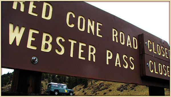
| Red Cone |
White River/Dillon
Pike/South Platte |
970-468-5400
303-275-5610 |
Closed |
9/25/13 |
COMMENTS:
9/25/13 - No, downed trees reached 1/10 of mile from gate. From there another dozen trees have fallen across the road.
At least a dozen downed trees across the road. It's going to take some major chainsaw work & winching to remove them.
6/30/13 - Open all the way. Gates on both ends have been opened.
Good conditions. Very little mud, no snow.
6/22/13 - Gate still closed.Significant snow still at the end of the trail (just past the wicked steep part),
as viewed from the end of the valley south of Webster Pass.
5/15/13 - Closed till at least July 1st. The seasonal gate will remain closed until Mile-Hi Jeep Club
can clear the trail of downed trees and snow. Work days are scheduled for the last weekend in June.
Hoping to have everything clear for a July 1st opening.
5/8/13 - Sign at Hwy 285 says trail is closed.
|
| |
| Red Canyon Park |
Canyon City |
|
|
|
COMMENTS:
|
| |
| Rollins Pass - East Side |
Roosevelt/Boulder |
303-541-2500 |
Open |
7/14/13 |
COMMENTS:
The trail is open all the way to the Needles Eye Tunnel. We traveled from the East side.
At about a half-mile from the tunnel, there is a snow bank that is roughly twenty feet long and 2-3 feet deep.
This bank pushes you over against the edge of the road. Most people turn around, but the experienced Jeep
drivers managed to squeeze through. Due to the risk of the road caving off, I would recommend waiting another
week. Other than that, the trail is in great condition.
6/16/13 - The trail was closed by snow at the 9 mile mark. Before that the trail was in good condition.
6/16/13 - Closed by Yankee doodle lake. So this might sound strange, but I just flew over this trail
and it looks 95% dry up to the lake and major snow drifts and a lot of them for the next stretch up to the
upper lake and the end of the road where you park to walk to the Alpine Tunnel.
5/29/13 - Not completely open. Made it in 6.5 miles.
Most of the road is fine. But the closer you get to Yankee Doodle lake, the snow drifts get deeper and bigger. Made it across one that was approx 50' long, but right after that was a an even bigger one. Called it day there.
|
| |
| Rollins Pass - West Side |
Arapaho/Sulphur |
970-887-4100 |
Open |
7/2/13 |
COMMENTS:
7/2/13 - Trail is open to the tunnel. Snow banks have been plowed open.
6/24/13 - No. Trail is open to the first trestle.
Blocked by many intermittent snow drifts. The drifts are melting slowly.
|
| |
| Red and White Mountain |
White River/Holy Cross |
970-827-5715 |
|
|
COMMENTS:
|
| |
| Saints John |
White River/Dillon |
970-468-5400 |
Open |
6/29/13 |
COMMENTS:
6/29/13 - Trail is Open all the way now and connects to Deer Creek Trail which is also open all the way.
Trail is in great shape with no issues to worry about.
6/16/13 - No, Gates are closed at the Deer Creek entrance and the Saint Johns entrance.
|
| |
| Santa Fe Peak |
White River/Dillon |
970-468-5400 |
Open |
6/29/13 |
COMMENTS:
6/29/13 - Trail was dry and open to the top.
Some snow melt near the top made the road a little wet on the last few switchbacks, but it was easily passable.
6/16/13 - Just above timber line snow drifts cover trail, drove through 2 drifts but shelf road with the snow drifts sent us back.
|
| |
| Saran Wrap |
Pike National Forest |
Near Colorado Springs |
Open |
5/11/13 |
COMMENTS:
5/11/13 - Open all the way. The trail was wet with fresh snow, but no large snow drifts to deal with.
|
| |
| Schofield Pass |
White River/Sophris District |
970-963-2266 |
ATV only |
7/22/13 |
COMMENTS:
7/22/13 - There are several areas that had apparent slides since I did this last year. I heard that a group of
Jeeps came up early in the weekend and cleared the trail. It's open and we had no
problem in our 4DR Jeeps.
7/19/13 - Due to heavy rains in the area the trail is blocked by a rock/mud slide about 1/2 mile west of the Devil's Punch Bowl.
We dug out a small opening to allow an ATV to pass. But had to turn around in our jeep.
7/1/13 - The trail is open all the way.
There is a fallen rock above the punchbowl that could make the road impassable, but a bypass around the rock
has been started.
6/15/13 - South side is open all the way to the top. North side has lots of deep snow left.
I saw three people get stuck trying to break through the snow on the north side. It's just too deep still. Needs another week or two before the pass will be dry enough to get to schofield park.
|
| |
| Scotch Creek |
Uncompahgre/Ouray |
970-240-5300 |
Open |
6/1/13 |
COMMENTS:
6/1/13 - Open according to the Forest Service.
|
| |
| Sevenmile |
San Isabel/Salida |
719-539-3591 |
Open all year |
4/2/11 |
COMMENTS:
Open all year, snowy and slushy, but doable.
|
| |
| Shrine Pass |
White River/Holy Cross
White River/Dillon |
970-827-5715
970-468-5400 |
Open |
6/22/13 |
COMMENTS:
6/22/13 - Open all the way.
|
| |
| Sidney Basin |
Uncompahgre/Ouray |
970-240-5300
970 |
|
|
COMMENTS:
|
| |
| Slate River Road/Paradise Divide |
|
|
|
|
COMMENTS:
|
| |
| Slaughterhouse Gulch |
Pike/South Platte |
303-275-5610 |
Open |
All Year |
COMMENTS:
According to the forest service, this trail is open all year.
|
| |
| Slide Lake |
White River/Holy Cross |
970-827-5715 |
Open |
7/5/13 |
COMMENTS:
7/5/13 - Completely open and snow-free and dry. We were pre-running
trails in the area in preparation for All-4-Fun at the end of the month and everything in the area is now open.
Wildflowers are also in full bloom, including amazing amounts of Columbines. :)
|
| |
| Spring Creek |
Arapaho/Clear Creek |
303-567-3000 |
Partially Open |
5/26/13 |
COMMENTS:
5/26/13 - Bashed open to connection with Cascade Creek. This was before fresh snow fell a few days later.
|
| |
| Stony Pass |
Uncompahgre/Ouray |
970-240-5300 |
Open |
7/26/13 |
COMMENTS:
7/26/13 - It's open all the way. Trail is in good shape.
7/10/13 - Open on west side. Closed on east due to forest fire.
6/27/13 - Closed due to fire.
5/12/13 - The trail up Stony Pass was completely open.
8ft snow walls on either side of the road near the top, did not block the road.
|
| |
Summitville Trail
FR250, FR330, FR380 |
Rio Grande/Conejos
| 719-274-8971 |
Partially Open |
5/28/13 |
COMMENTS:
5/28/13 - Open on the Del Norte side past the 11,900 ft pass but unpassable high unplowed snow on the Monte Vista high side.
Call to NFS had advised they thought it open. Obviously only one side was open. Probably one ranger district / county had cleared their side while the other side had not.
|
| |
| Swan and Wise Trail, middle fork |
White River/Dillon |
970-468-5400 |
|
|
COMMENTS:
|
| |
Taylor Mountain
CR228/FR330 |
Chaffee County |
719-539-6961 |
Open |
7/5/13 |
COMMENTS:
7/5/13 - Open all the way back to highway 50 at Maysville. Was a great half day trek from Gunnison,
awesome views all the way over the top, road splits left fork sharp hairpin then road not
passable right fork good to more views, saw graves of kitty and chopper.
7/2/13 - Open according to the Forest Service.
5/26/13 - Eastern loop of the trail is only clear for 6 miles to the rock quarry. After this there is deep off camber snow drifts.
|
| |
| Taylor Pass |
Gunnison/Gunnison |
970-641-0471 |
Closed |
10/04/13 |
COMMENTS:
1/04/13 - Today's snow storm combined with high winds has closed the pass for the season.
6/29/13 - Open all the way to the summit lake from the Taylor Park side. We met vehicles coming from Aspen and they said it was clear over there as well.
Also, American Flag Mountain is totally clear.
Water running strong in the creek but easily passable.
6/14/13 - Made it within 50 yards of summit from Taylor Park side. Probably another couple weeks before it will be open to top.
Snow near top, water flowing pretty strong where trail runs in creek.
|
| |
Tincup Pass
FR267 |
San Isabel/Salida
Gunnison/Gunnison |
719-539-3591
970-641-0471 |
Open |
7/3/13 |
COMMENTS:
7/3/13 - Made it over the pass today in our stock Toyota sequoia. Hugged snow some near the top on the St Elmo side.
7/1/13 - The trail is still closed at the top due to one snow drift across the road. Foot traffic can make it by the
drift. Trail is in good condition. Saw lot's of wildlife while going up to the snow pack.
6/29/13 - Still blocked near the top by a snowbank ~1/8 mile from top.
6/16/13 - From the St. Elmo side, the pass is blocked by a sizable snowbank at about 12,000ft. Give this three weeks of melting or two weeks if a large, determined crew goes up there and does lots of work.
The Gunnison side is clear and could be driven to the pass with ease.
USFS told us on Friday that it was completely open...
6/14/13 - According to the Forest Service this is still closed due to snow.
6/4/13 - Contacted San Isabel/Salida Ranger office 5/29 prior to heading down to Gunnison area for Weekend of 5/31-6/2
camping trip. Ranger I spoke with stated that Tinsup is likely to be July 1st as a best guess. Cottonwood was plowed
for Memorial day and there are +/- 10 foot cuts. Tincup has similar snow but is unplowed. It will be a while.
5/9/13 - Fresh wet snow at the start of the trail. Drove up half a mile or so.
|
| |
| Tomichi Pass |
Gunnison/Gunnison |
970-641-0471 |
Open |
6/30/13 |
COMMENTS:
6/30/13 - Trail is open all of the way.
6/14/13 - According to the Forest Service this is still closed due to snow.
5/31/13 - Trail blocked by snow about 1/8 mile above last cabin, at 1st runoff stream crossing.
Riding R1200GSA motorcycle, stopped by large patches of snow across trail, just starting up the first section
where the trail gets rocky and rough. Snow had to be much deeper further up.
|
| |
| Treasure Mountain Loop |
Uncompahgre/Ouray |
970-240-5300 |
Open |
6/1/13 |
COMMENTS:
6/1/13 - Open according to the Forest Service.
|
| |
| Twin Cone |
Pike, South Platte |
719-836-2031 |
Open |
6/9/13 |
COMMENTS:
6/9/13 - Open to the top. Trail is in great shape.
6/1/13 - Busted through the snow drifts above treeline, but the final snow drift on the ridge line is impassable for another week or so.
|
| |
| Uncompahgre Plateau Area |
Grand Valley |
970-242-8211 |
Partially Open |
5/2/13 |
COMMENTS:
5/2/13 - Roads starting to open. Divide Road FR402 open to 0.5 mile south of Divide Forks Campground
Big Creek Road (FR403), Uranium Road/Indian Creek (FR404) are open, Calamity Basin (FR405.2A) and
Cow Mesa/Balloon (FR405.4A) are open, but no road conditions reported.
|
| |
| Wager Gulch |
Uncompahgre/Ouray
BLM/Gunnison |
970-240-5300
970-641-0471 |
Open |
8/7/13 |
COMMENTS:
8/7/13 - The trail is dry and open to Carson. It is likely open to the end of the trail, but we did not go past Carson.
|
| |
| Warden Gulch |
White River/Dillon |
970-468-5400 |
Open |
6/29/13 |
COMMENTS:
6/29/13 - Trail is completely dry and open.
|
| |
| Wearyman Creek (FS747) |
White River/Holy Cross |
970-827-5715 |
|
|
COMMENTS:
|
| |
| Webster Pass/Handcart Gulch |
White River/Dillon
Pike/South Platte |
970-468-5400
303-275-5610 |
Open |
7/20/13 |
COMMENTS:
7/20/13 - As of July 20 Webster Pass is open. A group of 4-Wheelers shoveled the snow drift out of the way. We drove up Red Cone and down
Webster Pass. Webster Pass does have water running down parts of the road from the snow run off, but the road is good.
7/15/13 - Open to motorcycles today after some shoveling.
7/5/13 - From Montezuma, the trail is open to the top of the pass.
It is blocked by a LARGE snow cornice just over the top on the Grant side. I wouldn't plan on this
pass being open until the middle of August at the earliest, if it opens at all this year.
6/30/13 - North side gate out of Montezuma has been opened. Trail is clear to the top of the pass, but you cannot make it down into Grant because of the giant snow cornice still.
6/29/13 - The trail is blocked by about 15' of snow just before the one way descent from Red Cone. We pushed through the snow just after the narrowing of the road on the first switchback.
6/22/13 - Not open all the way to the top. Approached from the south, turned around an the north end of the valley, where road narrows and begins to ascend steeply up to the pass, just past the first switchback, as there was still significant snow up on the pass.
Up until it's blocked by snow right at the pass, the trail was great, easily doable in a stock Jeep Wrangler,
with some minor creek crossings only a few inches deep. No mud.
6/16/13 - Not open all the way. Trail blocked by snow 1/2 mile passed the creek crossing on the Montezuma side, creek crossing 26-30'' deep.
|
| |
Weston Pass
CR7 |
Pike/Fairplay
San Isabel/Leadville |
719-836-2031
719-486-0749 |
Open |
6/16/13 |
COMMENTS:
6/16/13 - Open all the way. Clear, dry, and open all the way.
5/10/13 - On the west side, we were able to get to approx 3.5 miles past the forest boundardy.
The snow is melting fast. Keen travelers would probably be able to get farther - we turned around
at that point as it was getting a little deep for solo travel.
5/5/13 - The trail is clear to about 10900' on the eastern slope. There is packed snow at this point but it can be negotiated. We didn't bother since it was late in the day.
The trail is mostly dry with some puddling from the melt. Ruts are non-existent at this point. There are 3 sections that have snow across the road, two are passable and one we did not attempt due to a lack of light.
|
| |
| Wheeler Geological Area |
Rio Grande/Conejos
| 719-274-8971 |
Closed |
5/28/13 |
COMMENTS:
5/28/13 - Confirmed closed (via physically visiting the closed gate at trailhead)
Access is open to trailhead (at the outhouse) where it is closed (via a closed and locked gate). Confirmed with nearby NFS employee that they thought it wouldn't open for another 2-3 weeks due to snow. Access dirt road to that gate is fully open and clear with no issues.
|
| |
| Wheeler Lake |
Pike/South Park |
719-836-2031 |
Open |
6/17/13 |
COMMENTS:
6/17/13 - It is open up to the long loose rock hill near the top. When you turn that corner it's got a huge snow bank.
Looks like an ATV or something, maybe a small truck or Jeep has gone up it but to the right side
and dug out the side birm of the trail a bit. I could have made it with mine but the possibility of making
that side worse isn't worth it. Please do not do that!
6/16/13 - We made the Lake! The trail has the usual puddles and the "mud pit" is all there. Nothing a stock vehicle cannot handle. Bowling ball hill has patchy snow going up the south exposure heading west. When you make the hard right and keep going up there is a big snow bank. We had to winch over using a land anchor we brought and put in the snow. Once past that there are a couple of small snow patches and one large snow field about 50 yards across that we were able to drive on. Once that starts to melt it might pose a problem for a few days. It's about 2 feet deep.
|
| |
| Williams Pass |
San Isabel/Salida |
719-539-3591 |
Open |
8/1/13 |
COMMENTS:
8/1/13 - Open all the way through. A little wet but not bad. Brush makes the trail narrow for full size vehicles.
Went over it with a Bronco II on 33's and a Jeep and a FJ on 35's. All vehicles locked front and back. No damage.
6/12/13 - The road is open only during the month of Aug. The rest of the year the gates on both end are closed.
|
| |
| Wurts Ditch Road |
White River/Holy Cross |
970-827-5715 |
Open |
7/5/13 |
COMMENTS:
7/5/13 - Completely open and snow-free and dry. We were pre-running
trails in the area in preparation for All-4-Fun at the end of the month and everything in the area is now open.
Wildflowers are also in full bloom, including amazing amounts of Columbines. :)
|
| |
| Yankee Boy Basin |
Uncompahgre/Ouray
BLM/Gunnison |
970-240-5300
970-641-0471 |
Open |
7/31/13 |
COMMENTS:
7/31/13 - Trail is open all the way.
Easy drive in a 4-wheel drive vehicle. And, it's comical to see some of the regular street cars that people manage to get very far up the trail before they finally crap-out. I can just imagine what the bottoms of those cars must look like by the time they make a round trip into Yankee Boy.
Point here is: what Yankee Boy is most known for is the lovely flower fields.
But, by the end of July of 2013, the flowers were pretty much finished.
5/22/13 - Drove rest of trail today. Clear to the Yankee Boy rest area. Trail snow covered 500 feet past there.
5/13/13 - Drove all the way to the Ruby trust mine. It was snowing and wet. Sneffels and Camp Bird mines in operation so trail
was nice to them. Would have driven farther but was getting late. Heavy equipment traversing from the mines.
|
| |
| Yankee Hill |
Arapaho/Clear Creek |
303-567-3000 |
Open |
5/27/13 |
COMMENTS:
5/27/13 - Open from Alice to Central City.
Trail snow is mostly gone along the main route. The trails that lead toward Apex still have quite a bit of snow,
3-4' drifts. Run planned for today 6/2/2013 will post up more info later.
|
| |
|
|
|
|
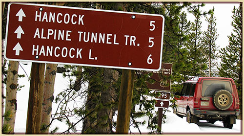 This is
the page for the 2013 Colorado Pass page. You can add to this page and
This is
the page for the 2013 Colorado Pass page. You can add to this page and


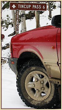 As a guide, you can view the dates and information from the